Sunday, December 20, 2020

After the Storm: Snow and Sea

Photo taken Dec 19, 2020 at 1:02 PM

I am all but certain these birds are Canada Geese floating in the water. Maybe they are taking a break from flying south. Maybe this is as far as they will go. I suspect the water is actually warmer than the ground would be and the birds are waterproof.

--December 19, 2020 at 1:02 PM. Warwick, RI, United States

On Wednesday night, December 16, 2017 a Nor’easter1 blew in and dumped at least 6 inches of snow on us along the coast (far more inland especially in northern Rhode Island). The storm left behind plenty of snow. The snow was not the light fluffy type, over 2 feet of it, that friends of ours reported shoveling clear in Albany, NY; it was wet and heavy. Moe than enough to get the lower back muscles to announce complaints the day after plenty of driveway clearing. But with the work comes the pretty sight of fresh snow. Snow on the ground and snow in the trees. Snow making the bright red cardinals and numerous other birds more vibrantly visible as they visit a bird feeder. Snow muffling sounds except when you crunch across the frozen crusty layer and hear great crunches with each step. With the return of the sun on Saturday it was time to brave the black and not-so-black ice that was left behind and go for a walk.

I’ve written about Rocky Point before and it is certainly nice having this park so close by. Being able to walk to the shore of the bay and just enjoy the plessure of being there makes the just-over 2 mile large loop walk so much more fun. That remains true even when other people are around and there were quite a few people about on this 34°F afternoon. I suppose they had the same idea: get out of the house and enjoy the first special snow of the season as best as can be done given the pandemic.

I certainly enjoyed my walk. The kids sledding on the short but steep hill by the pier were enjoying themselves. I am sure the small groups of fellow walkers were having fun. And, of course, the dogs attached to people were enjoying the snow too. I’d like to think the honking of the scores of Canada Geese as they bobbed in the water were honks of pleasure.

Enjoy the video and remember to get out when you can even for a small adventure near your home.


  1. [definition](https://www.weather.gov/safety/winter-noreaster ↩︎

Monday, November 30, 2020

A Walk in the Woods

Photo taken Nov 29, 2020 at 11:42 AM

The family.

There is no doubt that this year has been full of trials for everyone. For some the trials have been most severe including the loss of loved ones. We must do what we can, within the bounds of safety, to alleviate these trials: getting outside certainly can help. Photo taken Nov 29, 2020 at 11:22 AM

If you are particularly fortunate you have places that are just far enough away from the hustle and bustle of daily life to give you a sense of nature. You are not just strolling through the streets of your neighborhood. Take those opportunities to explore.

Photo taken Nov 29, 2020 at 11:49 AM

Fall folliage in full bloom and hanging on for just a bit longer. This oak tree (pretty sure) is hanging in there.

You do not need to go on a big adventure. If you can find a place near your home to just stroll in nature that will do a lot to make the stroll more than just a mere walk in your neighborhood. If you can get out with friends and family, safely of course, so much the better. The point is to relax and remember that even today the world is still a wonderful place.


Tuesday, November 17, 2020

Notes on the Waterloo-Pinckney Trail and our Weekend Backpacking Trip

Notes on the Waterloo-Pinckney Trail and our Weekend Backpacking Trip

Photo taken Nov 7, 2020 at 10:07 AM

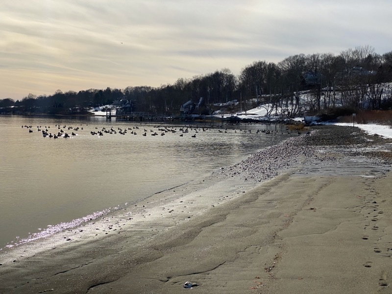
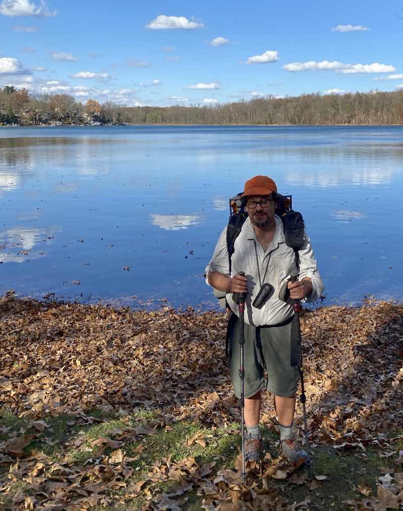
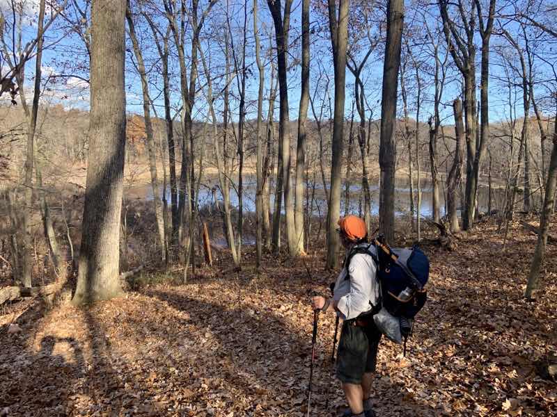
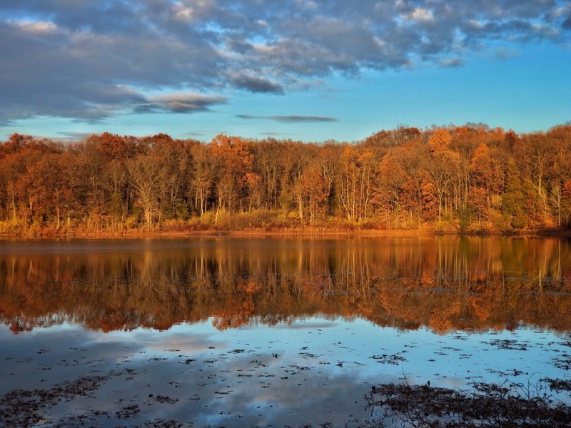
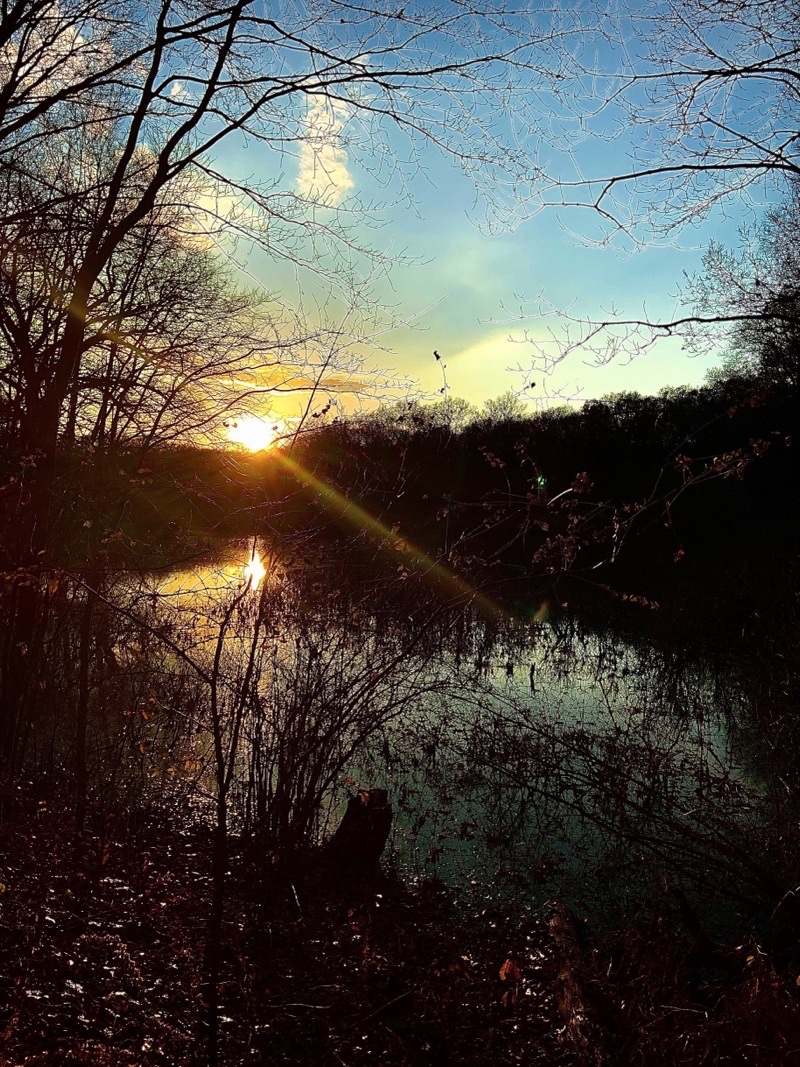
Portage Lake is the western terminus of the Waterloo-Pinckney Trail. It’s an active lake with plenty of recreation taking place especially on a fine warm morning such as this. Time and location approximate. Photo by Andrew Mytys

--November 7, 2020 at 10:07 AM. Pinckney, MI, United States

You probably have read the trip report on our NOvember 7-9, 2020 backpacking of the Waterloo-Pinckney Trail. Some of my companions have made some cogent comments that I am going to address here in this post. They’re mostly expansions on things I wrote then and provide a bit more detail about issues you might also encounter if you decide to tackle this trail.

How to Hike the Trail

Direction of Travel

While there is something to be said for hiking east to west as your are leaving traffic noises behind the first several miles of the Waterloo-Pinckney Trail are shared with the Potowatomi Trail which is predominantly a bike trail. The general rule is bikers ride the trail east to west while hikers travel west to east. Even with this traffic management approach you need to pay attention to the bike traffic which frequently moves rather quickly and can be upon you before you know it.

Markers

The Waterloo-Pinckney Trail is blazed with dark blue marks. This is especially helpful in keeping you on track in the area where the horse riding trails abound.

Footing

Overall the tread of the trail is hard packed dirt. But during autumn leaves, especially oak, will lay thick on the ground. They obscure the trail and make the tread-way more slippery. The former attribute probably contributed to Doug’s ankle trouble as he hit a hidden rock. The latter made descents, some steep, more challenging than they would otherwise be.

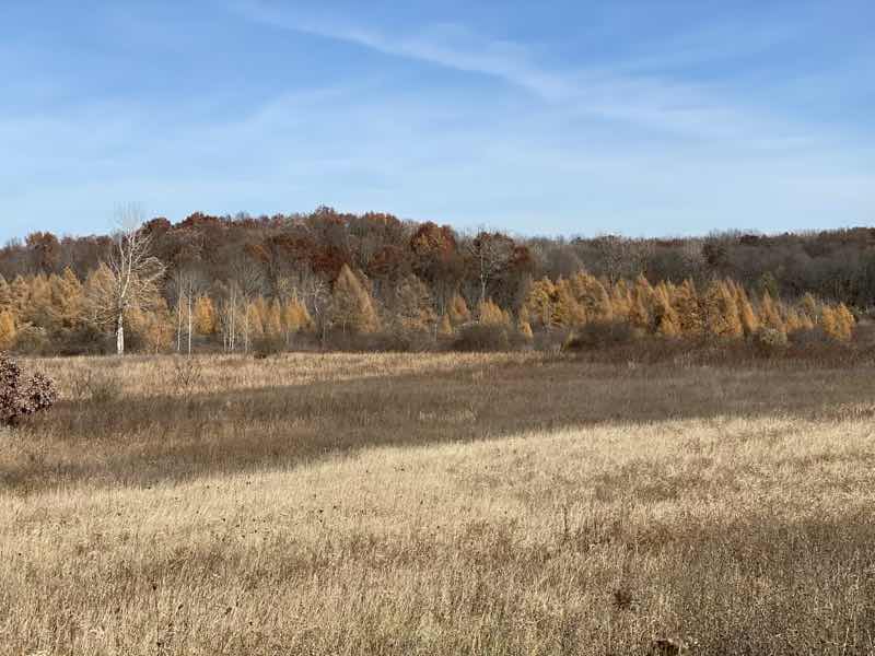
In the vicinity of the Horseman’s Campground the Waterloo-Pinckney Trail is used by both people and horses. More or less bounded to the west at Katz Road and Loveland Road on the east the footing becomes increasing sandy and full of ruts as you move deeper into the area. It’s worst between the Baldwin Flooding and Clear Lake Road. You will likley find it tougher going than you expect from a examination of the topographic map.

The 2020 Re-Route

For decades the trail made use of what it could to get where it needed to be. By M-52 that meant traveling up a private drive before entering state owned land and a proper trail. It also meant crossing M-52 which is a busy road.

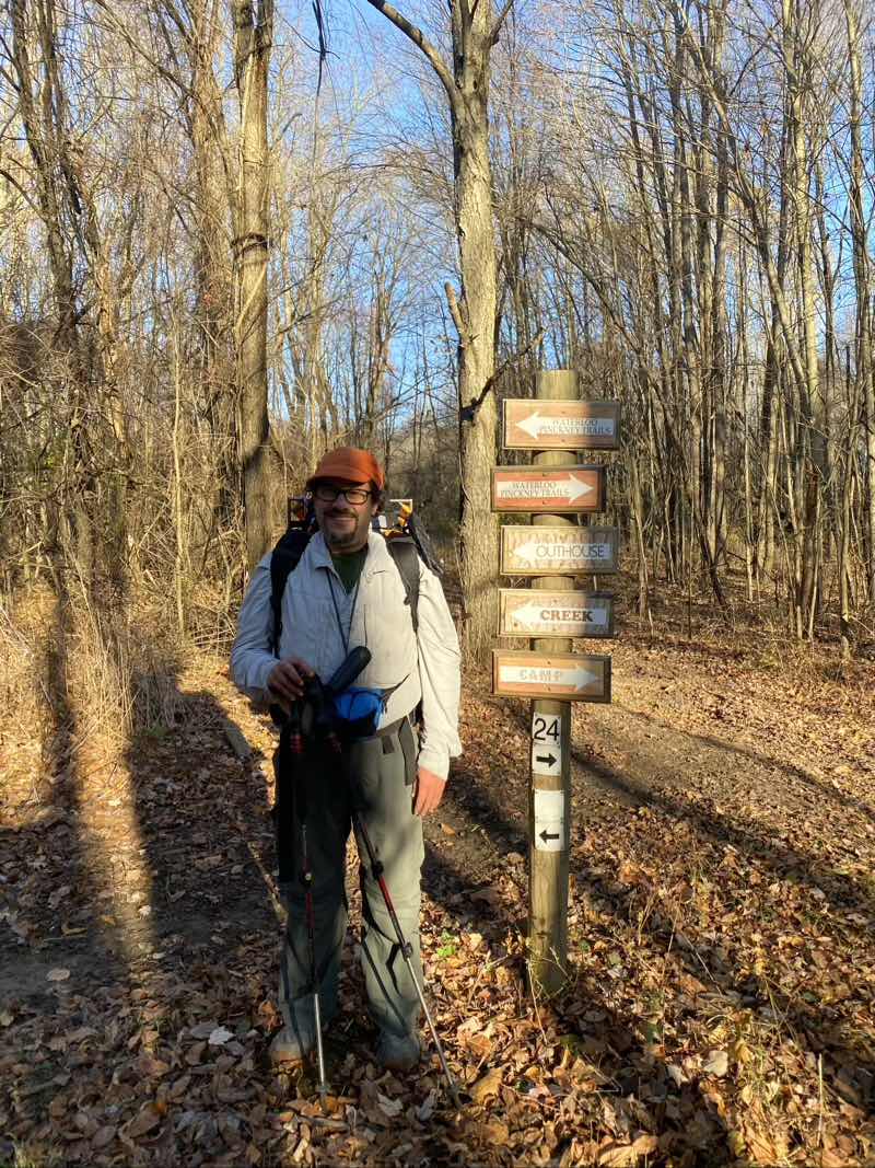
In 2020 the bike-path and its tunnel under M-52 were completed. The trail follows the bike path under the tunnel and there is new, as of this writing unmarked though surely that’s only a matter of time, trail just past the tunnel. That is the new Waterloo-Pinckney Trail which Mike elected to locate and follow while Andy and I having realized we had missed the turn (MIke had to backtrack a bit) decided to follow the trail that climbs over Stofer Hill and then use map and compass, staying on ridges avoiding the marshy lower ground, to make our way to where the Waterloo-Pinckney Trail would be. It is a pretty short bushwhack once you leave the trail that climbs Stofer Hill (there are side trails to the top and to the north that you could follow but if you try to dead reckon your way to the Waterloo-Pinckney from those points you will likely encounter marshy ground). However, it is certainly an unnecessary detour as the new Waterloo-Pinckney Trail exists. Just pay attention. Make sure you have the most currently available maps. The new Waterloo-Pinckney Trail intersects the bike path within 0.1 miles east of the tunnel. The trail then travels pretty much due east for about 0.6 miles before making a sharp turn to the north and heading towards Lyndon Park. As of this writing, November 15, 2020, the trail that connects the bike path to the Waterloo-Pinckney Trail is not marked and the old trail that crosses M-52 and use the private land is still marked as Waterloo-Pinckney Trail. Use the new trail. Be a good steward of the lands.

Water Sources

This is definitely not a complete definitive list of water sources on the Waterloo-Pinckney Trail. There are certainly some sources that are going to be seasonal and I am not mentioning them. The ones I do cite I am pretty confident will be flowing, when water flows, year round. These water sources are not potable. They should be treated either through filtering, chemical purification, UV purification, or boiling.

From Portage Lake to Pines Campground

There are two reliable sources between the trailhead at Portage Lake and Pines Campground. There is no water at the campground itself and the water at the horse stables, about 0.5 miles away, is only available May 1 through September 30 1

Water is available at a decommissioned dam about 3 miles from the trailhead (well my GPS track has it further than that) but just east of Willis Road.

Water is available about 0.6 miles west of Pines Campground in the Baldwin Flooding.

Pines Campground to Green Lake

You’ll go right by Crokked Lake and near Mills Lake. But you also cross over McClure Creek and North Fork of McClue Creek later in the section.

At the third intersection with McClue Road (going west to east) you’ll find a lovely water source but the ground is very soft and apt to suck your shoes off. Footing is better south of the intersection.

  • Point on map
  • Green Lake to Silver Lake

    You can find water flowing in Lyndon Park after the pavillion. However, access can be tricky as you cross boardwalks above the water. I was able, with a stretch (and I’m only 5’4” or so), to reach my Sea to Summit Bucket down to fetch water. Mike stuck his trekking pole through the strap to later lower that same bucket to get a re-fill. There are a few places like this where you could fetch water but you won’t be able to just dip your water bottle in.

    Water is available at Blind Lake which is 0.25 miles off the Waterloo-Pinckney Trail.

    There is a water source about 0.3 miles east on the Waterloo-Pinckney/Pototwatomi Trail east of the junction to Blind Lake.

    At the southeast corner of Pickeral Lake the Waterloo-Pinckney/Potowatomi Trail intersects with an unnamed trail that heads northerly towards the Silver Lake Trail. Follow the spur trail and then Silver Lake Trail about 300 feet to a footbridge that spans a creek that flows between Pickeral Lake and a small unnamed lake. If you pass the unnamed spur trail you will quickly encounter to Silver Lake Trail which you can take north to the same footbridge. The distance is comparable either way you go.

    More Resources

    You can find plenty of information out there about the Waterloo-Pinckney Trail. A lot of it is not particularly current and the trail has seen some substantial changes over the years. As I’ve noted elsewhere reported trail mileage distances vary and while I do not claim my numbers are going to jibe with your experience I do believe they’re prety reliable and that it is a bit better to be a bit high rather than low as far as distance travelled goes.

    Maps

    I’ll share my GaiaGPS maps and if you want to find others I know of at least on track on CalTopo and I expect AllTrails has them too. Keep in mind that with the new re-route if you have older maps they certainly will not be current and even a recently downloaded map (November 9, 2020) doesn’t show the new re-route as Waterloo-Pinckney but does show that a trail is present.

    Gaia GPS Track

    DNR Maps

    These are PDF maps from the Michigan DNR that will certainly give you an overall sense of how trails connect with each other.

    Pinckney State Recreation Area

    Waterloo State Recreation Area

    Camping

    You must say at designated campsites. For purposes of backpacking the Waterloo-Pinckney Trail I’d suggest your options include Pines Rustic Campground (no water or ground fires), Green Lake, Blind Lake. There is camping at Portage Lake. Other campgrounds exist in both Waterloo and Pinckney Recreation Areas but aren’t on the Waterloo-Pinckney Trail. Keep in mind that campgrounds are spread out in both recreation areas so you will need to search both Waterloo and Pinckney when making reservations (Blind Lake is in Pinckney; the others in Waterloo).

  • Michigan DNR Reservations
  • Hiking Style

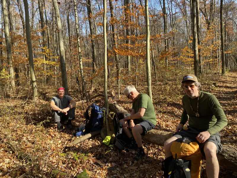
    start by talking about hiking style. Our breakfast break at Lyndon Park was planned and ran 45-60 minutes (some dispute on that but that’s OK; I know we took 2 hours 16 minutes in breaks on the third day). The lengthy break at Blind Lake was also pretty much decided upon as we approached the lake and no one complained. It can be tricky to meld disparate hiking styles together especially when some people are just going to always be slower than others. The point to keep in mind is that breaks do tend to consume time more quickly than you might expect. I knew our breaks on day 3 were about as long as they turned out to be. I was surprised that I used up about 70 minutes on day 1 though my time spent searching for the lost camera and then waiting for Doug to retrieve my glasses certainly accounts for a not insignificant portion of that time.

    More Photos

    You had a chance to see some photos from the previous post but others took photos too and I did not include everything I could have.

    Day 1: Portage Lake to Pines Campground

    Photo taken Nov 7, 2020 at 2:31 PM

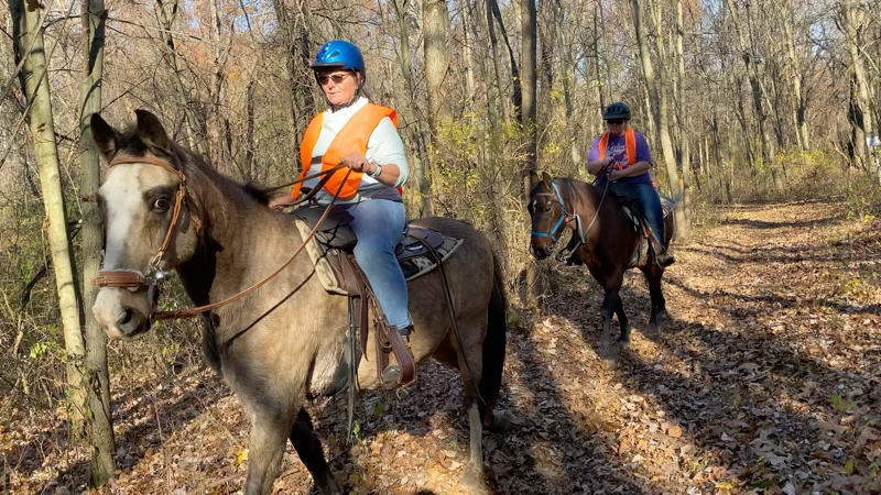
    This twosome would raise the horse and rider count to 9. They were nowhere near the last horses we would see today. We would see quite a few Saturday morning as well.

    --November 7, 2020 at 2:31 PM. Grass Lake, MI, United States

    Photo taken Nov 7, 2020 at 3:40 PM

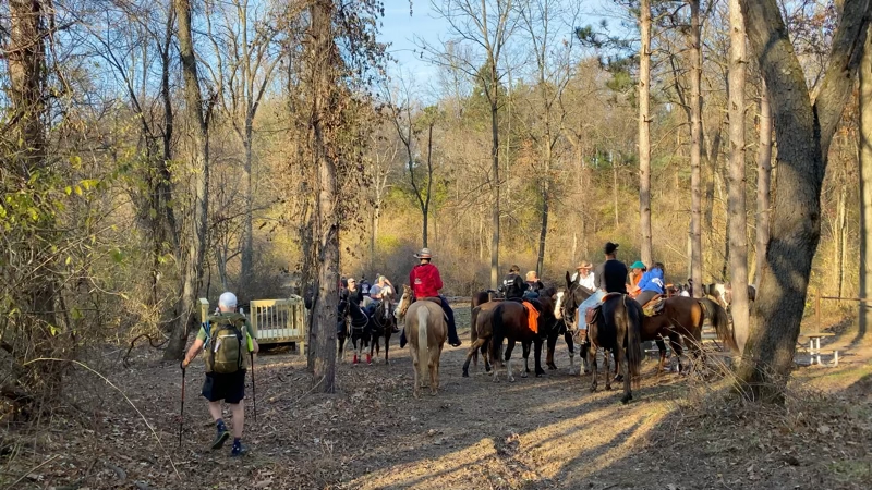
    Our arrival on this scene of well over 20 horses and their riders milling about this stream. We could backtrack, not at all a short ways, or ford the stream. I was figuring on taking my socks off, sliping my shoes back on, and wading across. Doug was not keen on this idea. The horse people suggested they give us rides. Perhaps they said it with a joke in their hearts but they were serious and we took them up on the offer. I did less well than Doug.

    --November 7, 2020 at 3:40 PM. 12891 Trist Rd, Grass Lake, MI, United States

    Photo taken Nov 7, 2020 at 3:44 PM

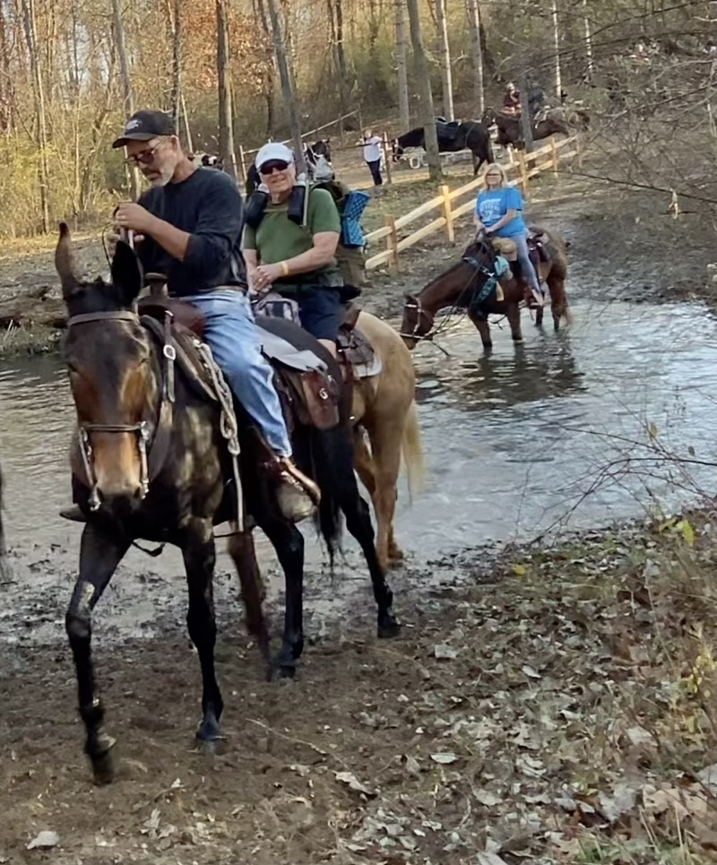
    Doug looks a lot happier and more comfortable on his horse than I am sure I did on mine. I sat behind a fellow and he admonished me to, “breathe.” He may have been right to do so. There were easily a score of horses and their riders at this crossing.

    --November 7, 2020 at 3:44 PM. 12891 Trist Rd, Grass Lake, MI, United States

    Photo taken Nov. 7, 2020 around 4:50 PN

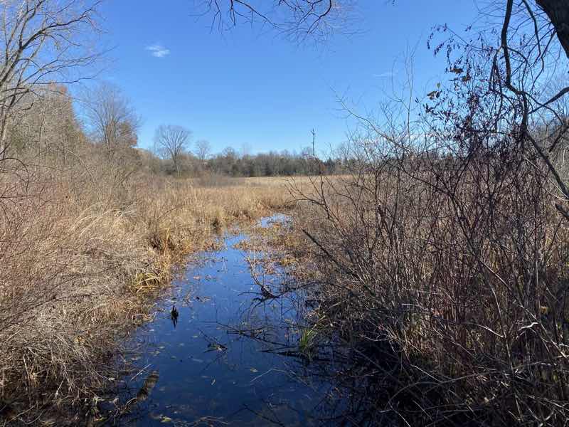
    Baldwin Flooding. This is where you will find a decommissioned dam and access to water. It’s about 0.5 miles west of Pones Rustic Campground. Time is approximate. Photo by Mike Fogarty

    Day 2: Pines Campground to Green Lake

    Photo taken Nov 8, 2020 at 4:15 PM

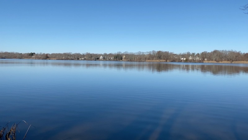
    Green Lake in full fall foliage glory. Andy got to camp about 20 minutes before Mike who arrived about 20 minutes before I did. Time and position are approximate. Photo by Andrew Mytys

    --November 8, 2020 at 4:15 PM. Chelsea, MI, United States

    Day 3: Green Lake to Silver Lake

    Photo taken Nov 9, 2020 at 8:40 AM

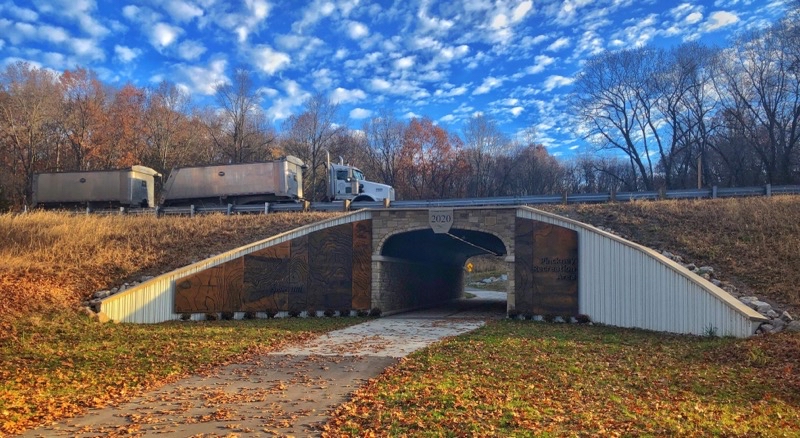
    The tunnel that we now get to use to safely deal with M-52 and all its traffic. This is part of the new, as of 2020, re-route that gets the Waterloo-Pinckney Trail off private land and away from danger. Photo by Andrew Mytys

    --November 9, 2020 at 8:40 AM. 18034–18272 M-52, Chelsea, MI, United States

    Photo taken Nov 9, 2020 at 9:08 AM

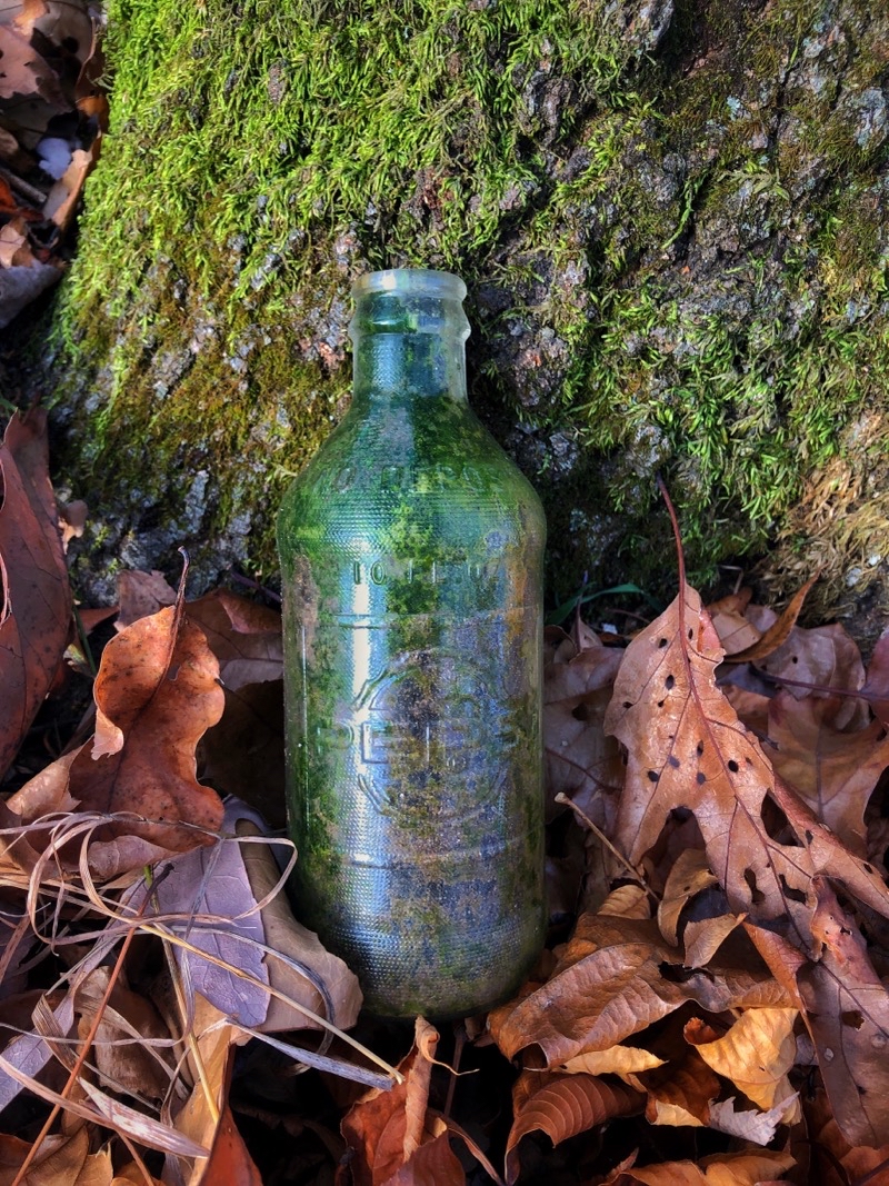
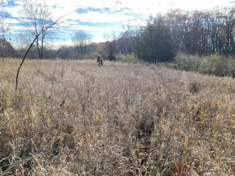
    We were working our way through the tall grasses following a deer trail (yes, I could see it too) towards where we believed the Waterloo-Pinckney Trail had to be. At this point the trail is probably about 0.1 miles east of us. But this is an area that has clearly seen human visitation before. Perhaps not all that often as we suspect this Pepsi bottle is older than Andy or I. Photo by Andrew Mytys

    --November 9, 2020 at 9:08 AM. Chelsea, MI, United States

    Photo taken Nov 9, 2020 at 1:05 PM

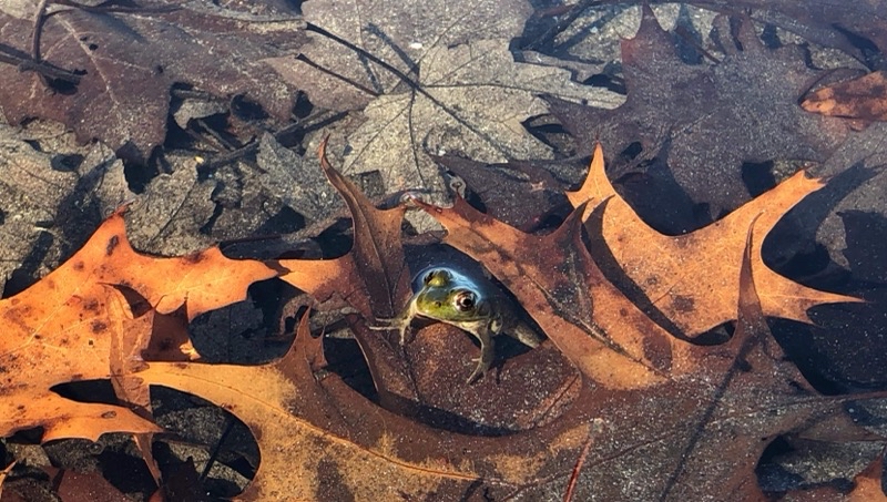
    Blind Lake is a fine place to have lunch. It is a remarkably clear body of water as you can tell as you peer down upon this Leopard Frog. Phto by Ander Mytys

    --November 9, 2020 at 1:05 PM. Gregory, MI, United States

    Photo taken Nov 9, 2020 at 4:45 PM

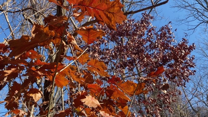
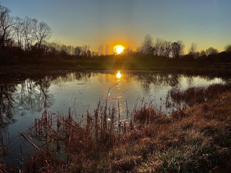
    By the time I would reach this plant the sun was not glinting off of it as it is here and I doubt I was that far behind. This was taken probably around 4:40 PM. This is the last pond we would pass before ending our hike. Photo by Mike Fogerty.

    Sunday, November 15, 2020

    Backpacking the Waterloo-Pinckney Trail: A Stunningly Warm Autumn Adventure

    The weekend before rifle deer season and usually right around the birthday of a close friend people would gather at the old Schoolhouse in White Cloud, Michigan for a weekend of conviviality and outdoor fun. We started this tradition November 1999 and up until this year even though the Western Michigan Chapter of the NCTA sold the Schoolhouse we thought we would have our usual Gathering. COVID-19 has thrown those plans out. Paul and Julie took their family (Julie is the birthday girl) up north for a car-camping weekend of fun and one person joined them (Steve) but the Gathering was a non-event this year. Andy Mytys suggested a backpacking trip for the traditional weekend of the Gathering and along with Mike Fogarty and Doug Wood I joined in for this trek of the Waterloo-Pinckney Trail.


    This would be a new hike for me. I’ve certainly walked the entire trail in sections before but never backpacked the whole thing. I don’t think I have even set foot on the trail since Andy, John, Dennis, and I set out on a winter solstice at dawn to hike from Big Portage Lake to Lyndon Park probably about 15 years ago. The trail has changed some over the years. While the trail has changed the information about it may not have. You can find sources that give different lengths such as 36 miles long1 and 33.9 miles 2. You will find different distances cited for campgrounds on the trail too. Take this all with a big grain of salt. While I am fully willing to admit that a GPS track has inherent errors in it I do not think my record track is that far off from the actual feet-on-the-ground experience. when you plan a trip keep in mind that the map is only a model of the reality on the ground and that model may be out of date. Over the course of the weekend I logged just over 42 miles. That does include hiking to and from Green Lake and Blind Lake. It includes no doubt some cumulative error though I think that is likley very small. It also includes the unintentional detour Doug and I took on day 1 which likely added about 1.0 mile to our hike. If I had to say what the most likely distance of just the Waterloo-Pinckney Trail is I would suggest 38.5 miles with the biggest discrepancies from other sources being found between BIg Portage Lake and Pines Campground and from Green Lake to Silver Lake. For those that want to dive into the nitty-gritty of how my feet trod the Waterloo and Pinckney Recreation Areas you can view the GPS tracks:

    Day 1: Portage Lake to Pines Campground

    We hoped to be on the trail by 09:30 and earlier would have been lovely. But no plan survives contact with reality it seems. Andy’s ETA slipped but that hardly mattered because so did everyone else’s ETA. Toss in confusion on how to get to Portage Lake for some and we all were there a little before 10:00. Of course, by this time the already sunny morning had warmed up considerably and Doug proved to be the smartest of us all in that he was already down to pretty minimal layers of clothing. We hoisted our packs, probably all weighing in between, 21-23 pounds with all our stuff and plenty of waternote on water sources, and struck out on the trail at 10:01.

    Under the ever-present sound of crunching oak leaves we quickly left the parking lot and some traffic sounds. Now and then we would be treated to the eerie honking calls of Sandhill Cranes flying past. The lake was soon left behind for the rolling hills of the Waterloo Recreation Area. It is easy walking at this point. Navigation is also straightforward early on which is nice. We could relax into the hiking and enjoyment of the unusually warm sunny day. That’s what we did as our gorup spread out into distinct sub-groups with Andy and Mike in the far lead.

    photo taken November 7, 2020 at 11:17


    Left to right: Mike, Doug, Andy. Time for a late-morning break.

    --November 7, 2020 at 11:17 AM. Grass Lake, MI, United States

    photo  taken 13:37

    Now and then we will come up on one of these grassy open expenses. They never last long Brar a nice change of scenery.

    --November 7, 2020 at 1:37 PM. Grass Lake, MI, United States

    It was a lovely day and even though the climb up Sackrider Hill seemed to take more out of me than it should have I was enjoying myself quite a bit. Just being outside in these conditions was more than enough reward for a bit of harder work. I am sure everyone else felt the same way. But it couldn’t really last: at least the ease of hiking couldn’t last. Doug and I got into such a nice groove that we failed to make an important turn near Baldwin Flooding. We figured it out, we had suspicions already, when we came to a stream with well over a dozen horsemen and horsewomen with their horses all getting ready to trot through the water. We were completely off the Waterloo-Pinckney Trail. Should we retrace our steps or ford the stream and figure out where Pines Campground was from this point. Doug didn’t want to cross and get his shoes wet. I figured mine would dry and I could just either go barefoot or take my socks off and let the shoes quickly dry. The horse-people had another idea: give us rides across. We took them up on that notion. I made something of a hash of it just getting on the horse. What a stretch. I’m clearly not limber enough to swing my right leg up and over while wearing my pack. I needed a shove. Doug manned the whole affair, actually riding alone on a horse (I sat behind a fellow), far more adroitly than I. I’m grateful for the short ride but I must also say that it was a bit nerve-wracking being up there swaying back and forth.

    After that we made fine time until I belatedly realized my glasses had fallen off. Doug scampered on back to the stream where the horse-people still were and they had found my glasses. What a surprise. But with our navigational goof and this final mishap we still hauled ourselves and our gear into camp around 16:30. What a day: and we still had camp chores including dinner to contend with.

    but joyous taken 18:50

    We all fiddled with the fire in my Firebox G2 Titanium 5” stove (Mike’s going at it ) . It’s always a bit surprising how quickly it burns out. I think to really use it well it requires wood of much greater thickness than we used. Obviously you can cook with the stove but you need to provide lots of TLC to do it properly. We are nowhere, especially me, as competent with fire as say the stove’s creator is. But it did work.

    --November 7, 2020 at 6:50 PM. 12891 Trist Rd, Grass Lake, MI, United States

    I brought the 5-inch titanium Firebox stove on this trip to play with. This is not normally how I would cook. Making a wood-burning fire that you can cook on takes a lot of work. I broke up sticks into various sizes and it was not enough. Andy broke up more. We fiddled with the fire and it burned hot and too fast. Maybe if we had used much larger chunks of wood, akin to a fire torch approach, we could have done better. But my faux-quessedillas came out pretty well. My apple crisp-like dessert got burnt but the parts that did’t burn were quite tasty. Doug shared a lovely turmeric tea (think that’s right) with all of us. But by about 20:00, as we listened to the church group in the other campsites repeatedly pray to Mary, we crawled into our various shelters and sleeping bags to go to sleep.


    Day 2: Pines Campground to Green Lake

    Doug’s ankle had been bothering him the pervious day and he decided to play things safe and bail out. He would hike minor roads (maybe hitch) back to his car. He declined any offers to keep him company and no one pushed it. He was off pretty early on and Andy not far behind. Mike and I took a bit longer but we set out on the trail at 09:00 which was pretty good and could have been quicker had MIke and I not elected to have hot breakfasts (oatmeal takes forever to eat it seems).

    During the night the temperature dropped down to the low-mid 40s. I slept well in my Enlightened Equipment 50F quilt within my silk liner. Andy was probably wearing his usual sleeping clothing, long johns, and maybe a bit more under his tarp within a Serenity bug bivvy and he said he was comfortable too. That’s high praise given he sleep colder than I do. throughout the night we heard coyote yip and bark in the distance. I suppose they caught something. Some type of owl hooted but I couldn’t tell what it was. When the sun rose we heard Sandhill Crane cry as they flew south.

    Photo taken November 8, 2020 at 9:08


    We could certainly wish for more signs like this later on. There are numerous side trails that connect to the Waterloo Pinckney Trail. In this area they are predominantly horse trails and with signage is present and maintenance done is typically done by the local Horsemens Association. It can get quite confusing. Photo by Mike Fogarty

    --November 8, 2020 at 9:08 AM. Grass Lake, MI, United States

    The hiking in the vicinity of Pines Campground and for quite a few miles around is upon sandy trail. Numerous trails form loops that intersect with the Waterloo-Pinckney Trail. It’s something of a mess. If you don’t have a decent map and ability to locate yourself either with solid knowledge of the area, a GPS, or both you can easily got confused. The footing on the trails just adds to the irritating nature of the hiking here. Horses just beat trails up.Mike and I were up to the task and did not get confused. We were very happy when the horse-riding trails subsided as we slowly approached Clear Lake and the Waterloo Recreation Area headquarters: lunch spot.

    We didn’t meet quite as many people on horseback during the morning as we hiked but that’s probably only because we were hiking out of the domain of the horse and rider. At our lunch spot we settled in for a time to relax and eat what we had. A few people came on by and asked what we were doing. Quick chats. A fine way to spend time outside. But after probably more than enough time had elapsed we gathered up our packs and struck out once more towards Green Lake. For time time we kept company with a young lady and her new puppy. That was a nice bit of conversation. But she was going to turn off in time, as her pup was flagging just a bit, and we would keep on heading towards camp.

    The trail footing is so much better once you leave the domain of the horse. No ruts. No sand. The trail rises and falls through many small hills which you notice as you climb them (more descend as you worry about slipping). The literature suggests that the trail mileage between Pines and Green Lake is 12.5 miles. That’s likely a bit short but probably not by more than 0.5 miles. But it’s a tough 13.5 miles even though none of the hills is really much to write home about. Andy was at camp well before me. Mike wasn’t far behind Andy. I arrived at 16:30. By the time I showed up it was cooling down a litle bit. Our sunny day was still going pretty strong and the high was well into the mid-70s. It was nice to relax and get ready for our second night. I fully planned on eating my pasta dinner, using the alcohol stove, but Andy had other ideas. Chelsea is only about 5 miles away and surely a pizza place would deliver to the campground. Well our first place we called doesn’t do delivery but Jets did and so a large Detroit-style pizza was ordered. Took something like an hour to reach us but we enjoyed the special treat - pizza was OK not great - of ordered food. I suppose we stayed up later because of the late dinner but we had nowhere we needed to be. A fine way to end the day.

    Day 3: Green Lake to Silver Lake


    Photo taken November 9, 2020 at 8:32


    This is as gooda view of Green Lake as I would get.

    --November 9, 2020 at 8:32 AM. 18347–18505 M-52, Chelsea, MI, United States

    Our final day and it was going to be the longest day even by the data we gleamed from the literature. That suggested a distance of 13 trail miles so 13.5 miles from our campsite. I had my doubts. We planned to be on the trail bight eyed and early and have breakfast at the pavilion in Lyndon Park which the literature suggests was only 2.0 trail miles distant. There is what the map presents and then what the feet trod. Their was a great difference this morning. The map didn’t show the re-route that was made to avoid having to cross M-52 and then walk up a private drive. That re-route takes you down a paved bike path about 0.5 miles to a tunnel which then if you are paying close attention as you walk the continuing paved path has an unmarked trail leading east into the woods. That’s the trail you want to take and it will link up with the “old” Waterloo-Pinckney Trail in 0.5 miles. We missed that turning. Andy and I decided to strike out for new territory and find the trail via bushwhacking. Mike wasn’t keen on that idea as he was worried about marshy ground so turned back to find what we clearly missed.

    Photo taken at 9:10


    We have climbed Stofet Hill and are making our way along deer trails towards the Waterloo-Pinckney Trail. Andy braves a path through the tall grass. Here we avoid slipping on leaves though the grass does hide branches to trip over.

    --November 9, 2020 at 9:10 AM. Chelsea, MI, United States

    Andy and I soon found a trail that would climb through rasberry bushes and other brush slowly gaining the near-top of Stofer Hill. As we climbed we learned Mike had found the trail and was making good time. We held out a faint hope that we’d be faster than him and could get to Lyndon Park first but I suppose that was foolish. Our semi-maintained trail faded away to be replaced by game trails that we managed to follow pretty well. No marsh. We came into a meadow and knew that the Waterloo-Pinckney was not too far away. Just keep heading the way we were going and we would hit the trail. We did. Our extra exploration certainly added distance to our day; Mike’s did too. The re-route had we found it straight off would have as well though a bit less. Everyone had fun and we all reached Lyndon Park eventually though Mike was well ahead of us.


    Our warmest if not quite clearest day. But I think the clouds make the sky stand out more above this wet grassy area.

    --November 9, 2020 at 11:00 AM. Chelsea, MI, United States

    We spent too long at Lyndon Park. It’s not as though we had big deal breakfasts we just dawdled. Over the course of the entire day we would take 2 hours and 16 minutes of breaks (that’s my breaks; bet Andy and MIke got more). Breakfast and lunch took up the bulk of those pauses and while they probably were worth it (lunch for more so as it was prettier) we probably should have taken those breaks in more even chunks. The strategy of taking a short break every hour or so instead of a couple huge breaks and several short ones now and then really does have a lot to recommend it.

    P taken at 12:04


    Carry a bucket or other water carrier you can attach a line to ( or has a long enough strap already as my Sea to summit bucket does) to fetch water from spots like this.

    --November 9, 2020 at 12:04 PM. Gregory, MI, United States

    It was our warmest day yet and I suspect we all felt the need for water. I know I certainly did. Too bad treating water, using my Sawyer Mini in this case, seems to always take longer than you would wish. I should’ve brought the Katadyn BeFree instead and I certainly can see the appeal of UV-light purification systems that take only a minute. I’m just not sure I trust them as I saw them break in the past. However, that past is a decade ago and I know the technology has improved since then and people whose outdoor expertise I trust use them.

    photo taken at 13:53
    Ken after lunch at Blind Lake. It’s worth the 0.25-mile walk down to the lake for a relaxing break. If you’re lucky you will spot bullfrogs and leopard frogs as Mike and Andy did. Photo by  by Mike.

    --November 9, 2020 at 1:53 PM. Gregory, MI, United States

    photo taken at 14:32

    I believe this is Dead Lake. Does that mean we shouldn’t get water from it? We just walked on by. Photo by Mike.

    --November 9, 2020 at 2:32 PM. Gregory, MI, United States

    We marched on and on. Andy and Mike pulling ahead and waiting for me to catch up. Blind Lake, Dead Lake, Pickerel Lake. They slowly came and went and we plodded on. Had we wanted to not walk the whole Waterloo-Pinckney (OK, we already blew that) Trail we could have shaved at least a couple miles off the hike by not following the Potowatomi Trail all the way. But that wasn’t the choice we made. With little fanfare we worked our way past the last unnamed lake, through a lovely pine grove, and then to the rocky bit that lasts at most a tenth of a mile before ending at the parking lot for Silver Lake. You don’t even see the lake. Sunset was just past and twilight was settling in as we quenched our thrist with iron-tasting water at the Silver Lake pump. The hike was complete.

    Gear List

    This was put together a bit haphazardly but is substantially complete and accurate. As you can see the wood-burning stove is a huge weight. An alcohol stove, like my Evernew titanium Trangia-style burner with Trangia simmer ring (carried but I forgot to put in the list) with fuel weighed 120 grams. Had I gone solely alcohol I’d have carried more fuel but the total would likely have been only a third as heavy at most.

    Gear weight(grams)
    ZPacks Solplex with 8 stakes 500
    NeoAir xtherm 455
    Enlighten Rquipment 50 290
    Design Salt Silk Liner 115
    Vargo ExoTi 50 Backpack 1465
    Kitchen
    Firebox G2 titanium 5” with 4 firrsticks and Cordura Pouch 580
    Self Reliance 1L Titanium Pot 160
    Kieth Titanium Mug 55
    frypan (no handle) not sure if it’s an MSR or Trangia 125
    Pot lifter 20
    Trimmed Fat Daddio 4x2” baking dish from Flatcat Gear 60
    Stuff Sack 20
    Fork/spoon 5
    Firebox leather gloves 95
    smart wool t shirt 80
    2 pairs socks 120
    Underwear 70
    Buff 35
    Packa rain jacket 255
    Kuiu Peleton 97 L hoodie 140
    10,000 Anker battery 215
    Petzle bindi lamp 34
    Garmin inReach 130
    Microphone 68
    Tripod 194
    Phone mount 96
    Compass, knife, fire starter 120
    Wallet baggie (cash, ID, credit card, insurance card, emergency info) estimate 92
    Toiletries , first aid 205
    Trowel, tp, sanitizer, body glide 140
    CNOC 2L bladder 90
    Sawyer mini and back flush syringe 80
    Sea to Summit bucket 65
    Gear weight (g) 6174
    Food bag (Sea to Summit waterproof with OP sack and bear hang kit) 100
    Food estimate 2100
    Starting water 2000
    total estimate (g) 10374
    Wearing
    Hiking pants, undies 390
    REI long sleeve shirt 230
    T shirt 70
    Socks 60
    Altra Lone Peak 4
    Wintergreen hat 34
    Monocular 98
    Worn total 882

    1. From Wikipedia ↩︎

    2. Pure Michigan ↩︎

    3. just really two reliable sources of water. One is at a decommissioned dam just east of Willis Road about 3 miles from the trailhead. The second about 0.5 miles west of Pines Campground ↩︎

    Monday, November 2, 2020

    Bisquick Muffin Bske on a Trangia Stove

    photo taken 8:26 AM

    A Trangia burner sitting inside a 5” titanium G2 Firebox Stove. A big muffin is baking in the Self Reliance pot using a round 3x3-inch dish.

    I am getting ready for a two-night backpacking trip. Since this is going to be a short trip, under ridiculously warm weather conditions for the season, on pretty gentle trail, I think I will tackle more involved cooking. I hope to use my large titanium Firebox stove. The 6’5-inch G2 titanium stove in its Cordura case weighs in at 600 grams (21.25 ounces). If I use the Trangia with simmer ring that will add another 95 grams (3.3 ounces). I’ll bring the alcohol burner as backup in case I fail to make good wood-burning fires in the Firebox. I wanted to make sure I could do a long burn with the Trangia so I baked a big chocolate chip muffin. It was a tasty success.

    A lot has been written about backcountry baking and I doubt I can add much. I used a titanium pot from Self Reliance which has both a side-mounted handle and bail-style handle which should stay cool even if flames lick up the sides of the pot. My baking dish was a 3-inch diameter by 4’3 inches tall trimmed down Fat Daddios dish which I placed on a 0.5 or so inch tall spacer. I let it bake until the fuel burner out which was about 35-40 minutes and used up about 1.5 ounces of fuel which was certainly more than I needed. Cooking conditions: about 30 F (-1 C) with a breeze blowing around 10MPH (16 KPH).


    Tuesday, October 20, 2020

    A Weekend With Friends: Alum Creek and Lake Hope State Parks, Ohio

    photo taken October 10, 2020 at 6:40 PM

    Lil, Ken, Dawn, and Janelle. Lexi the dog.

    --October 10, 2020 at 6:40 PM. Furnace Ridge Rd, New Plymouth, OH, United States

    A few weeks ago a friend and I were sitting on my deck, reasonably distanced, enjoying an experiment in food and beer. The old-style apple raisin fritters were a success (and then I learned Lil doesn’t like cooked apples so an even bigger hit). During that time conversation wandered around to talk of friends some of whom we don’t get to see often even when the world isn’t engulfed by a pandemic. Lil had the bright idea that since our friend couldn’t readily travel here for a relaxing weekend we could go to her and take her on a relaxing, winding-down, weekend. Out of that initial thought came some ideas of places to go that would be new and exciting for all of us. We changed places as planned gelled and issues came up. The plan firmed up more with a place settled upon and another friend deciding she could join us for at least a little while if not for the whole weekend. Our weekend adventure to Alum Creek State Park and then, for two nights, Lake Hope State Park was born.

    This car-camping trip was really more about spending time with friends and giving everyone a chance to enjoy the company of people they’ve known for years in a situation where, for a time, it would be possible to step back from the larger world. We might rub against each other in odd ways at times, nothing every goes quite as smoothly as you envision, but the opportunity to decompress remains. If the physical location itself has worthwhile attributes that is a bonus.

    Photo taken October 9, 2020 at 1:31 PM“ title=“” tooltip=“” style=“width: 353px; height: auto;

    Alum Creek Lake. At the northern end of my short paddle. It was a lovely autumn afternoon.

    --October 9, 2020 at 1:31 PM. Delaware, OH, United States

    Lil and I stopped at Alum Creek State Park on our way to fetch Janelle (and dog Lexi). This park is known for a biking trail and is also popular among boaters of various types from paddlers to motorized craft. Alum Creek Lake certainly sees plenty of boat traffic and the creek has charm. Lil had a good, if tough, bike ride and I managed a nice little paddle in my old trusty Alpacka Yak packraft.

    We got Janelle and Lexi loaded into the too-full truck (proving once again that nature abhors a vacuum by filling the F150 to the brim) and drove off to Lake Hope State Park. With one thing and another we didn’t arrive until just after sunset. We quickly learned just how sloped our campsite was. We used chunks of firewood to level out the picnic table so we could use it without fear of everything sliding off. Too bad we couldn’t level out the tent Lil and I shared. But we were there and our first night by a roaring campfire eating hotdogs-in-cornbread (sort of pigs-in-a-blanket) and coleslaw was working out quite well.

    That night set the pattern for the rest of the weekend. Eat decent food (even if messed up a bit), enjoy good conversations especially after Dawn arrived and we talked her into staying the night (she had already been leaning that way and it just took a tiny nudge), and time spent hiking, biking, or just relaxing under the trees. The weekend would give us all what we were hoping for: good time with friends.

    Video Note

    For those that care the video was shot using my iPhone 11 Pro and a new camera out for its first use: an Insta360 Go. This camera is bout the size of your thumb, weighs about one ounce, and is meant to take action shots in short clips of 15, 30, or 60 seconds. It has a single very-wide-angle lens and shoots 1080p video at 25 frames-per-second (technically it is shooting at 2700x2700 but the app it uses to export video only does so at 1080p which is a shame because it throws away so much data). There is no screen. You point the camera in the direction you want to shoot and push the shutter button (or use the Bluetooth connection and app to do the same thing). A video (regular or slow-mo, hyperlapse), picture, or time-lapse, is tkaen. When you connect the camera to your smartphone the app you’ve installed will let you transfer the data to your phone for processing and sharing. No muss; no fuss: in theory. It does work and once you begin to understand the limitations the insta360 Go certainly has uses. It isn’t anywhere as flexible as a more traditional action-camera but for what I wanted it seems to have worked well enough. You’ll likely have no trouble figuring out which shots were from the Go and which the iPhone. I should also note that the video was edited entirely on the iPhone using Luma Fusion.


    Sunday, October 4, 2020

    Coleman Stove First Use: Faux Biscuit

    Photo taken Oct 4, 2020 at 2:30 PM

    Two-burner Coleman propane stove with a Lodge 3.2 quart Combo Cooker. With a stand this becomes far more Dutch oven like. There is no reason I couldn’t mound coal below and on the lid if I were cooking over a fire. If I could’ve bought a traditional style Dutch oven I would have but the size I wanted wasn’t available at least not soon enough.

    I don’t car camp that often. But I do it enough that I finally decided it was time to buy a classic-style (hardly classic as the original version is definitely built of stouter materials) two-burner Coleman propane stove. The stove arrived last week and I managed to find increasing hard-tp-find Coleman propane fuel canisters. Are people feeling a need to become more-prepper-like or are they car camping or tailgating more? I do not know. Now that a damp fall afternoon has arrived I have decided it is time to try using the stove and an also new dutch-like-style oven. Time to try and make a set of biscuits.

    I’m was too lazy to make an actual biscuit dough but thought that Bisquick with bits of butter folded in might work. Perhaps it does work and I just failed to make the biscuit properly. Given my skill at cooking this seems all too likely. Long story short I thik had I treated this ore like a frybread project it wouldhave worked out better. You can learn more the experiment worked out watching the video.

    Photo taken Oct 4, 2020 at 3:09 PM

    The top looks great. The bottom was sadly rather burnt.


    Thursday, September 24, 2020

    Food on the Deck: 18th Century Apple Raisin Fritters

    Photo taken Sep 22, 2020 at 6:24 PM

    Lil. Getting ready to make the apple fritters. They’re about as simple as can be: flour, apples, raisins (optional), hard cider. Make a paste-like batter that holds the fruit and fry to perfection.

    I have been thinking about food. Probably everyone has been thinking more about food and cooking it during these unsettled times. What is new for me though is I am actually cooking more. I doubt I’ll ever truly be good at cooking. I doubt I’ll take anywhere near as much pleassure from it as some do. However, I will admit that when I have made a successful meal I get a surge of joy especially if it was something I was feeding to other people. Those other people likely only will appear in certain restricted circumstances. Greater numbers, though still small, when camping. One other, likley that will be all, when cooking on the deck as I do here. In both cases my attention seems to focus on possible foods I could take on a camping trip or even backpacking trip. The former is more likely to be a car camping excursion. Given these conditions the food I will make is apt to be simpler fare. That doesn’t mean less tasty just fewer ingredients and less complicated cooking. Sometimes that means I can delve into the past for ideas based on the idea that 200 and more years ago people were less likely to create complex recipes except for special occasions and certainly only rarely if they’re less well off. Looking at frontier cooking, cooking for travellers, and the like can be a source of inspiration. That is how I came across this Apple Fritter recipe idea from Townsend’s Savoring the Past blog. I probably came pretty close to the recipe except for the fact that I pan-fried my fritters instead of deep frying them.

    Photo taken Sep 22, 2020 at 7:23 PM

    Ken. The apple fritters are done and it is time to eat. Photo by Lil.

    Ingredients and Notes

    • 1 Large apple
    • 2 cups (about) flour
    • 12 ounces (about) hard cider
    • 2 fistfuls of raisins (wish I had used more)
    • Sprinkled salt on fritters when done cooking them
    • Enough oil to cover pan for frying.

    This actually ended up serving 2 people. I expect an efficient cook can prep and cook this in 20 minutes. I took a bit longer. I’m not sure how many calories though I expect it would be around 1,100 for the whole recipe with the flour accounting for about 900 calories.I’m not sure how many raisins are in two handfuls. The alcohol would cook off so not contribute to the calorie count (I think).

    Recipe

    1. Dice the apple into small pieces. Remember to core and de-seed it (though I wasn’t that careful with the latter one time I did this recipe and it was fine).
    2. In a bowl add flour and slowly mix in the hard cider (you could also use a brown ale or just water). Your goal is to create a paste-like batter.
    3. After making the batter mix in the apple dices and raisins. Get everything well coated
    4. Heat your frying pan with oil to a good frying temperature. Sizzling.
    5. Using a soup spoon or a bit bigger drop modest-sized (heaping spoonful) globs of mixed batter into the pan. Tap them down to flatten them a bit.
    6. Fry until they begin to brown nicely. Probably about 4 minutes but it could vary.
    7. Flip the fritters and continue to cook them for a similar amount of time or until the appear golden brown on both sides.
    8. Take them out of the pan and salt them to taste.

    We found that they do absorb oil as they cook so if you make more than one batch (we did 2 in a 10-inch pan) you may need to replenish the oil coating like we did. We used just enough oil to coat the pan.


    https://youtu.be/h7KHyVPuXcg

    Thursday, September 17, 2020

    A weekend on the Au Sable River

    Photo taken Sep 12, 2020 at 12:29 PM

    Paul and Ken. At the boat landing by the remains of Durant’s Castle. Durant was, like Mason, a major landowner. Mason held more land and it is his name the Tract we walk bares.

    --September 12, 2020 at 12:29 PM. Roscommon, MI, United States

    Since we could not go to Wheatland Music Festival due to its cancellation Paul came up with the idea of doing a car camping trip someplace else. He invited me (and I invited a friend who could drive us there) to join his family at the Canoe Harbor State Forest Campground. This campground sits on the bank on the Au Sable River (South Branch) not too far from Grayling, Michigan. While I suppose I have driven through Grayling this is an area I know virtually nothing about. Certainly the first time I’ve ever camped here. For that alone I am very thankful Paul invited me along. I hope you enjoy this glimpse into our relaxing weekend at this uncrowded campground along what is generally considered one of the prettier rivers in Michigan whether you are an avid fisherman or not.

    In the video I make a consistent mistake referring to the west branch of the River. I note that I think that is wrong but I never did try to correct it. We are definitely on the south branch.Mason would buy Durant’s land. Mason bequeathed the land to the State to be kept as a permanent game reserve.1


    Tuesday, May 19, 2020

    George B. Parker Woodland Refuge

    I woke up this morning thinking it was going to be at best a partly cloudy day. It was almost cloudless. A fine day for a final hike in the forests of Rhode Island before I have to return to Ann Arbor to do some things that I cannot avoid doing any longer (not sure how long I’ll stay in Michigan). We would visit the George B. Parker Woodland Wildlife Refuge which is owned by the Audobon Society of Rhode Island (like Maxwell Mays wildlife Refuge - see visit of a few days earlier there). When we pulled into the parking lot around 09:45 skies were still virtually clear, winds rustled the leaves and branches up high but we barely noticed them, and the temperature was edging towards 60°F. A fine morning to spend walking through the forest.

    Previous hikes I would categorize as easy walks. Little elevation gain and loss and good footing make those trails in Arcadia and Maxwell Mays easy introductions to southern Rhode Island. Today would be a bit more challenging. This property is supposed to include fields as well as forests and streams but our modest lollipop-shaped hike would not expose us to any fields or even glades. The closest we would come were areas where the forest grew slightly less dense.

    The standout feature of the first part of the hike was extensive boardwalk. While much of it is in good shape there are segments that clearly need some tender loving care to remove nails that stick up, seriously sagging boards, and some boards that are not at all secure. The bridge-segment, complete with railings, is in good shape even though it has a bit of a lean. There must be some rather wet regions that the trail works its way through but the forest doesn’t seem to change.

    Photo taken May 19, 2020 at 10:25 AM

    This is just part of a homestead composed of several buildings (foundations at least). It was most likely originally owned by the Vaughn family and built in 1750. I am not sure when the homestead was abandoned or why it was left. Sometime after people left fire destroyed a lot of structures. Back when it was active there would have been fields and pastures to support people and livestock. They may have had orchards too. One thing that was not obvious though was ready water access (my topo map suggests water may be present not too far north of where this photo was taken at the main farmhouse).

    --May 19, 2020 at 10:25 AM. Greene, RI, United States

    Photo taken May 19, 2020 at 10:31 AM

    Ken is standing in what likely was a cold storage room. The stairway gave access to this space from the outside.. Photo by Jonathan.

    --May 19, 2020 at 10:31 AM. Greene, RI, United States

    We joined the Coventry Loop Trail (dark blue, hard for me to see, blazes) and in short order came to the foundations of parts of the Vaughn Family homestead. This homestead was built in 1750. I’m not sure how long it was inhabited but at some point people left and a fire destroyed at least the wooden buildings. Still it is always fun to see what remains and imagine how people may have lived.

    Photo taken May 19, 2020 at 10:49 AM

    The trail is rocky and full of roots waiting to trip you up. Trees encroach the footbed too. We are not far from the Vaughn homestead which sits on Biscuit Hill. Jonathan is on the left; Ken is on the right. Photo by Judy.

    --May 19, 2020 at 10:49 AM. Greene, RI, United States

    The trail is definitely on the tougher side of easy or easier side of moderate depending on how you choose to view the world. Roots and rocks abound so step with a bit of care. The trail is also hillier. We gradually climbed for the first 1.5 or so miles before having the largest descent. At that point we were working our way around the loop sometimes nearing at least one swift-flowing stream. None of the climbs are long but compared to the previous two hikes they are noticable. It also seemed to me that at the start of the walk birds of various species were far more active than they were during the middle portion of the hike. I wonder why? You would think near a stream life would sound more lively.

    Photo taken May 19, 2020 at 11:19 AM

    The boulder of the day with Judy and Jonathan off to the right providing just a bit of sense of scale.

    --May 19, 2020 at 11:19 AM. 1670 Maple Valley Rd, Greene, RI, United States

    Photo taken May 19, 2020 at 11:58 AM

    There are about 100 stone piles, they look like cairns but it isn’t clear that is what they are, in this area. No one is sure why they are here or who built them. Theories range from the truly outrageous to more mundane. Chance are that at this point we will never know so perhaps it is best to just enjoy them for what they show: signs of human endeavors.

    --May 19, 2020 at 11:58 AM. 1670 Maple Valley Rd, Greene, RI, United States

    What makes this section most interesting to us are the cairn-like piles of stones. No one knows why 100 stone piles that look like cairns are scattered about the area. Theories range from what I could classify as nuts to more reasonable. We certainly can ignore the ludicrous ones such as the piles were crafted by Phoenicians or ancient Celts. Notions that farmers from the 18th or 19th century would have considered stones a nuisance to be gotten rid of as they cleared fields and used stones to build walls and homes but it isn’t clear they’d make cairns. Nor can we say Native Americans did or did not build them.

    Overall the hike was about 3.4 miles in length with about 320 feet of gain and 330 feet of loss. The weather stayed superb throughout the entire trip. We did not see anyone today.

    Sunday, May 17, 2020

    Breakheart Pond

    Perhaps spring has properly settled in. To be fair I should write instead that perhaps we have returned to temperatures and weather conditions that are closer to the typically expected conditions for this time of year. Ealier in the month, and for most of April, I feel confident in saying temperatures were well below normal with cloudy/rainy days well above normal. Taking a peek at weatherspark.com we find:

    Average Weather in May in Warwick Rhode Island, United States Daily high temperatures increase by 9°F, from 63°F to 72°F, rarely falling below 53°F or exceeding 83°F.

    It has been considerably cooler and wetter. But although next week isn’t shaping up to be as nice as these past few days I think it has become properly nice at last. With the weather being nice it would be a shame not to go out and explore at least a little bit. Even if the place being explored is one we have all been many times before: Breakheart Pond in the Arcadia Management Area.

    Arcadia is a multi-use recreation area which, among other things, means hunting and fishing are allowed. We donned our hunter-orange vests again. Over the couple of hours we were out we saw over 20 people and only a smattering of them were wearing significant amounts of orange. Some just did not know it was hunting season (turkeys I believe). We did hear quite a few gunshots throughout our time outside but they were never close. The boomed intruded on what was a lovely Saturday morning as temperatures rose into the low 70s under an almost cloudless sky.

    Our plan was to walk around Breakheart Pond. I am pretty sure we followed a lollipop path using the John B. Hudson, Hicks, Breakheart Trails. The walk is through forest. Unlike our walk in the Tillinghast Pond forest which took us through definitely different ecosystems, the area around Breakheart Pond feels like one great forest. No dead zones in this, mostly oak I think, forest.

    Many of the trails are well marked but bring a map because there are many old woods roads and un-marked trails in the area. We had a nice paper map but you can also find online printable maps1 or use what a mapping app provides.

    This is an easy walk that has a surprising amount of total ascent and descent, about 250 feet over the hill just south of Breakheart Pond.But you barely notice. We moved through the forest full of birdsong stepping over a couple small rivulets that Mom doesn’t think we have ever seen before. But the spots where it has been muddy in the past must be permanently muddy as we encountered mud this time too. Just step with care or deal with some moisture.

    At the start of the hike we encountered just two women who were clearly new to the area. We were able to give them some advice on which trails to follow. They struck out on the “white” trail which is a bit more rugged and certainly muddier than the “yellow” trail. Both trails lead to the pond so you can make a narrow oval loop with them if you prefer. When we reached the pond itself, easily as large as Tillinghast Pond, we found many cars in the parking lot. Some people were paddling kayaks and canoes, or rowing a boat, on the pond. No doubt others were hiking somewhere and we saw a few of them. Photo taken May 16, 2020 at 10:26 AM

    A couple streams were more rivulets than proper streams but we did cross some larger streams like this one. M --May 16, 2020 at 10:26 AM. 260 Arcadia Rd, Exeter, RI, United States

    Photo taken May 16, 2020 at 10:27 AM

    Ken rocking his orange vest on a lovely spring morning. Photo by Judy. --May 16, 2020 at 10:27 AM. 260 Arcadia Rd, Exeter, RI, United States

    We had thought we would make a slightly bigger loop and so struck out north on the Breakheart Trail. When we came to a junction, perhaps a third of a mile from the northern tip of the pond, we decided to start returning towards the pond. The path felt more like a very minor forest road and within a couple hundred feet we passed by a metal garbage barrel that was full. This seems like a peculiar place for such an item. There is nothing nearby. In fact, very soon after passing the barrel the road becomes very muddy and brush-laden. I am pretty sure we were not that far, as the crow flies, from intersecting the Hicks Trail but we decided to keep our feet dry and so retraced our steps back to the junction with the Hicks Trail.

    Photo taken May 16, 2020 at 10:24 AM

    There is a man-made stream in my parent’s back yard. The inspiration for that water feature comes from this stream doesn’t have a name but it is a nice swift water way. --May 16, 2020 at 10:24 AM. 260 Arcadia Rd, Exeter, RI, United States

    The bulk of the not-wearing-orange people we would encounter were in this area around the pond. I suppose the pond is the standout feature although I think that outside the immediate area by the roaring outflow and parking lot your views of the water aren’t that great. We found ourselves some boulders to settle upon and have a quick lunch before climbing out of the lowland where the pond lays. During this last stretch of walking we met a young couple carrying what appeared to be huge backpacks. As we got closer they turned into huge bed-like objects strapped to their backs. They told us that they were part of their rock-climbing gear. If you fell off the rock you would land on the cushion of the large, thick, foam pad. None of us have ever seen anything like that before. We weren’t sure where they would go rock climbing but perhaps they were just going to find a big boulder and practice falling off of it. Strange.

    All in all this was a nice morning ramble through the woods. It would be easy to make a bigger loop and spend moe time in the area of Breakheart Pond. Perhaps next time we will do just that.

    Saturday, May 16, 2020

    When is a Pond Not a Lake?

    The weather continues to be spring-like. We had planned a different hike but were forced to change our plans when we came up against a big traffic jam on the way to Arcadia State Park. We settled on Tillinghast Pond which is owned and managed by the Nature Conservancy. The management area hosts 13 miles of trails which wander through a variety of ecosystems. You can also paddle Tillinghast Pond which seems, to my eye, rather large to be called a pond.1 People also hunt and fish depending on the season, turkey season now, so we wore hunter-orange vests.

    I have visited this area a few times over the years. However, this time as we set out on our counter-clockwise loop it seemed to me that things were different. The forest didn’t seem as dense. Part of that could be put down to the time of year.Previous visits have been in the summer or perhaps early autumn. We passed through an area that had been deliberately cleared. We passed the remains of a homestead (water heard in the distance; in or out-flow of the pond) then wound our way along the twisting trail into the first of several dead zones. I don’t know what types of trees they were (some hemlocks and pines; many deciduous) but I do know the trees were all dead. Had I taken a photo it would show a ravaged scene with some signs of new low-growing life coming up in the much more open area. Cycles of life: but I find myelf wondering if this cycle was caused by something that should not be present. The way the dead zones change the feel of the area is remarkable.

    THe Flintlock Trail winds through a variety of ecosystems. Sometimes you move through a somewhat wetter area; sometimes drier; glades appear now and then sometimes clearly man-made. It seemed to me that there were far fewer birds about than we experienced in the woods at Maxwell Mays earlier in the week.

    Photo taken May 14, 2020 at 11:32 AM

    The big boulder of the day. The Flintlock trail wiggles a lot before reaching Tillinghast Pond. Sometimes it passes through stretches with exposed boulders but none as large as this one.

    --May 14, 2020 at 11:32 AM. West Greenwich, RI, United States

    Eventually after some climbing and descending (about 110 feet over the course of the whole loop - spanning the Flintlock Trail and the white-blazed trail) we caught our first glimpses of the almost glass-smooth Tillinghast Pond. We curled around the eastern end of the pond and soon came to the edge of the meadows and small dock that juts out into the pond. What a fine spot for a snack break.

    Photo taken May 14, 2020 at 12:16 PM

    Sitting on the dock of the pond, watching ripples roll away... We had a nice snack break here on the northeastern tip of Tillinghast Pond. A lone kayaker works his way west and we heard a hiker talking as he walked along the far shore (he and his fluffy white big dog caught up to us later).

    --May 14, 2020 at 12:16 PM. West Greenwich, RI, United States

    The medows are yet another ecosystem that you could cut across to save time but it is against the rules. The Nature Conservancy wants people to let the nature be and that is understandable. I wonder if there is an explosion of wildflowers in the meadows.

    The pond appears and disappears from view and after a short road walk we dipped back into the trail network for the final walk back to the car. We saw a lone paddler and two walkers and one dog. A fellow was standing by a boat in casting his fishing rod. I am sure there were more people about because we counted 8 cars evenly split between the put-in point and the parking lot where we parked.

    You won’t get a serious hiking workout in this area but you will enjoy yourself as you walk through forest, meadows, glades, and along the shores of a large pond.


    1. The dividing line between when a body of water becomes a lake or pond is a bit squishy. This article provides some interesting insight into the terms. I don’t know how deep Tillinghast Pond is but suspect it isn’t that deep which is a big part of why it is a pond and not a lake even though it is likely about 12 acres in size. ↩︎

    Wednesday, May 13, 2020

    The Tides of Life

    Photo  taken  May 13, 2020 at 5:59 PM

    Top: not quite the highest of high tides but close.
    Bottom: not the lowest of low tides but pretty low.
    — Warwick, RI.

    We are on a roll: two sunny days in a row. Tomorrow should be pretty nice too so perhaps a more typical spring is settling in here in the Ocean State. I decided to walk the beach at Rocky Point again. I was hoping to actually walk along the beach all the way to the pier that is being built. It is a rocky beach that is definitely submerged when the tide rolls in. Today, as the bottom photo in the duo-pic shows, the tide was out.

    Unfortunately for me, I was not the only one to have the idea of spending some time outside at this modest state park. I encountered a handful of families goofing off on the narrow strip of beach. One fellow was sitting on searock soaking up the sun. Parents and their kids were playing along the surf-line. I put my mask on. But I still felt it was too crowded. Would I have felt that way before COVID-19? I decided to retreat to the paved path above (maybe 15 feet above sea level) the beach. Here I found more people biking or walking. A few dogs too. My peace was gone.

    I think this may have been the greatest number of people I have encountered at Rocky Point. I wonder if more people will spend more time at parks since so many other opportunities to do things outside of the home are currently not available. While I am glad people are spending time in nature (such as it is in a former amusement park nestled amongst neighborhoods on the coast of Warwick Neck) I wish for fewer people so I don’t have to worry about viral loads being carried around.

    Tuesday, May 12, 2020

    Maxwell Mays Wildlife Refuge (and my eye)

    Photo  taken May 12, 2020 at 11:18:30

    My eye had been bothering me some before I went to the ER. I bet I’d be wearing dark sunglasses back then. Today in dappled but bright light I was more comfortable waring clearing lensed glasses.

    --May 12, 2020 at 11:18:30. Coventry, RI, United States

    Two weeks ago I spent the many hours in two ERs trying to learn what was up with my eye. The next day I went to a clinic for a closer check-up (based on the ER eye doctor’s recommendation). That visit lead to a return visit a few days later to see a cornea specialist. That visit determined that I needed sutures removed: they were loose or broken. For those of you with normal eyes this is something an ophthalmologist takes care of in his or her office: no muss; no fuss (snip snip you’re done pretty much). For me it is more involved: surgery requiring mild sedation. The surgery was scheduled but I think that was more challenging than normal because of COVID-19. COVID-19 certainly affects everything from the ER visit to time in the hospital. From a patient’s point of view forget visitors. The surgery went well and the sutures are no longer present and so my eye is much happier. I still do not feel as though I am reading as well as I should but that has been a long-term issue only worsened by the problem. I can tolerate normal light levels again which is good. And the maddening irritating feeling and pain are gone.

    Photo  taken May 11, 2020 at 11:16:00

    I didn’t have to walk up into the grass like Mom and I did last time when the tide was high. This isn’t miuch of a beach, certainly not one people will happily sunbathe on (those exist in Rhode Island but not here), but it is a beach nonetheless.

    --May 11, 2020 at 11:16:00. Warwick, RI, United States

    With the return of eye health I have been able to go for walks again. A return visit to Rocky Point on a blustery morning with a very high tide (not as high as last time but close) was one walk. I am so glad to have a wlk that is more interesting than a walk along neighborhood streets (all I really have back in Ann Arbor). Rocky Point is about 0.3 miles from the house. Sure, it is hardly a nature walk but it is more than a walk in on neighborhood streets.

    Photo  taken May 12, 2020 at 11:20:22

    I wonder where this boulder was located before the glaciers receded. As you can see it is quite large and no other boulders in the area are even close to the size of this one. Mom provides a bit of scale.

    --May 12, 2020 at 11:20:22. Coventry, RI, United States

    Photo  taken May 12, 2020 at 11:23:12

    The trails are blazed various colors. I believe we entered along the white trail before following the Hemmitt Hill (yellow) trail. But what caught our attention here are the two great cavities in the tree. I suppose woodpeckers could have made them but they seem rather large and low. Maybe a barred owl lives in one but I don’t think they create the cavities. So, what did?

    --May 12, 2020 at 11:23:12. Coventry, RI, United States

    The bigger walk, though only a bit longer, was along some trails in the Maxwell Mays Wildlife Refuge. We strolled through the meadow into a dense forest where Carr Pond sits. Our walk, and perhaps many of them, do not really give you good views of the pond for long. Instead focus your attention on the forest. Perhaps you will see a fox, deer, wild turkey, or a snake (we saw the latter). Listen for birds and maybe even manage to identify some of them. Wonder what those great cavities in a tree might be or how long trees near the pond will survive assaults from beavers. Enjoy yourself.

    Sunday, May 3, 2020

    Hurray For Nice Weather

    It is a lovely day. Warm - too warm for the clothing I have with me , clear blue skies, numerous birds singing, and flowers blooming. It isn’t quite perfect but that’s because I can’t comfortably be in all that light since my eye is unwell (more on that in a week). But it is a fine change from the cloudy and rainy days we have had. Perhaps this is why so many cars are parked on the road by Rocky Point. You can’t park in the parking lot but you can park on the road. Fortunately our walk did not really expose us to the hordes that surely must belong to the twenty plus cars. We have walked the beach many times. This time the tide was very high. I’ve never seen it this high and suspect it was higher earlier given that the grass we walked upon to avoid getting wet was matted down. Days like today remind you Spring has really come into its own. And if the weather doesn’t convince you the activity of life from turkeys, to birds, to coyote will convince you. It does us.

    Photo  taken  May 3, 2020 at 10:30 AM

    Wednesday, April 15, 2020

    A Walk In Rocky Point on Narragansett Bay, Warwick, Rhode Island

    As of this writing, April 14, 2020, you can still visit state parks in Rhode Island if you walk or bicycle to them. Of course, you want to keep your distance from anyone you might walk past and wearing a face mask may now be required for any public outing (though I was not and am fairly sure the 3 or 4 other people I passed were not - they’re dogs certainly were not). It is important to get outside. Soak up the natural sounds, visuals, sensations against skin, smells. Remind yourself the world is larger than your house in a more active way than what any news program can provide.

    A couple extra points:

    • The quahog (pronounced, “co-hog”) boat is a common sight on the bay. My understanding is that these boats are typically one-person operations and I doubt they could be much more crew given the size of the vessels.
    • The arch in the video was one of 11 arches sponsored by General Foods during the 1963-64 WOrld’s Fair which took place in New York CIty. The original arches had electronic message boards but by the time the arch came to Rocky Point that feature had been lost.
    • I think I heard Northern Cardinals, European Starlings, Morning Doves, Song Sparrows. No doubt numerous other species made their presence known through their songs.

    I hope you enjoy the video.


    Wednesday, April 1, 2020

    Life in Rhode Island During COVID-19 Pandemic

    I came here just over a week ago. I probably should have come earlier though it would not have chnaged anything as far as how I and my parents are living. I am,, like everyone, trying to make the best of things. I am lucky I can spend time with family and not be alone. I am lucky that everyone is healthy and, with good hygene and care and luck, that will remain true. But during this time of impose isolation we can still be pleassantly surprised by the world. This morning as the sun tried to squeeze through the clouds we started to ntice flakes of white falling on to the front deck. Those flakes were snow. They’re not that visible on the front deck gazing out towards Narragansett Bay but turn around and peer across the backyard and voila: snow!


    I am also fortunate that I can take nice walks in the neighborhood and not worry that I will run into people. The sun peeked out briefly but by the time I went for this short walk past some lovely floweirng forsythia and magnolia clouds had taken over and with the modest breeze constantly blowing it felt cooler than it probably was.
    Photo  taken  Apr 1, 2020 at 11:31 AM

    Thursday, January 30, 2020

    Grand Canyon Backpacking Trip and a Visit to Sedona, January 2020


    A Day in Sedona, Arizona

    Sedona is on the way to Phoenix from the Grand Canyon. In fact, Sedona is about halfway between the two points. When you have the bulk of a day to use up it would be a terrible shame to skip visiting this unusual quirky home of red rocks, canyons, forests, artists and their galleries, and the purported source of odd energies and vortices that influence the world in unusual ways. Toss in the fact that Joni, Doug, and Lil have never been there and Andy and I have not been in quite some time (12 years for me) and how can the chance to visit be reasonably passed up. Andy pushed us to be on the road not long after sunrise. I know I felt a bit of resistance to that but he was right to squeeze out the most of our time. It just felt like a push given the so-so sleep I think we all got mostly because when someone was awake someone else was asleep sawing logs with great enthusiasm. When we arrived at the Creekside Cafe for a hearty breakfast we were all ready for a good morning wake-up meal.

    It was overcast but the day did promise to clear and temperatures were expected to push up to around 63F. That struck me as rather warm given Sedona’s elevation at about 4,500 feet above sea level. I wasn’t complaining. Just surprisingly warm. The plan was to have breakfast and then visit the Hike House gear shop and go from there with some gentle hiking, visits to galleries, visits elsewhere, and dinner before driving the remaining 2 hours to Phoenix.

    Visit Hike House if you are interested in hiking the area. The staff we talked to clearly know the area and if you need gear I suspect you won’t go wrong buying from them. So a stop there can bear some good fruit both economically for them and for hikes for the visitor to tackle. It did for us.

    I am pretty sure we did not visit the Church of the Red Rocks in 2008. In some ways it is not actually that interesting a building. It is a bit chunky featuring a spare design sense in the building and in the iconography. The setting is the important thing here. The red rocks of the cliffs the building nestles in sitting above the town of Sedona which sprawls out below showing off some spectacularly large homes that don’t necessarily fit well into the high desert scenery. It is worth a quick visit to absorb the scene. Under the right conditions I can see that helping inspire religious fervor but I think you’ll do better finding that somewhere in the canyons and rock formations where, with luck, fewer gawking tourists will be present.

    Finding such spots can be a bit tricky. Our first try at Cathedral Rock was met with a trailhead parking lot that was full. After a quick return to the heart of town we tried a different location: Fay Canyon. Sucess. I won’t say it was not crowded but it wasn’t overwhelming either. By now, early afternoon, the skies had cleared and the temperature had pushed past 60F. Families were out with children of all ages and some dogs for good measure. It is an easy flat hike to the main rock formation people come to see in Fay Canyon. You could, and people do, explore washes that intersect the main dusty reddish-brown dirt trail that winds through juniper, manzanita, occasional cactus, and much more including slender trees with a deep rich red-brown smooth bark and small leaves that really catches even my eye (perhaps, according to Mom, madrone. Manzanita makes more sense as I look more into it. ). It is an easy walk into the box canyon that effectively ends a bit over a mile in at a rock formation that you can scramble up to gain some wonderful views of the surrounding area. I was able to do it with some effort even though I did not have a trekking pole which certainly would have helped ease my way back down though likely been a hinderance on the way up. Even with numerous other people and dogs milling about you can easily get a sense of the beauty of the place as you look out on the verdant (for the area) scene of flora, seasonal (not flowing now) stream, red rocks, and big sky.

    There is a natural arch perhaps 0.2 miles off the main trail. Lil really wanted to see it. I was curious. We thought the others would be too. That was a mistaken belief and in hindsight I certainly should have known better right away that Andy would have waited at the unmaintained trail junction had he and the others any plan to go to the arch. By the time I was convinced they were not going there I had no way to get in touch with Andy and by the time I did have a signal (and he got the message) we were likely on our way back. We cost the others an hour. You have to worm your way through the unmaintained trail through a short wash, encroaching brush including cactus, and eventually scramble up through rocks ascending close to 200 feet to get underneath the arch where the best view of it can be had (well so some think). People also worked there way farther around and climbed atop the arch but that was not something we would attempt. Was it worth it? The arch is pretty and views into the box canyon are great. But it is a tough bit of walking especially if you lack depth perception. I am glad we did it; annoyed with myself for not realizing the others did not and then not just turning us about when we did. But, perhaps it really did work out for the best as our visit later to Boynton Canyon had a particularly Sedona-esque treat which we surely would not have had if we had gone there an hour earlier htan we did.

    In 2008 we tried to go to the Boynton Canyon Overlook (my name) and got mixed up and explored deeper into Long Canyon. I suppose we misread the map-sign. We certainly misread it this time but only went an extra 0.2 miles out of our way. When we found the overlook we also found a Sedona resident there handing out what he calls Hearts of Sedona. Heart-shaped rocks embued with “special energies” from all over that you can use for healing. Part and parcel of the mixture of new age, mysticism, native American, and Eastern-inspired meditation beliefs that infuse many people’s beliefs here. Take it for what it is worth: belief is, after all, in the mind of the beholder. This fellow has been coming to this overlook with its two prominent rock formations, Kachina Woman and Warrior Man, for almost a decade.

    I will diverge a bit here to share my opinions on Sedona vortexes (which exist elsewhere too if you believe). I do not think you need anything special to describe why a place affects people in certain ways. We , as a species, consider certain things beautiful. It is part of our nature. That nature is influenced by personal experience which is affected by those around us from closest family to the culture surrounding us. An external “divine” presence is not required. In fact I would argue that could detract from the place as how can something divine by definition really have anything in common with bits of consciousness that are as ephemeral as we are when compared to the size of the universe physically and temporally. It is enoiugh that forces of nature have sculpted places that we can then in our thoughts and feelings imbue with a sense of grandeur and wonder. In this respect Descartes is certainly on the right track (“I think therefore I am”) in discussing how we define our world by our existence. Others clearly disagree with this view calling upon something external to create the universe in a knowing fashion that we will find pleasing. To my mind that adds unecessary complexity and even a touch of hubris to the world that just is not needed. But some believe that way and that informs how they view the world for good and ill just as my beliefs do for me.

    The walk to the overlook, a level spot between Kachina Woman and Warrior Man (are these names new age modern names co-opted from native American people who lived here or are they original to those that came before the white man? A quick dip into Wikipedia notes Kachina are spirits in the religions of various Native American peoples: supernatural beings that represent aspects of the natural world. ) is an easy one. I am pretty sure the flora changes here featuring more pines. More forest-like. But the red rocks, infused with their iron ore, still dominate. Look out to the east and you see Kachina Woman, west Warrior Man, south Boynton Canyon, and north modern urban sprawl. It is a juxtaposition of natural and human-made worlds that is jarring and a little sad in that the latter so clearly is just plopped down without regard to how well it fits in. Add insult to injury: it is loud with sounds of working engines and perhaps construction.

    I suppose it is this combination of worlds that draws people in and inspires some to believe in things like vortexes of power. I am not denying places have special qualities just that we as thinking beings aware of our world and our place in it are the ones that create the special qualities. In so doing people like the flute player with his Hearts of Sedona add a special bit of character, an elan, to the place. He seemed sincere. He cares about the place and people. His concert played from atop Warrior Man was enjoyable and could be enjoyed superficially or deeply depending on how you feel about the man’s beliefs and your own. After all, for most of us music definitely brings forth deep feelings when it is the right type of music in the right setting. I do not agree with the player that it is our hearts that will save us and our brains that doom us. I think hearts, in the context of the emotional center as he likley means it, can be very shortsighted and destructive and it is our minds and consciousness that are what make us what we are both good and bad. Emotion alone is too close to mere instinct which is unthinking and merely reactive.

    Can you tell the time spent in Boynton Canyon was time well spent? You can argue that Lil and my argue-ably greedy decision to visit the arch lead to the group getting to experience something only a place like Sedona with its combination of natural charm, artistic communities, and mishmash of people and beliefs from conventional to more esoteric could provide. We all got something from the experience and I do not think a vortex was required to make it happen except in the sense that people create a vortex with their beliefs that are influenced by the physical place that existed before we got there and should exist after humans have changed in ways we cannot determine.

    The rest of the afternoon was spent exploring the more commercial, influenced by the artistic, side of Sedona. I had a chnace to drop into the Melting Point studio and gallery which is where Jordan Ford works. He is the artist who created the glass bowl with its intricate tangerine sandblasted patterns. I bought the piece in Tucson and it was nice to have a chance to meet the man behind the work. We also visited other galleries just to see what was there. In at least one case I saw a black and white photo of a cactus alone in the desert that while nice doesn’t hold a candle (Andy agrees) to the photo I snapped in Cataline State Park. Is that our taste, bias, or is my photo really that much better? I guess I will never know. This was a good way to wrap up our time in Sedona before dinner at a Mexican restaurant (Javaina something) and the final 2 hour drive to Phoenix and the airport for our red-eye flight home.

    Photos

    Photo  taken January 20, 2020 at 12:13:18 PM

    Possibly manzenita. Wonderful color and an intriguingly smooth feel when touched.

    --January 20, 2020 at 12:13:18 PM. Sedona, AZ, United States

    Photo  taken January 20, 2020 at 12:31:33 PM

    I had to work to reach this point at the base of the pointing tall rock. Having a trekking pole would certainly have helped me get back down. Photo by Andy (I think).

    --January 20, 2020 at 12:31:33 PM. Sedona, AZ, United States

    Photo  taken January 20, 2020 at 12:37:12 PM

    Andy and I are sure happy at this spot with some fine views. Photo by Lil.

    --January 20, 2020 at 12:37:12 PM. Sedona, AZ, United States

    Photo  taken January 20, 2020 at 12:35:17 PM

    Another view of this fine spot with Ken and Lil. Photo by Andy.

    --January 20, 2020 at 12:35:17 PM. Sedona, AZ, United States

    Photo  taken January 20, 2020 at 1:12:29 PM

    It’s so different here: lush with trees. A cactus, prickly pear for sure like the one that zinged Lil shortly after I took this picture, appear now and then but trees rule here. Over it all are the iron ore infused rocks.

    --January 20, 2020 at 1:12:29 PM. Sedona, AZ, United States

    Photo  taken January 20, 2020 at 1:27:05 PM

    Almost there. I did get a bit closer. Pretty much right under the arch. But, I think the view is better from here. But not as many echoes.

    --January 20, 2020 at 1:27:05 PM. Sedona, AZ, United States

    Photo  taken January 20, 2020 at 1:33:24 PM

    We are happy at the arch. Take a break. After all, the trip is only half done. Gotta go back down.

    --January 20, 2020 at 1:33:24 PM. Sedona, AZ, United States

    Photo  taken January 20, 2020 at 1:36:21 PM

    I think the arch is more obvious from below but here you also hear odd echoes from voices near and far. Photo by Lil.

    --January 20, 2020 at 1:36:21 PM. Sedona, AZ, United States

    Photo  taken January 20, 2020 at 3:01:00 PM

    Kachina Woman is one of two major promontories rising above the land. Warrior Man is behind me. Boynton Canyon Overlook has some fine views. It is a very Sedona-esqe spot.

    --January 20, 2020 at 3:01:00 PM. Sedona, AZ, United States