We were joining the other early breakfasters at 07:00 and gathering up food before all the warming trays were full. The sun was up - actually that happened over 3 hours earlier - and the sky was clear of clouds. It promised to be a lovely day and we were looking forward to a good hike.
Today we would visit the island of Godøy. The notes say the hike is 6.5km in length and we would ascend 275 meters and desend 310 meters. Most of the climbing would be done over relatively short distances. We were sure in for something over the 5 hours we spent out and about.
To get to our hike we had to reach our island by taking 2 buses. The system is pretty efficient though that doesn’t mean you don’t have time to twiddle your thumbs waiting for your connection. In fact sometimes you end up waiting on the bus you are already riding for a few minutes at a stop, not your destination, before reaching your final goal. But the bus arrives and departs when the schedule says they will. It’s just a bit confusing sometimes what that schedule is. At least I have found different informaiton (perhaps I am misreading things) between Apple and Google maps. I’d use the Fram app but that requires I confirm I am me via a text message and I do not have a mobile number active here for the app to get a verification code. My eSIM is data-only which means I can access the Internet but not use SMS or make cellular-style voice calls. I think our outward bound journey took just over an hour from when we left the hotel to when we arrived at Juv Snuplass (“Yoov Snooplass” on the island of “Goo-day” or pretty close).The sun was shining, birds were singing, the water looked lovely. Too bad the sun and warm temperatures (we think) also brought out swarms of flies. We began our ascent. The trail quickly entered the wooded hillside and began a steady and rather steep climb. Now and then the good soil-based trail-bed would have rocks and roots that impeded our path.However, the footing was pretty decent - steep with a grade over 20% - but good. But this is definitely a trail that gives you a workout and we were feeling it as the flies continued to swarm around us.
Up and up. Swarming flies. An occassional opening in the trees presented us with a hazy view across the mouth of the fjord where so many of the island around here sit. We saw a few people coming down the trail. A couple passed us going up. We all complained about the flies.
After a bit more than an hour we reached treeline at about 260 meters elevation. I suppose the treeline is greatly influenced by what must be a rather short growing season. The wind picked up a little and knocked some of the flies back but that just left smaller swarms to bother us. I suppose that helped shorten our break at the rather nice picnic shelter.
In short order we climbed over the top of the hill and gazed out upon the alpine lake. Nearly mirror smooth, lovely blue, likely cold, and no swimming is allowed. I bet many people have finished the ascent and wanted nothing more than to take a cooling dip. I would. Over the next couple of kilometers we would work our way counter-clockwise along the trail with the lake mostly in view. We found a grand, clearly made, lunch spot at the water’s edge. That lunch spot of a semi-circular bench of stone and plenty of grave laid down to cover the boggy ground is a mark of the quality of the trail. The trail is made of thousands of paving stones. Step off those stones and you will sink into the ground. I think they must have shuttled the stones via helicopter up here. It’s an impressive amount of work and makes for a good trail.
It was enjoyable walking around the lake though you did have to pay some attention to where you stepped and that slowed me down some. But the afternoon was glorious and we had left the swarms of flies behind during our trek around the lake. The joy wouldn’t last.
At about 12:45 we reached the northern edge of the plateau and could look down upon the village of Alnes some 260 meters below us. The worst was about to begin but we still didn’t know how bad it would be. We found out quickly. I think the first 500 meters of trail were probably worse than the second 500 meters. Rock steps of all heights and surface contours, gravel, a slope with a grade of at least 20% all combined to make the descent just plain awful. It hard on the muscles and harder on the mind. Our speed plummeted to, at best, 0.75KPH. The views were exceptional but when you are concentrating on placing every footfall with exquisite care you cannot appreicate the views. The notes undersell the challenge of this descent. I’ve no doubt agile stronger hikers make the 1-kilometer long descent in the 80 minutes suggested. It took us around 120 minutes and it felt longer. Much longer. It is not something I would choose to repeat. The joy of achieving the goal of the road is fine and I can marvel at the work building the trail required but I find myself wondering if they could have made it easier albeit longer.
When we reached the road we were spent. It was now Dad’s turn to gripe about the remaining walk to the bus stop which we thought, because we hadn’t fully absorbed the notes, was 1.5km away. It turns out the bus stop was quite a bit closer at about only 800 meters. It was not much past 15:00 and we figured out that the cafe and lightouse accounted for the remaining 2km (and out-and-back) of hiking the notes suggest you do. We did not do that. It would have been nice to find a cafe for a drink and snack but we definitely wanted to catch the 15:55 bus which we weren’t entirely sure was coming. It arrived at 15:55.
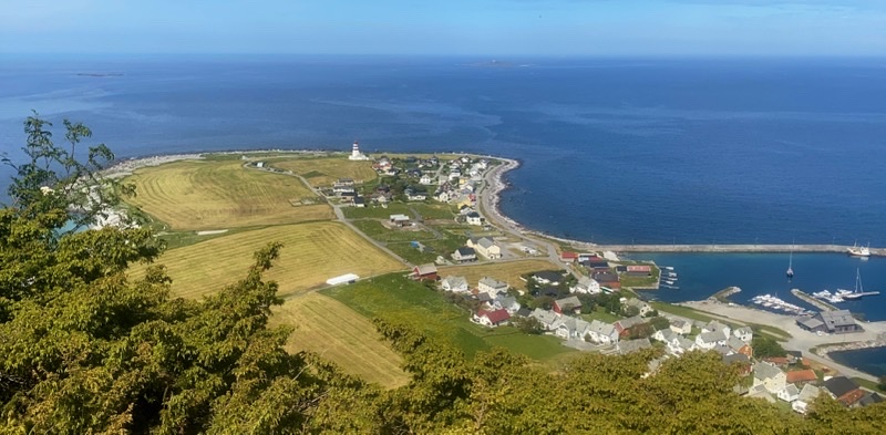
Our 85 minute journey back to the hotel began. One reason it takes as long as it does is that bus 32 takes a 20-odd minutes break at Juv Snuplass (where we began). I’m not sure why this is done. There doesn’t seem to be anything there. If the bus takes a break in Alnes I am not aware of it and that at least is a tiny village. But the break did give us a chance to get out and get some much-less-hazy pictures of the islands south of Godøy. This is when the bus driver told Dad that the extremely pointy peak was called something like Sugar Top. It’s an odd name as there is no snow capping the mountain peak providing the sugar.
I could go on and talk a bit about the lady who was waiting with us at Alnes for the bus while her husband tackled the walk we had just done going in the other direction. We had a modest conversation while we waited. Her husband would link up with her later in the bus ride though not at Juv Snuplass so he found a different route down which means his walk was a bit different from ours. I could talk about the chat Dad had with the bus driver too. If you’re willing to talk with people they talk back. Dad is good at that.
When we got back to the hotel it was 17:23 and we had an hour to get ourselves ready for dinner at restaurant Bro. This would be our first of three pre-planned by Inntravel meals. We were scheduled to have a 3-course meal and that is about all we knew. When we arrived we found the outside teaming with people having drinks and perhaps eating. Given the price of tonic water (about $5) to say nothing of beer ($12) your drinking budget could explode pretty quickly. Inside we found the place for less busy and we settled down at a waterside-view table for dinner. Over the next 90 minutes, an age for us, we ate our very enjoyable meal. My starter ws an asperagus in butter sauce with very small shrimps dish. Mom and Dad had some type of gin-cured mackerel also with plenty of herbs. The restaurant had to make a change for me on both the starter and main course as I definitely can’t eat chicken or fish. My flat iron steak was well presented, reasonably cooked, and flavored in a buttery herb sauce that was quite good. The hassleback (?) potato was nice if a bit salty but I think I’ve gotten spoiled by my smoked baked potatoes. Mom and Dad had Plaice Fish which they both enjoyed. The rhubard dessert was a donut like bun with rhubarb jam inside. Served alongside was a parfait of ice cream, nuts, and a local berry of some type. The combination was lovely. Maybe we will have to return to Bro just to enjoy a dessert on the remaining day we have to find our own dinner. It was good to end the day on this high note. Stats: The hike was 4.8km long with 235m ascent mostly in 1 kilometer; 280m descent mostly in 1 kilometer. The ascent and descent trails are quite steep and the descending trail is pretty much all rocks.
Photos
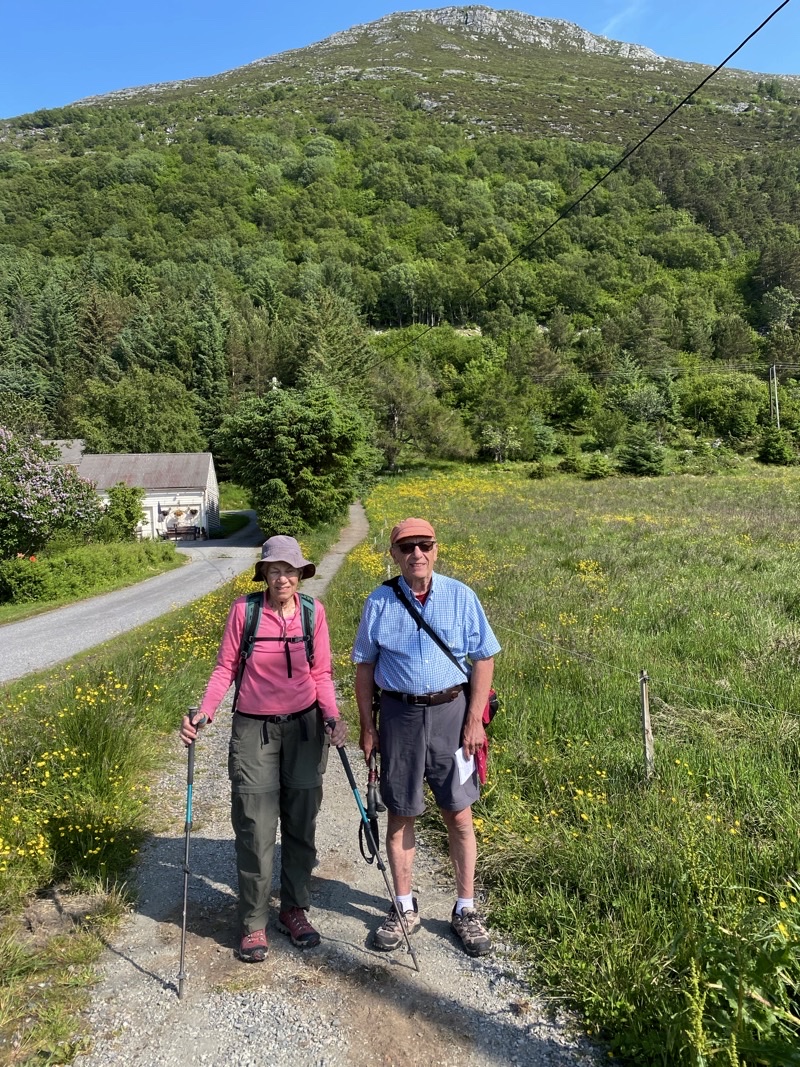
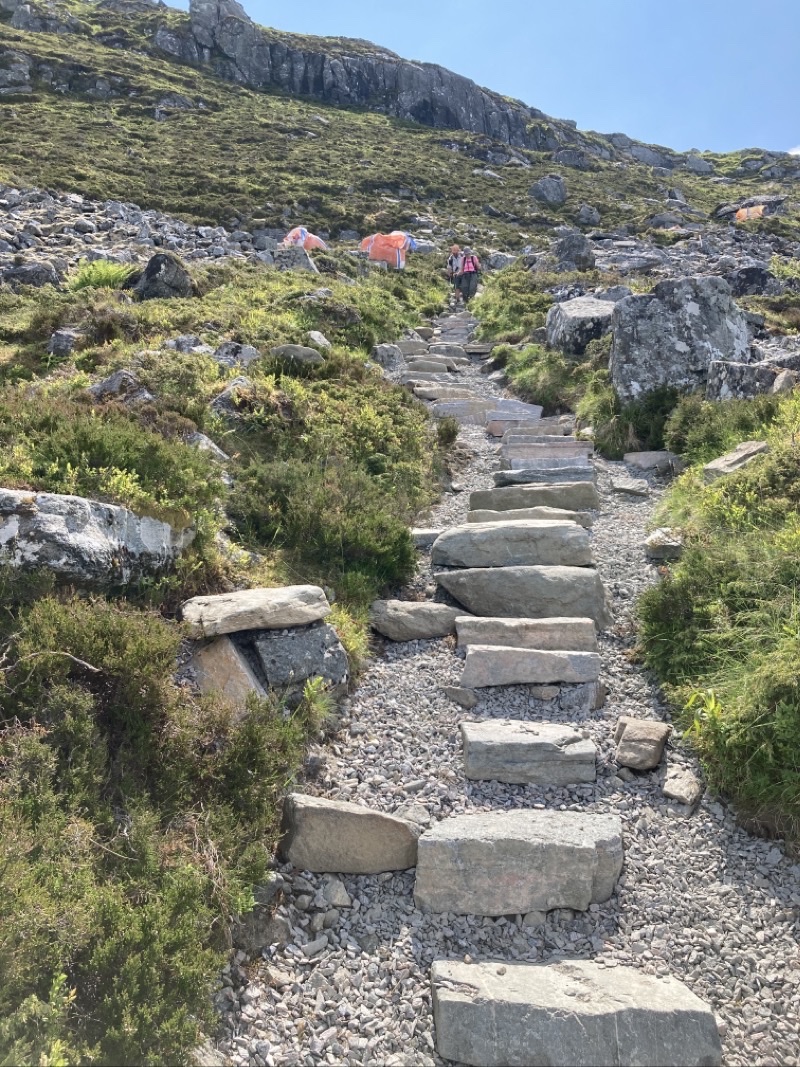
Our hike is going to start with this climb. The notes say it is a rocky and steep trail. It sure does look like it.
—June 19, 2023 at 9:54 AM.
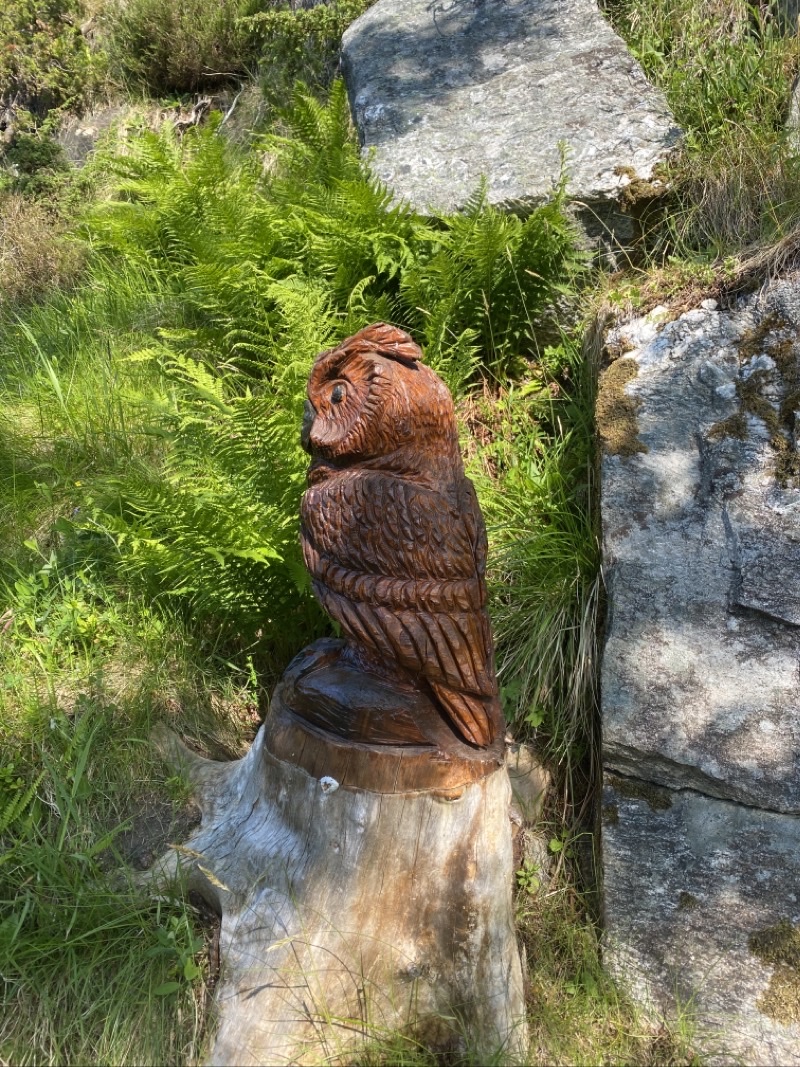
The flies are swarming and this owl is doing nothing to help us. We continue to plod up the somewhat rocky and steep trail. THe footing isn’t great but it isn’t awful either.
—June 19, 2023 at 10:12 AM.
One of the few places with a view during our 1-kilometer long ascent. We have been climbing for almost 40 minutes and ascended about 155 meters over perhaps 750 meters of trail travelled. We have taken a few breaks. We might have taken more breaks to catch our breath than we did if it weren’t for the ever-present swarming, not biting, flies. Annoying, irksome, bothersome, but at least not eating-us flies.
—June 19, 2023 at 10:27 AM.
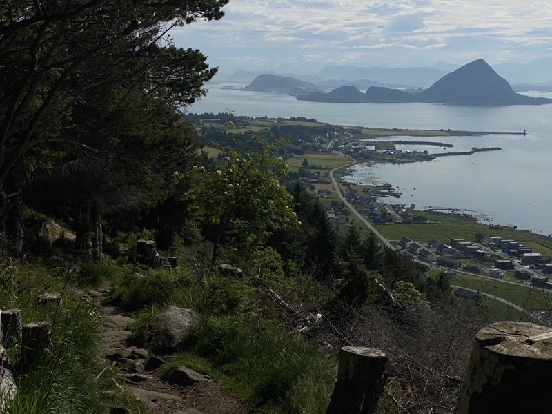
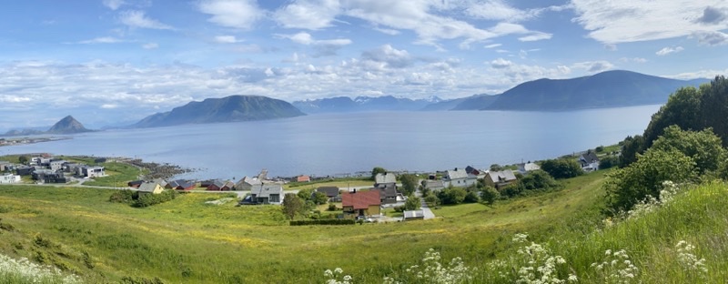
The trail opens up here and we still have a few hundred meters to go to reach a shelter. The wind was blowing a bit and that helped knock the flies back a little bit. A very little bit. Dad and I got to the top a couple minutes before Mom. I think we all felt the climb. We wondered what the descent would be like as it looked like it had a similar level of steepness. The views would have been spectacular except for the hazy sky. The pointy mountain on the left is called something like Sugar Top though it doesn’t have any snow sugaring the top. We have been ascending for an hour, hiked 230 or so meters over just over 1,000 meters of hiking from where the trail really got steep.
—June 19, 2023 at 10:51 AM.
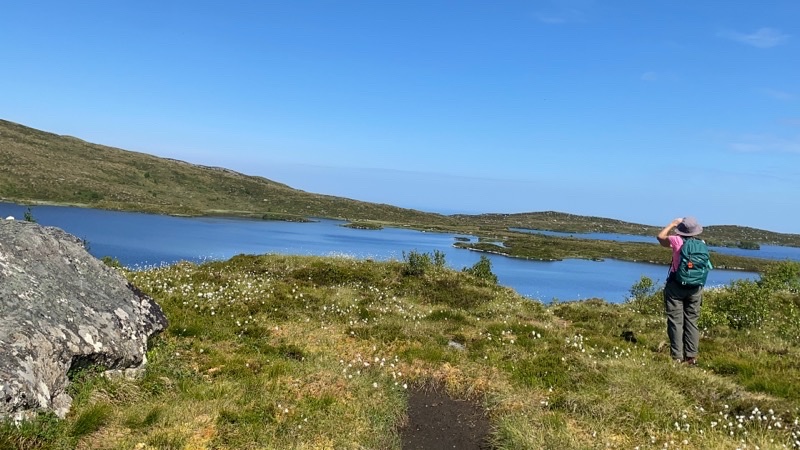
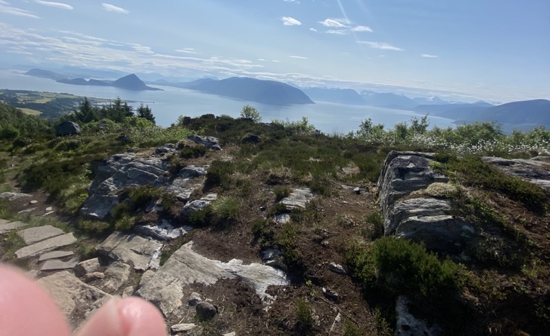
I am not sure if we should call this an alpine lake or not. We are now above treeline in this area. We are at 276 meters above sea level and I think we will navigate around the lake for the next 2 or so kilometers. I do not know why swimming is prohibited which is a little sad as taking a dip after sweating our way up here would be tempting. Under the bright sun it feels like the temperature has risen above 70 F.
—June 19, 2023 at 11:10 AM.
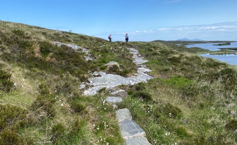
The trail around the lake sometimes moves away form the lake. What makes the trail remarkable is that it is made of flat (mostly) rocks that are placed like stepping stones to form the path on the boggy ground. I am confident that thousands of stones were placed to make the trail. How were they brought in? I think it must have been via helicopter.
—June 19, 2023 at 12:08 PM.
We are about to start our descent to the village of Alnes. It will be along a trail the notes say is rocky and sometimes steep and you need to be sure-footed. We expected to descend about 260 meters but hadn’t checked the distance. We actually thought it might be over 2km as we knew the walk ended (we thought) with a 1.5km roadwalk. Nope.
—June 19, 2023 at 12:44 PM.
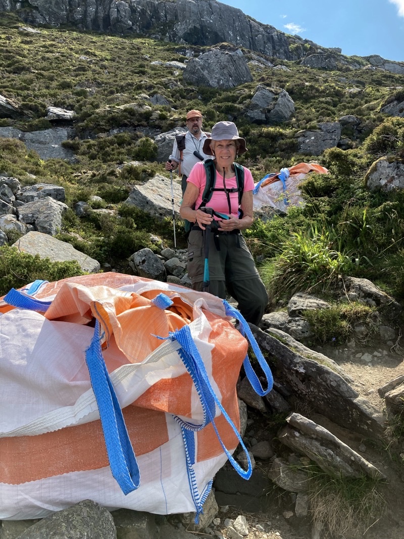
We have been creeping down this steep, rock strewn, real pain of a trail for a half hour. Mom is standing between two huge bags that contain stones that we figure will be laid on the trail to continue improving it. It is a slog. It is not fun. If we are moving faster than 0.75KPH I’d be surprised. Photo by Jonathan
—June 19, 2023 at 1:26 PM.
Looking back up the trail you can get a sense of what we have been dealing with. Ugh. Just ugh. Photo by Jonathan
—June 19, 2023 at 1:31 PM.
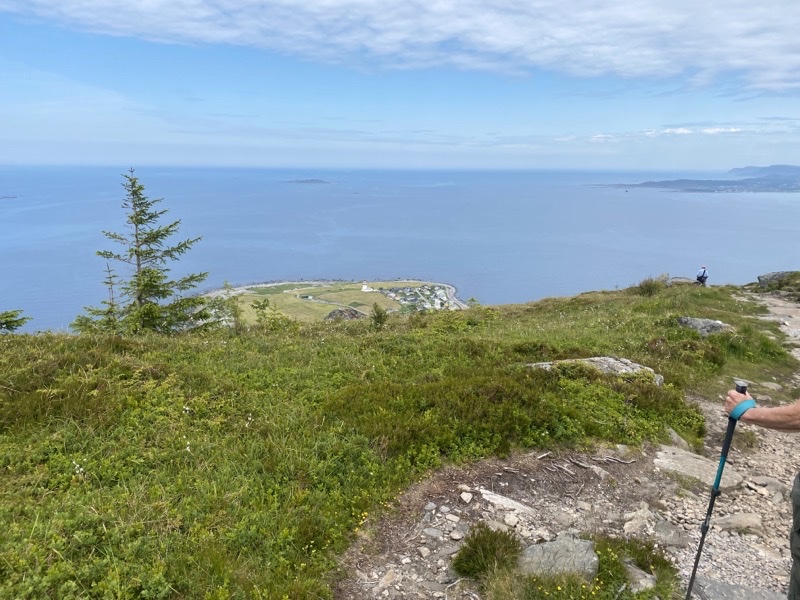
As you can see the views are wonderful but the grind is continuing. We are over an hour into the descent and still have probably 140 meters elevation to drop and closer to 500 meters of trail to contend with. Just awful. Many younger folks have been heading up to the top and some coming down: all so much more adroitly than I.
—June 19, 2023 at 2:01 PM.
We finished the abolutely wretched descent probably two hours after starting it. We then walked the road to the bus stop. It was a bit past 15:00 and we were pretty sure a bus would come by at 15:55 so taking the time to go into Alnes and find the cafe and get a close look at the lighthouse wasn’t going to happen since we certainly didn’t want to wait for a 16:55 bus. We are riding bus 32 back towards the connection point at Ytterland. However, along the way we would pause at Juv Snuplass for 15-20 minutes (planned stop) and I was able to take this photo. The whole journey took about 85 minutes so you can see why we didn’t want to catch a later bus.
—June 19, 2023 at 4:13 PM.
No comments:
Post a Comment