Sunday, July 29, 2018

Maine morning

mom and at Ocean Point resort

Good morning from Ocean point resort. Our first day of kayaking started out sunny and then the fog rolled in. By the end of our 12 km kayak the fog was  thick  and the air was hot and moist. A bit spooky on the calm water (swells earlier)  the tolling of belled  buoys and blasts from a ferry’s foghorn and breakers on an invisible shore. 


This morning yhe clouds and fog have left. 


Wednesday, July 4, 2018

Wicklow way Day 5 - Cronewoods Parking Lot Area to Eden House Pub

overview map. Cronewoods to the end

Today is our final day on the Wicklow Way and we have been told that it is supposed to be a pretty section of the Way. We took a taxi to just beyond the parking lot, to avoid the 2.5 km walk on a narrow paved road, and hoisted our packs at 09:10 under once again clear blue sky.


We quickly joined a path that would run alongside of a river for a time before curling around fields of bracken for a kilometer or so. Pretty walking and apparently popular too. Too bad it would not last. Soon we found ourselves making a short modestly steep ascent up to a forest road which we would follow  along with our attendant hoard of sometimes-biting but alway annoying flies. The most interesting thing about this stretch of trail were the three horse riders we passed heading in the other direction. 


We passed by, or near at least, a hostel that is definitely used by walkers. We had met a couple heading in the other direction already and soon would catch up with a troop of English scouts who had stayed there the night before and were also heading in our direction.  We had been walking either forestry roads or minor paved roads now for upwards of 5km.

Last biew of Wicklow Mountains
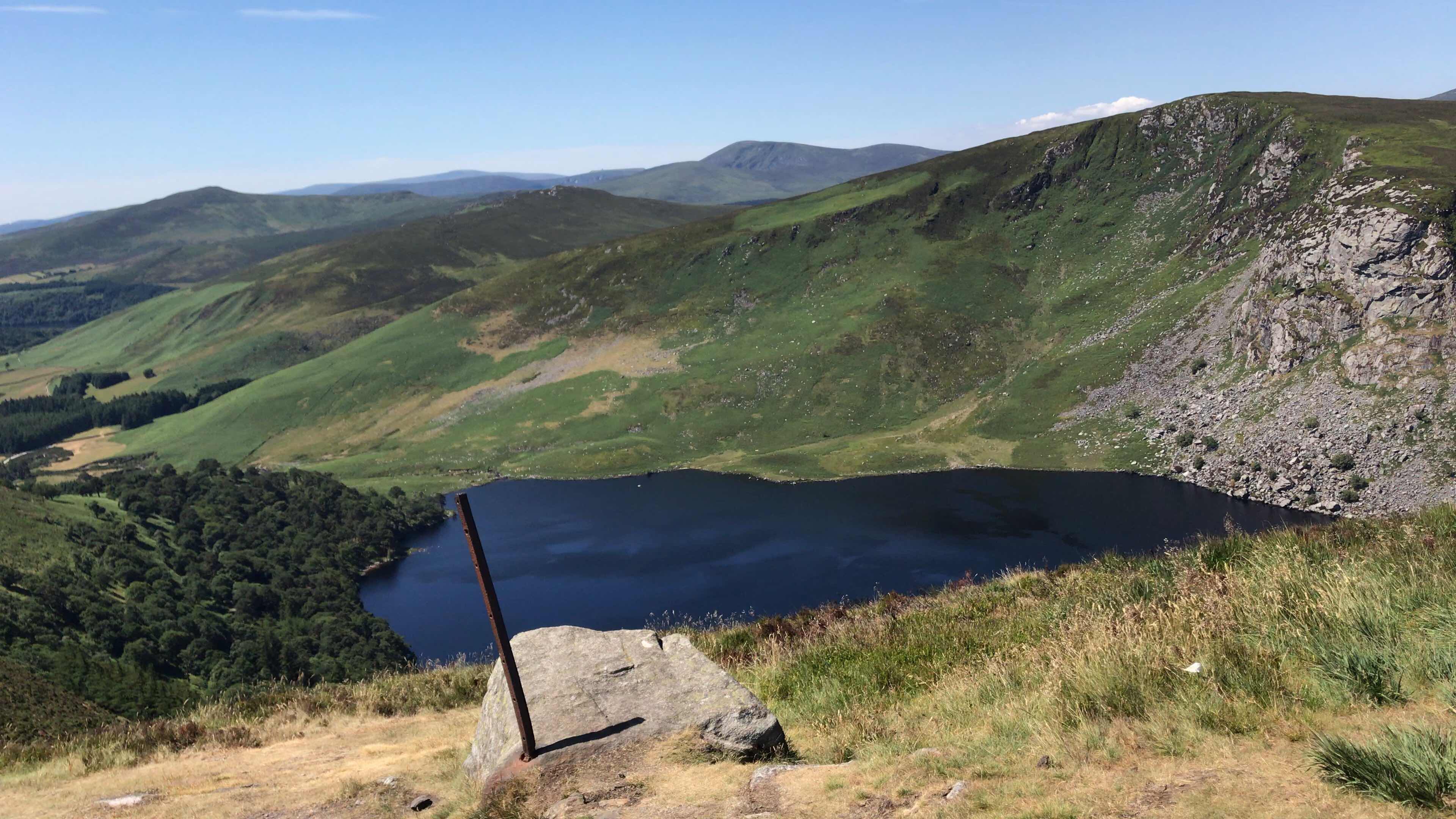
We entered, I believe, Charlestown woods and began a steady gradual ascent along more forestry road. This forest has been denuded to a degree so isn’t that pretty. You get a view now and then looking back to the Wicklow Mountains and ahead towards Dublin but it’s not great. Worse today because it was hazy.  The forestry road would take us to a stretch of rocky (big boulder steps)trail that slowed me down a lot. It didn’t bother the trail runners who zoomed on by heading down. It isn’t precisely hard just slow going as you step from large rock to large rock over a stretch of a few hundred meters. Views would appear now and then but I am sure we were expecting better as we approached the top.


As the rocks came to an end they were replaced by gravel path with big  gaps seemingly every 20 meters. Most people will just step over them with a smile.  I had my usual pause, plant pole, step over, and keep going style of travel. Along this stretch of a kilometer or two we saw many people out for a day walk. It is easy walking but not really all that eye catching.


Off the top and on to another forestry road and down we went. The sky had actually clouded up a bit and a tiny nip was in the air. Not enough to really be a bother but a change in the weather we had been seeing. We  continued on down, decending gradually, and leapfrogging with the scouts and a French lady we had stayed with at Coolakay House. Down and down. 


The Way would eventually pass over a stream, we had been wondering when, and we would start moving through farmlands and more prosperous seeming places for a time. That forestry road would end and we would begin a long slog along first a quiet and then, for much longer, busy paved road. The directions let us down here.  Perhaps we just read them badly but we walked along that nasty road for something like 1.8km. This is an awful bit of WIcklow Way and I hope they come up with a way to get it off the road.


The climb away from the road towards Fairycastle is nice enough as it follows a gravel-based path that has some rocks scattered about for good measure. You get some vistas though they don’t really count as eye candy. It starts with a steady modestly steep climb but soon levels out as it crosses the tops. Breezy and cooler up there as well as popular.   I enjoyed the level bits and ascent but the gradual descent had just enough chasm-sized gaps to slow me down and be annoying.  As we neared the end of this bit, somewhere around kilometer 16 of the day, we had been hearing the roar of the M50 for a while. That is sad. 

heather fields of Fairycastle

Dublin and the Irish Sea
It’s a shame you have to pound down the forestry road from the end of this path for a good 1.5km to reach a carpark where I am sure many who do the hike as a day trip park. It is enough of a descent that you notice it and would really feel it on the ascent up. 


The Wicklow Way continues past the carpark  soon joining a minor paved road and then bigger paved roads.  The M50 roars in the dsitance and we push on and on along the paved roads. 3.5km and more along the roads to Marlay  Park where the directions are less than ideal for helping get you through  the park. To be brutally honest if I were doing this again I would try to get a taxi at the carpark and call it a day and end of hike there. Those last 3.5km or so sucked. Why Sherpa/Footfalls has us end at Eden House is a bit of a mystery. I suppose it is because it is a pub and taxis can find it easily. 


This last day was nothing special. I am glad it  wasn’t our first day. The slog on the paved roads and then steady climb up the forestry road to the path that then leads to the Fairycastle tops would have been a real drag. That portion, to be fair, is quite pretty and it is open and covered in heather.  While not in bloom the heather gives the space a soft look. 


Marlay Park is a nice park and clearly a place where many things from families having fun to major concert events take place. I think we would have enjoyed it more if we hadn’t first had to plod under and past the M50 for so seemingly long a time. The group of food trucks though with one selling , a bit overpriced, ice cream though was a welcome surprise which we took advantage of.


Stats: 22.4km. 600m ascent; 650m descent. The climbs come in two big hills first to the Charlestown woods tops and Faircastle tops. Descents are off those tops with the biggest being after Faircastle. A couple of short modestly steep and rocky bits but generally easy going. The 1.8km paved (and busy) road walk just before you ascend on path to Fairycastle is no fun at all. Weather: Mostly sunny with a bit of overcast now and then. Highs on the tops were in the mid-70s and warmer down below.


Photos

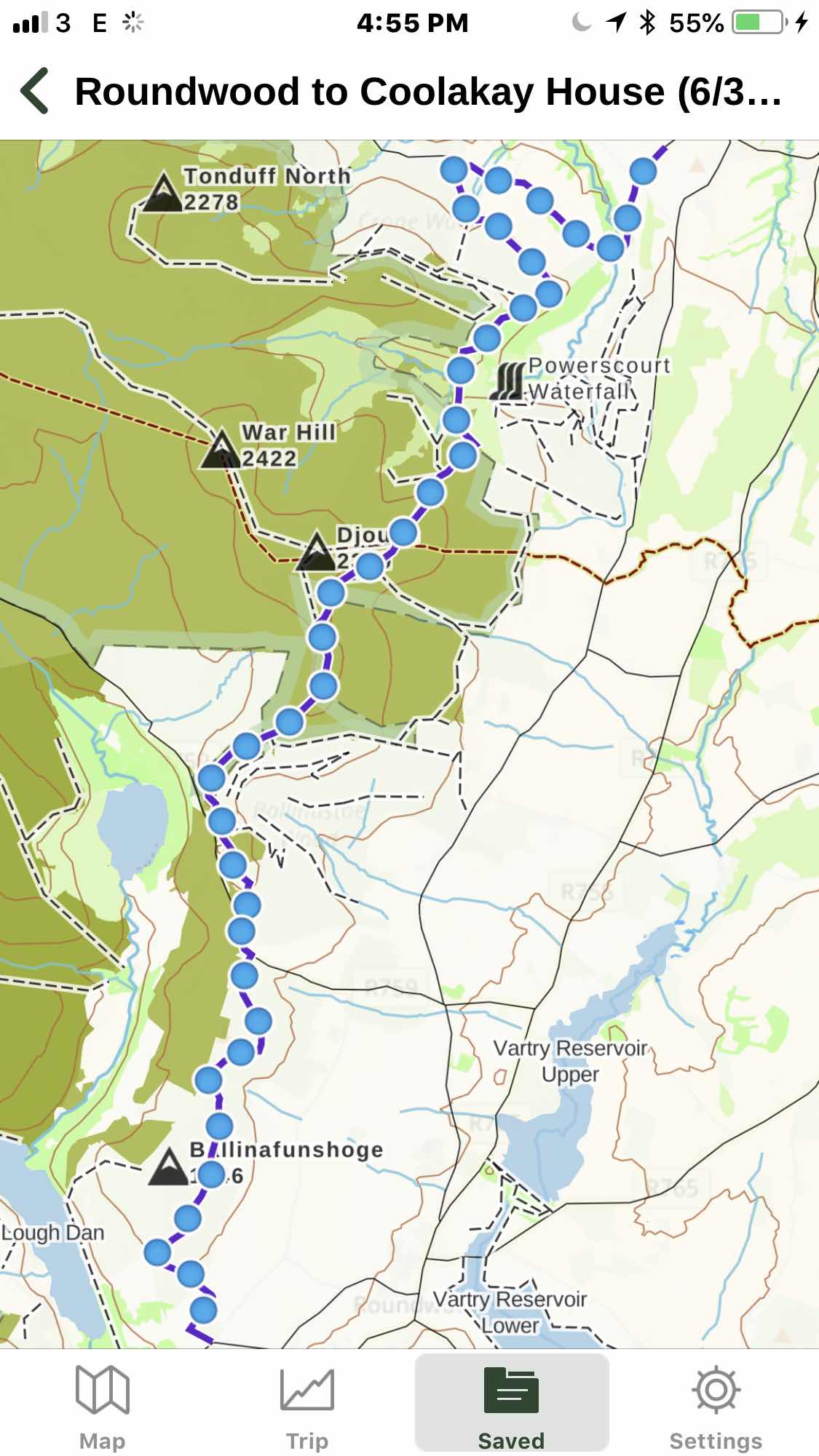
  1. Overview map. Cronewoods to eden House Pub.
  2. Climbing up to the tops of Charlestown Forest (I think) with a last view of the WIcklow Mountains fading into that smoky haze.
  3. The tops of Fairycastle are covered with fields of heather. The trail is hardpacked dirt with rocks now and then and gaps, probably for water and erosion control, sprinkled in along the way. Pretty in its way but if the weather turned foul you would want to hustle off this open country as quickly as you could. The people in the background are some of the young folks out on a scouts trip.
  4. Mom and Dad gazing at our first really good view of the Dublin Mountain and outskirts of Dublin. Too bad we could hear the roar of the M50 while we look out towards the city and Irish Sea.

Sunday, July 1, 2018

Wicklow Way Day 4 - Roundwood to Coolakay House

overview map. Roundwood to Coolakay House


Our unusually warm and clear weather is continuing. We , along with another couple, piled into a car to be driven to Roundwood . This was an unexpected change in our plans that we had learned about the night before when we arrived at the Riverside B&B. By shuttling to Roundwood we would skip about 4km of roadwalk on admittedly small tarmac roads but roads all the same. Purists will no doubt decry our skipping this bit but we aren’t purists and we aren’t even doing a through-hike (sorry thru-hike).  Driving the narrow twisty roads is an experience in its own right so we just got something a bit different to enjoy. At 09:40 we hoisted our packs onto our backs and set off on the Wicklow Way bound for Coolakay House about 19km away (16.5km on the Wicklow way).


Easy walking along a lane and then through fields with many bales of hay. Gradually ascending as we went. It was enjoyable going. The 3km of forestry roadwalk with views looking down on the reservoirs near Roundwood that help supply water to the southern areas of Dublin was also nice enough. Maybe a bit bland but nice enough.  We started encountering people out for day hikes as we headed onward. This is clearly a popular area though I suspect being a Saturday and a lovely morning doesn’t hurt. When we reached a busy paved road , R759, we found quite a few people and parked cars in various little lots strung along the route.   Dad probably left his knife there after using it to cut some moleskin for a hot spot on his baby toe. (We just discovered this loss when looking to cut our baguettes for today’s sandwiches.)


Maybe everyone was heading to the same places we were but we saw paths leading off in other directions too so we just don’t know. Our route took us into deep dark, seemed to be a common theme, forest. The trail follows an old sunken lane gradually ascending through the trees. The trail uses boardwalk in this section. The boardwalk is, once again, studded with innumerable studs in a mesh. I suppose the combination of aging boardwalk and mesh gives it the rubbery feel because the studs are akin to giant metal staples. I still don’t like this type of anti-slip set up.  However, walking through the dark forest was quite nice.


We popped out in a denuded area that while void of trees was full of fields of heather on either side. The gravel path was easy to follow and it gently dropped us down for a time. Big views of open countryside as the morning wore on and the wind seemed to increase in intensity.

Lake Tay

boatdwalk forever
Soon we were at the next stretch of boardwalk. This section, easily 2km in length, would take us up and up and up. We would pass by the J.B. Malone Memorial Monument where we took a break. We would gaze out towards Lake Tay.  Look out on lands that I think were once home to some of the Guinness family (maybe still are). Listen to the dozens of people chatting who were also walking the endless boardwalk. A great midday under clear blue skies with moderate temperatures in the mid-70s and a breeze brisk enough to actually make you feel cool. If the weather turns foul up here around White Hill it would be bad indeed.


The boardwalk continues up and over for quite a lengthy stretch.  But in time does come to an abrupt end. At this point we began descending into the teeth of the breeze. Working our way down Djouce mountainside. The path at this point gets quite narrow, perhaps 12 inches wide, and is certainly the most “trail-like” we have seen so far. It is also quite busy with people going in both directions. 


Another stop to eat a bit more lousy lunch food (a definite weakness these past few days) before continuing our descent on the trail to a forestry road that would drop us steadily, ruts and all, down towards the Dargle River.  That road would end with us joining a path strewn with rocks that dropped more steeply to the Dargle River itself. Not particularly pleasant walking but at least the scenery was good. In fact, this day has had the greatest variety of scenery and hiking conditions so far and that helps make it a very good day indeed.

Ken

Mom

Dad

Dargle River vslley

It took between 7 and 8 minutes for Dad and me to climb the couple hundreds meters of trail to the top where Mom was waiting for us. She got a head start on the downhill. From there we would have one final long descent along path and forestry road that would lead in and out of lovely forests affording us occasional views of Powerscourt Waterfall. This was something more heard than seen. The water rumbled on down and we heard scores of voices in the distance. People playing at the bottom of the waterfall. Too bad our hike didn’t take us in that direction because I bet it was nice down there. Instead we pushed on along the road through a recently burned, just a couple days ago, section of woods. We had seen forest fire earlier in the day burning way in the distance too. Down we went. The temperature rising and the wind quieted. We felt our energy levels ebbing as  we approached the carpark, Cronewoods car park,  that marked the end of the Wicklow Way part of the hike. It was probably about 16:10 and plenty of cars and people were about. In fact we lucked out big time here.


We still had 2.5 to 3km to hike along narrow tarmac roads to reach Coolakay House. A taxi pulled into the lot and let some walkers out. Dad went over to see if the driver would take us to Coolakay House. He was willing and we got in. What a stroke of luck because I suspect walking those last couple kilometers would have been a real drag. But it did throw off the GPS track I was recording so my stats aren’t quite ideal (minor gripe indeed). This was a lovely day to be out and I can see why this portion of the Wicklow Way would be popular among people out for a day.


Stats: 16.5km hiked with about 450m ascent and 550m descent. With the exception of the steep bit out of the Dargle River valley everything is pretty gradual. Th descent down to the Dargle is rocky and a bit steeper but not really bad. Weather: clear blue skies all day long. On the tops with the wind blowing around 15MPH you could feel a bit cool as temperature were in the mid-70s. I wonder if that touch of coolness in the wind was from the Irish sea that we could spot way off, perhaps 10-12km, in the distance.


Photos

  1. Overview map. Roundwood to the Crone Carpark. Generally heading south to north.
  2. Mom and Dad in the hay bale strewn field.
  3. A view from the J. B. Malone monument.  Lake Tay below. 
  4. The boardwalk that seemed to go forever. 
  5. Lunch spot on Djouce Mountain slope.
  6. Ken. Nearing the Dargle River. Photo by Mom. 
  7. Mom in the same place. Photo by Dad. 
  8. Dad at that place. Photo by Mom. 
  9. The thin line is a portion of the Wicklow Way we just descended to the Dargle River. The climb out is about 300 vertical feet over at most a quarter mile distance but lijely less. Photo by Mom.