Saturday, June 30, 2018

Wicklow Way Day 3- Glenmalure to Riverside B&B

overview map. Glenmalure to RiversideB and B

If their was anything really active and noisy, like live music, happening during the evening at Glenmalure Lodge none of us noticed. I fell asleep before sunset. I had to contend with being awake for a time in the middle of the night but I still slept quite well.  We had our hearty breakfasts at 08:00 and shouldered our packs and were ready for the trail by 09:00: a good start given the timing of things. 


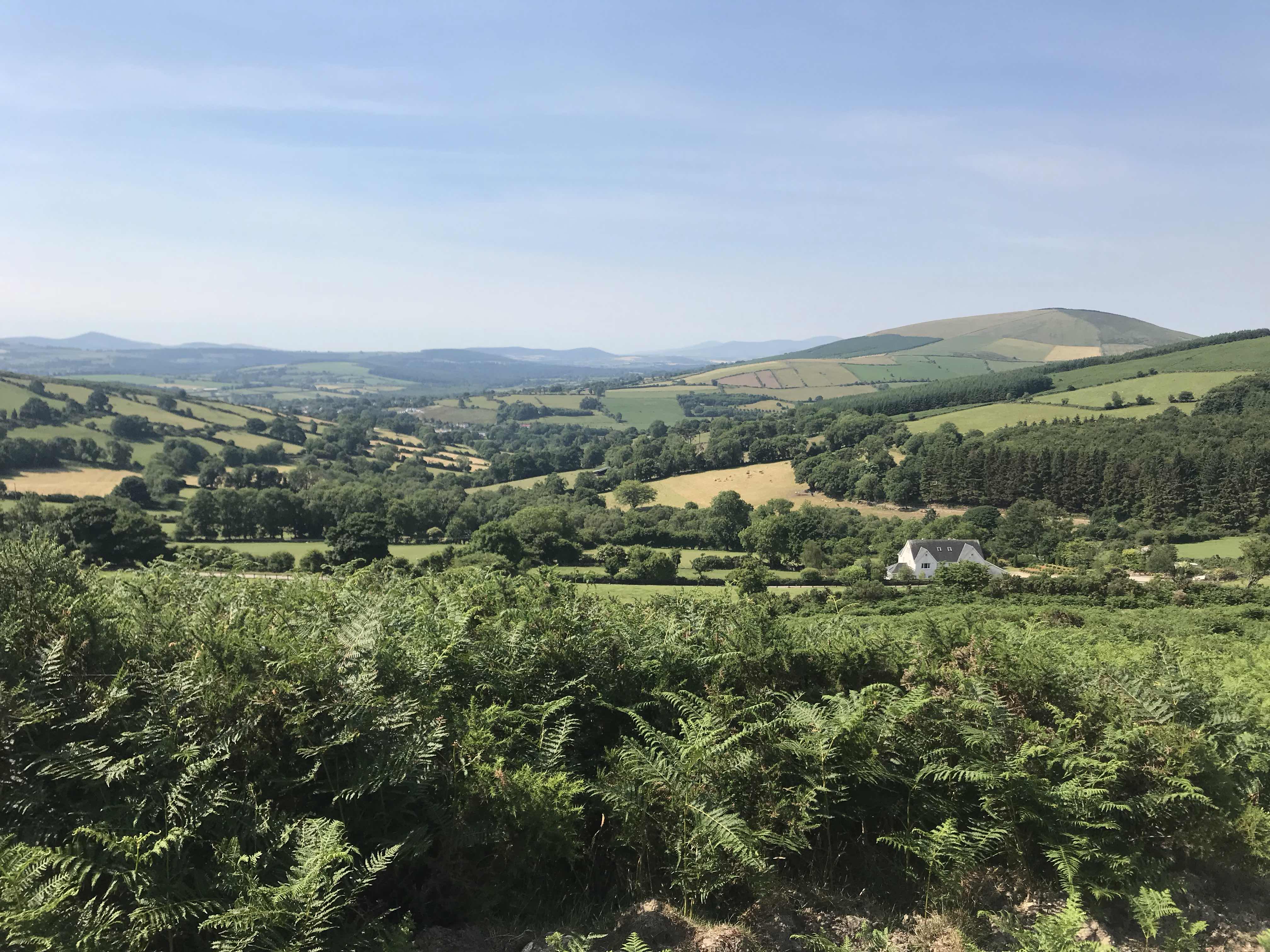
We said goodbye to the 2 Dutch couples, clearly quick strong hikers - just look as those long legs, who would catch up and pass us in short order. We left the lodge under clear blue skies that promised, yes again, superb weather that would be on the warm side. The Wicklow Way would wind its way gently along forestry roads through forest that while managed  seemed much prettier than the sections we had walked yesterday afternoon. Maybe we just felt more energized too but it was an enjoyable walk.


We even had some big views though they won’t really stand out  as stunners for us. Glenmalure waterfall could be heard but it didn’t look like much as it tumbled down. In fact, we could see the Zig Zags Path that an Irish landlord had constructed not far from the waterfall for use of his friends to reach a lake where he and they would go fishing and hunting far more distinctly. As a change in scenery it is nice but if you are expecting a take-your-breath-away moment you will be disappointed. 

climbing a path on Mullacor
Eventually our forestry road walk would come to a two-track (about 4.5, or was it 5, km) and that would lead in time to an actual path up a steep slope of Mullacor Mountain. Nice change of pace followed by boardwalk that Mom and I do not like because it is covered with that supposedly anti-slip bumpy rubbery stuff that leaves us feeling less safe. Dad doesn’t mind it. A few hundred meters of that crap and we were back to a forestry road  and gentle descending. A good place for a morning break even though we did not really have anything good to snack on.


The next several kilometers would continue along forestry road with some rather lengthy stretches through ugly stripped forest. A slog Of 6 or so km that while not hard was dull especially when we knew we were nearing, as the crow flies, lakes that were reportedly quite pretty. Poulanas Waterfall, passed by on a knee-twinging (yes it still bothers me on descents) paved trail was nice enough. The sounds of voices drew us steadily down towards the Upper Lake. Numerous paved and gravel paths twisted about and around this good-sized lake with small beaches and many fields for playing in. Lots of people were doing just that. We found a shady spot on the rough beach and settled down for a lazy lunch. A good spot. If the snackbar, we saw at least one fellow with coffee and learned ice cream was available, had been closer we would surely have succumbed to the temptation of food that would have been tastier than our mediocre sandwiches.

View of Upper Lake

poulanas waterfall
lunch at Upper Lake

Monastic tower and home

A paved path joins the Upper and Lower Lakes. The Lower Lake is smaller and doesn’t have beaches. I suppose that is why people were not skipping stones and playing like they were at Upper.  An old monastic city, a home for monks at least, stands near the lake but we didn’t go down for a close look. The tall pencil-shaped tower looks like something from Repunzel’s story. At least it would have had a lake view.  We left the two lakes behind and quickly came upon a roadside hotel. They had an open bar so a quick drinks break (fanta and a local red ale) was called for. We weren’t in a hurry after all and we had a climb to still do.


That ascent wasn’t nearly as bad as we though it would be and the subsequent 2km of hiking was among the nicest of the day as it wove through forest along an old two-track that was closer in many place to simple path than road. Of course, that would end dumping us out on a forestry road by a spot that’d make for a good campsite if it had water. Down we went to a different forest which was also rather nice and after a half km or so dumped us out on a minor paved road that would take us off the Wiclow Way for a km or so into the village where the Riverside B&B is located (1.5km off the way). 


The notes suggest this is the prettiest section of the hike and it certainly was nicer than day 2. I hope it doesn’t mark the pinnacle of prettiness or that what remains is comparable because we still have two days and about 50km to go.    By the way, the B&B is nice enough and though we were not thrilled with the 500-odd (felt like more) meter walk back into the village for dinner our meal at Lynham’s (sp)  was pretty good. Early to bed again and I am finishing this not long after sunrise and the never shutting up roosters have made respective visual and audible appearances. 


Stats for day 3: 19km with about 550m ascent and descent. Most of the ascent happens on gradually climbing forestry roads in the first 5km with a steep bit on pathway between 5 and 6km. Descents are gentle and even the steep descent past Poulanas Waterfall wouldn’t bother anyone whose knees are healthy. The remaining ascent and descent (just past the roadside hotel) aren’t that rough. Weather: clear blue skies all day with virtually no clouds and a high around 83F. We took 1 hour 18 minutes in breaks and were moving for about 5 hours and 56 minutes.


Photos

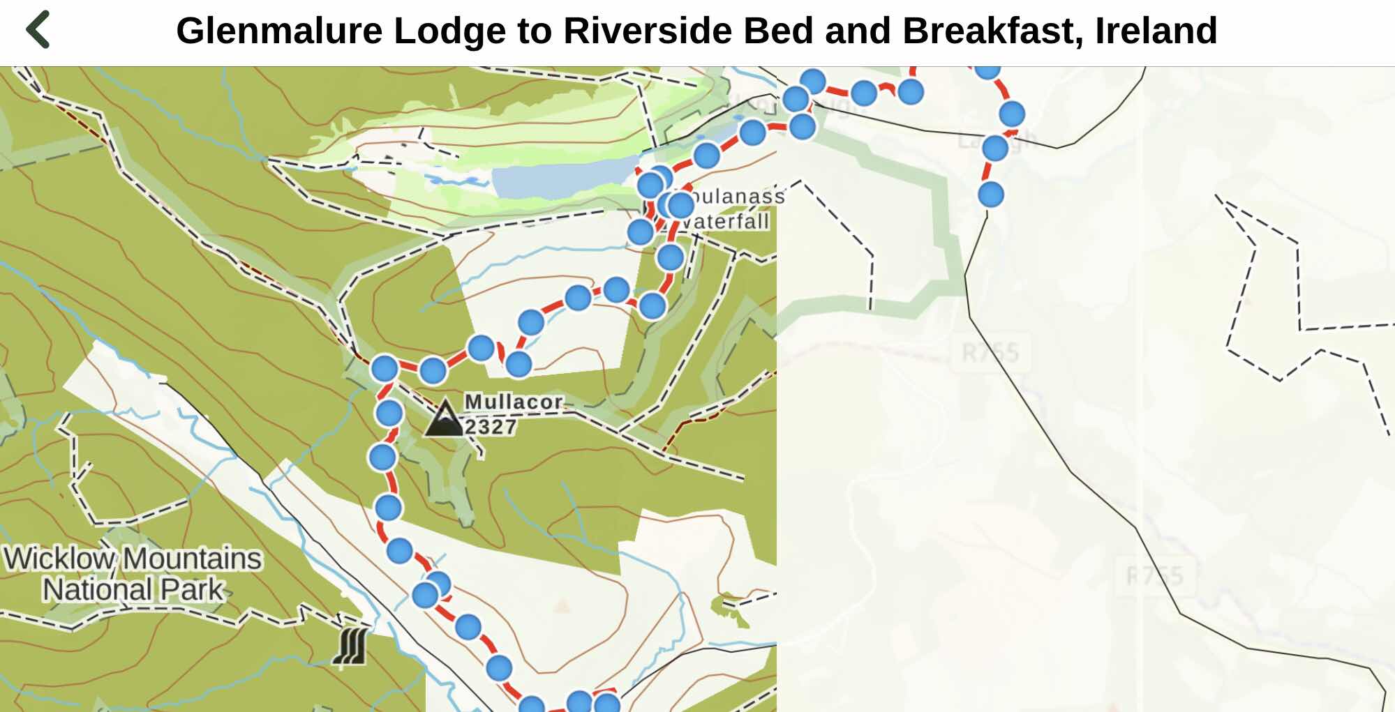
  1. Overview map. Starting at Glenmalure Lodge and ending at Riverside B&B.
  2. After 5km of gradual ascent on forestry roads we are climbing up the side of Mullacor mountain. It is a path of big rock slabs but the footing is good. Tiring though.
  3. Hurray. Upper Lake is in view. It it still a good 20 minutes walk, seemed longer, away.
  4. Poulanas Waterfall.
  5. Our view from our lunch spot at Upper Lake. Odd I thought we spent longer here at lunch but it wasn’t even half an hour.
  6. The tower and home, part of what our notes call a monastic city, sit not far from Lower Lake.

Friday, June 29, 2018

Wicklow Way Day 2- Shielstown Forest to Glenmalure Lodge

overview map stRting at Shielstown, headong north, to Glenmalore

Our streak of cloudness warm mornings continues. The Irish probably consider this run of weather a heat wave and when you are walking along a shade-free road it is easy to agree with them. Today though we would have a fair bit of shade to help keep us feel a bit more comfortable as we walked from Shielstown Forest, where we left off the day before, to the lodge in Glenmalure some 18km away.


We started out by strolling along a forestry road that wound its way back and forth and steadily up through the managed forest of Shielstown Forest.  Our understanding is most of the trees are Sitka spruce but no doubt other species are mixed in too. While you are walking a dirt road with forest to either side it is not a bad walk when you are walking in areas  that do not show obvious signs of cutting. Of course, that never can last in a forest that is being actively logged and we saw evidence of clear cutting.  We ascended gradually over a ocuple kilometers before gently descending a smaller forestry road with a stream running alongside. Easy walking as we crossed the stream and joined a minor road for a bit and continued to slowly descend working our way towards another river bridge crossing. This is easy walking but it is walking along country roads and so a bit dull. 

Mom an Dad

We were at the 6km mark before we really hit a stretch of walk you could consider being on a path. A steeply ascending path that followed a powerline right-of-way up a hillside for 400-500 meters ascending easily 60 meters over that stretch. By now the shade had lessened and the climb brought out the sweat. It was warming up and I’ve no doubt that the temperature under the sun was pushing 80F by late morning.


More road walking through more managed forest. We passed a runner with a support van doing something for charity. Poof: he was gone.  We kept ascending for the next 1.5-2km and around 11:20 we reached a lean-to shelter that sits in an open area a few hundred linear meters below the sumit of Carrickashane MountIn (sp) and would make a fine place for an emergency or, given it has a fire ring and maybe water, a decent campsite shelter. A good  place to sit at the picnic table and have lunch. It is too bad the food provided for lunch was rather pathetic. No one ate even close to everything we had. 

mountain leanto


Up and over the mountain on a path that would lead us down a lovely spruce-needle covered trail for a time before joining yet another gravel and dirt road under blazing sunny skies.    We continued down , joining a tarmac road for a short ways, before veering off on to a field path that would wind into a new managed forest and join another forestry road that would climb into the Slieve Mountain forest.  Pleassant enough if a bit uninteresting. Still we found a spot for a snack just before leaving the shade to begin the final ascent of Slieve before dropping down into the valley of Glenmalure.


That is a descent that is emminantly forgettable. The first kilometer or so follows the forestry road through wretched looking clear-cut. Ugly. The forest re-asserts itself a bit but it is still not pretty. Here we made a mistake. We missed a turning and kept descending the forestry road to the Military Road. That road is a paved road that keeps descending into Glenmalure for kilometer after kilometer: 5km in all. Somehow we missed the official turn. Looking at the map though we aren’t all that certain our goof cost us any distance and the gradient may have been gentler though the footing grew tiresome.  Sometimes the signage marking turns leaves something to be desired.


A bit before 15:00 we arrived at Glenmalure Lodge. I think we thought we would have a town to check out too but that doesn’t seem to be true. The lodge is a big place and clearly a gathering spot. We settled in and now after a few hours and an early dinner it is time to just take our ease and get ready for toorrow. 


Stats: 17.75km distance with 490m ascent and 645m descent much of which climbs up and over Carrick-a-Shane and Slieve Mountain before descending into Glenmalure. Vast majority of the walk is forestry roads with a bit on paths. Had we not made our error the 5km final tarmac stretch would likley have followed more forestry road. Weather: clear skies all day with a high pushing 84F.


Photos

  1. Oveiew Map. Starting at Shielstown Forest ; ending Glenmalure Lodge.
  2. Mom and Dad at the highpoint in Shielstown Forest.
  3. A lean-to along the Wicklow way: lunch spot.
  4. What a few hundred years of human activity, with a focus of active forestry in the recent decades, can look like.

Thursday, June 28, 2018

The Wicklow Way day 1 - Tinahey to Shielstown Forest (staying Jyle’s Farm)


overview map. start in Tinahely heading north to Shielstown Forest


Let’s get this out of the way right off: we are not doing the entire Wicklow Way. The entire trail runs about 82 miles and we are doing about 60 of them leaving off the southernmost bit. Our section hike will require five days which will be enough for us to enjoy the journey.   We arrived in Tinahely mid-afternoon and quickly came to the conclusion that there is little to do in town. We made a quick exploration and settled back into our rooms at the B&B to relax before dinner at Connor’s pub. An early evening for everyone.


The morning dawned clear and with the promise of great, for Ireland, heat. We got ourselves on the trail at about 09:30 and were soon leaving the roads of the village of Tinahely behind. Sadly we were destined to return to the B&B because I was pretty sure I had failed to pack some stuff. It turned out I had packed the item but in the wrong place. An extra 1.5km would be added to our hiking day because of this little mistake. An extra bit of time too so our day began again a  bit after 10:00. Oh well. We had plenty of time.


tinahely view

pSgures

According to the somewhat meager directions our walk would be about 14km and follow country lanes, minor tarmac roads , and paths through farm fields. We quickly learned that the directions Sherpa provide aren’t quite as detailed as Inntravel gave us. That might just be for this trip but it is still a shame that they don’t provide at least more distance information. For example, tell us that the hike from the start of the Wicklow Way to the stream crossing is such and so kilometers long. I suppose you might be able to work some of that out with a good map but having the extra bit of information would be a nice touch. Besides, they do provide it sometimes.


The first 2.5km are actually not on the Wicklow Way.  We followed a narrow, just wide for the large tractor ,to pass us not once but twice putting our toes at serious risk of being crushed. A narrow dirt lane indeed. We found the Wicklow Way and soon were following a path through pastures that were home to numerous sheep gradually ascending and then leveling off for a time before dropping down again. Easy walking with just two or three stiles to climb over. Along the way we had panaramic views of Tinahely and other places. We also found ourselves walking past a couple sheep that were not all that long dead in a case or two. No idea how they died.

horses

After passing a small herd of horses that seemed to be waiting for something we returned to country lanes for a while. Fortunately these were sheltered by trees because by this time, late morning, the temeprature had crept well into the 70s and showed no signs of easing off: not a cloud in the sky.


We worked our way up and down through gentle hills past a memorial or two, an old school house, and no doubt much else. Through a set of fields infested with buzzing annoying flies that may have been biting but were certainly annoying as they buzzed us while we climbed the field path  up towards more country roads that would lead us  past the hamlet of Moyne. Our shade evaporated and we were faced with a road walk under the blazing, mid-80s now, sun.  


We encountered a couple coming the other way and learned they were also staying at Kyle’s Farm. They would get there via a trail turning we had passed a couple kilometers back. Tomorrow we will be staying where they had come from today but our day tomorrow will be a good 5km shorter as we are starting it that much closer to our eventual endpoint. 


We pushed on along the road: less than 4km to go in an hour before our expected pickup at the entrance to  Shielstown forest. It turned out to be closer to 3.5km and we got there with time to spare and settled down on rocks in wonderful shade to await our ride. Phew.


This is a lovely little farm with nice rooms, very accomodating hosts, 3 dogs, and not much to do once you arrive.  But that is alright. I am tired and think I will fall asleep easily even though my room is a bit warm. I do wish I could sit outside here in a shadier spot and enjo the slowly setting sun but that is not going to be. I really do not want to go to sleep before sunset as I definitely do not want to wake up well before, like hours before, breakfast.

view from Kyle’s Farm


Stats: Walk 13.5km with an extra 1.5km tacked on due to my mistake. Ascent (offical walk only): 372m, descent 223m.The lion’s share of ascent happened in the first 7km with much of the descent then too. A couple steeper bit like the farm path field just before Moyne too. Weather: clear and sunny all day with a high pusihing 85F in the sun.


Photos

  1. Overview map. Start at Madeline’s B&B  in  Tinahely.
  2. A view back towards Tinahely.
  3. Typical view from the hillside pastures in this area.
  4. Horses. Need I say more.
  5. A view from the deck looking northernly here at Kye’s Farm. Sunset is still 2.5 hours away.

Tuesday, June 26, 2018

County Kerry Day 6 - Derrycunihy to Muckross House


Overview map. start at Derrycunihy Church

The last full day with HF continued the lovely trend of morning sunshine and clear skies. If the forecasts can be trusted the weather will remain like this for the next several days. Our last walk would be the easier walk. The harder walk does the same route as the easier one but adds a climb up and down a mountain adding 2 miles and an additional three hundred meters of ascent and decent.  The easier walk would be about 11.2km  with about 300 meters of ascent and descent generally spread out through the walk.


We got under way at 09:40 leaving the apparently abandoned Derrycunihy Church to walk along a country lane of sorts for a ways before turning off on to a path that would gradually climb up through some woods and open lands (supposedly being re-forested) before reaching a local high meadow between surrounding hills. It is good path and where the ground gets particularly soggy the trail builders have installed very extensive wood-metal walkways that can extend considerable distances. Of course, all good things come to an end.

Mom not far from the long boardwalk

Waterfall. 4km in but 1.5km were a real pain

While the views were expansive and the weather was fine the footing got steadily worse and worse. The trail began to gradually descend and it did so following a path strewn with countless rocks that slow everyone , but especially me, down. It get tiresome having to pay such careful attention to where you place your feet.  The worst of this rocky stretch is certainly over a kilometer long and could have been as much as 1.5km. It’s a drag.  


Eventually the worst is over and though the path continues to gently drop the footing improves quite a bit as you close in on the rushing sounds of a cascade about 4km from the start of the hike. This modest waterfall is a great place to take a break. If you are willing to chance the nippy water you could take a little soak here but be warned this is clearly a popular area. We spent a solid half hour relaxing here and I think everyone enjoyed the break.


The path continues working its way  east towards a dirt road. Once on that road we undulated through several hills  heading northeasterly eventually leaving the open countryside for woods and a somewhat steeper descent on the road to Torc Waterfall. It is here on this road, not long before you enter the woods, that the people doing the tougher walk would head up and then back down a mountain. 

Our group in the hills

Torc waterfall
We saw scores of people during the road walk. If they were coming from the parking lot just beyond the waterfall we were heading for they were hiking over 4km to  get to the Cascades we had just visited. Not a hard walk as the footing is superb but you would think they would carry a little more water and food than we typically saw. 


The descent down to the waterfall is along seemingly endless rough steps just far enough apart that you can’t easily go down them unless you have longer legs. But once you get to the waterfall the view is pretty good. It is also pretty crowded as the car park is probably not even a five minute walk from the viewpoint.  We had lunch down by that parking lot and it really isn’t a place I suggest you eat at. If the breeze had been blowing the bugs would not have pestered us , they didn’t at the waterfall or a few hundred paces further on, but at that spot they were annoying. 


The last 1.8km of the walk follow a walking path that runs alongside a cycle and horse-and-buggy path. You have views of Muckross Lake and start to get a sense of the quality of the estate that Muckross once owned and eventually deeded to the state to create this national park. An easy stroll at this point and we saw dozens of people of all ages enjoying the afternoon like we were doing.


Muckross House looks impressive and I am sure it is. Manicured grounds and numerous gardens surround it. The visitor center is a bustling hive of activity. We had two hours to just relax and wait for the bus ride back to Kenmare. It was an easy day with one tough bit in the middle and a walk full of good things to see and ice cream at the end.


Stats: Sunny with a high around 70F. Distance 11.3km. AScent 260m; descent 320m. Most of the ascent happens early on with undulations after the cascades. The biggest descent is in the forest.


Photos

  1. Overview map. Starting at Derrycunihy Church. Easy hiking for tge first 2km on lanes and gently rising paths that included boardwalks. A good 1.2-1.5km of gentle descent that would be trivial except for the rocks. Then seceral kilomets of path and countryvroad that indulate through hills before rapidly descending through woods to Torc Falls. The gonal 1.8lm to Muckross House follow a walking trail tyat is flat. 
  2. Mom nit lobg before the rock streen descent.
  3. The cascades are a great place for a break.
  4. On the undulatibg country road. M
  5. Torc waterfall.

Monday, June 25, 2018

County kerry Day 5 - Glengarriff Nature Preserve and Garinish Island

overview map

Our second day in a row where we woke up to clear blue skies and a brilliant sun shining down upon us. That made it an easy five minute stroll down to the grocery store cum gas station to get our sandwhiches made for lunch. We knew that the walk, the easier one today, would end with the option to eat at a pub or cafe but we got picnic lunches instead.  The easier walk would explore a nature preserve and visit an island in Bantree Bay while the harder walk was going to climb up a mountain and spend time on higher ridges and boggy land before descending back down towards the sea. It didn’t seem worth the work to do what was described as a challenging walk  with little seeming reward compared against the variety the easier walk offered. 


The easier walkers, most of the group, started out at a road junction  at the edge of the Glengarriff Nature Preserve. TheWaterfall Walk according to a sign is steep and rugged. For a walk in a nature preserve that has numerous paths that are accessible for people with strollers or tougher wheelchairs this is certainly a true and proper statement. The walk has some modestly steep hills and plenty of steps to climb up and down. For seasoned hill walkers it is not going to pose any real difficulty. We climbed perhaps  30 meters over several hundred meters to the highpoint. Nice views of the forest of pines, hollies, and much more. It is quite the change from the more open boggy lands we have been exploring.We would eventually work our way around to the River Walk and follow the  Canroska River along gravel and paved paths. Again a very nice change of pace. The morning cotinued  to warm up too with a sunny temperature pushing 70F and little to no wind. Easy walking.

Parents at rest

river view

I suppose the real highlight of the walk had to be our visit to Lady Bantry’s Lookout. This is reached by following a step-laden path a couple hundred meters and about 60 meters ascent to a fine viewing point that looks out across Bantry Bay. I wish we had spent more time just relaxing here than we did earlier in the morning where we had a snack break at a couple of benches that really had little of visual delight around them.  The path to the lookout will take most people about 5 minutes to walk; took me 10 minutes to descend the annoying steps

Lady Bantry’s Lookout view

Me snd Mom at Lady Bantry’s Lookout


From the base of the lookout path it’s an easy road walk of about 2km into the heart of the village of Garriff. While the village clearly has an aboundance of places to have a likely tasty hearty bite to eat along with your drink of choice we hiked down to where we thought the ferry to Garinish Island would be docked and found a place to gaze out on the cove for lunch and a spot to stretch out and relax in the sun. That was a fine way to spend the next hour and a half or so before learning that we were actually in the wrong spot for the boat after all. Our boat, the Harbor Queen, was waiting for us in a major cove about a kilometer away. We would take the Blue Pool II , the boat we had seen make several trips already, back from Garinish.  The Queen provided us with an enjoyable ride across the gentle waters of the bay and we were fortunate to be able to get very close to rocky islets that were home to several relaxing harbor seals. These seals clearly don’t mind boats and people because we came very close to their rocky rests and they hardly stirred.  We were hoping to spot some sea-based birds like Steller’s Sea-Eagle. While a nest was spotted no birds were seen.

clouds

harbor seals

Garinish Island was once just a barren rocky island. I don’t recall who bought it and decided to turn it into a garden island but the project began in 1911 and was finished around 1914. Workers shipped in goodness knows how much soil and all types of plants to create this place. Today the island features many different types of gardens with plants whose home ranges span the globe from local flora to plants to grow in Australia and New Zealand.  Gravel paths criss cross a large, though by no means all, piece of the island for visitors to walk and enjoy the assorted plants. If you are hoping to learn what various things are bring your own identification book because signs that provide that type of information are thin on the ground. Fortunately, we had Mom who recognized many plants. And, of course, I can enjoy flowering colorful plants whether I know the names or not.


Photos

  1. Overview map. StRt st the orange blob. Hiking mostly in the Glengarriff Nature Preserve. Ended in the village of Garriff. 
  2. Mom and Dad at a break.
  3. The tiver walk is one gravel paths and is pleassant enough. We would also do the meadow walj which would eventually take us to Lady Bantry’s Lookout. 
  4. A view from Lady Bantry’s Lookout across Bantry Bay. 
  5. Mexand Mom at tge lookout. Photo by Dad. 
  6. Funky clouds anove the calm waters of Bantry Bay. 
  7. Harbor seals. 

Sunday, June 24, 2018

Kenmare, County Kerry Day 4 - Free Day

view from Kenmare Pier

The morning dawned with the sun making an early appearance: a first for the trip. While most people elected to do a bus and boat trip somewhere in the area of Kilarney we decided to stay in Kenmare. The idea of the bus ride and then a couple hours on a boat listening to tall tales didn’t excite us. We would learn that those that went did have a very good time and I suppose we would have enjoyed it too but our day wandering around and about in Kenmare was fruitful and enjoyable too.


The village may not be all that large but it seems to be thriving. There are many stores, only a few selling kitchy stuff, pubs, bars, restaurants and coffee shops. We started our wanderings by visiting the local stone circle. It is a rare circle that is inside its town. It is about 17 meters across comprised of 15 stones that aren’t quite equi-distantly spaced. A central boulder, a burial marker we believe, is at the circle’s heart. Perhaps this circle is aligned to the setting sun but from what we read that didn’t seem quite certain. It is a place to visit but you probably won’t derive any great sense of anything when you do.


Strolling through town pausing to check out stores and art galleries we passed the morning surprisingly quickly. In no time it was edging past noon and after a nice lunch at Jam we visited the Kenmare Pier. Kenmare, which means head of the sea, sits at the head of the Kenmare estuary and  the estuary has a sizeable pier you can easily walk to and take in some nice views. It is a peaceful place if you ignore the sounds of a working dock not that far away. We would also take a good walk through Reenagross Park which surrounds a bit of the estuary and has several gravel trails windings about that are pleasantly forested and worth a stroll. 


Between one thing and another we managed to buy some artwork and have a good lunch and completely relaxed day before heading back to the hotel a bit before 16:00. As we walked back we encountered people returning from the bus and boat trip who all agreed they had also had a very good day. We would all re-covene for a bus ride to Molly Galivan’s which is a eatery that also puts on a show of sorts. Classic Irish food including a superb soup and dessert, the stew was nice but not memorable, combined with a tall tales show and little discussion of the history of the place made for an interesting evening. Is it touristy? Yes, in a way. But it was fun in its way too.


Photo

  1. The view from Kenmare Pier.

Friday, June 22, 2018

County Kerry Day 3 - Lough Inchiquin

  1. overview map. stRt in southwest.


    Today we split up. Mom tackled the shorter walk while Dad and I took on the longer walk. While the shorter walk was certainly shorter I would argue it actually contained the tougher bit of walking which those of us doing the longer walk would do just a little later in the day. Both walks travel through the area of Inchiquin climbing out of the valley where Lough Inchiquin past standing stones at Derrinknow and through a col and down to a crossroads. The longer walk added a second set of hills to climb over adding about 4km and 170 meters of ascent and descent.


    We started at 09:30 under heavy-ish though not really threatening overcast skies. The air felt cooler than previous days and perhaps it really was. The wind was certainly less strong which was nice. Our modest-sized group, led by Heather, struck out across the sodden, what else, ground gradually gaining elevation as we worked our way through the pastures. While sheep may be grazing these boggy lands the grass here didn’t have that putting green shortness we had seen on the hills the day before. Perhaps the ground here is just too boggy and full of tussocks for that type of foliage to take root. 


    While the ascent was at times a bit steeper than the previous day I wouldn’t call it tough. Footing is what slows you down as you try to avoid the worst of the boggy ground with the hidden dips and lumps. You will fail in that endeavor. Perhaps waterproof shoes and/or gaiters helped prevent water from going over the top of shoes for those who wore them. Not my experience. As we walked we had some intriguing views of the surrounding hills and the waters, from ponds to waterfalls to the bay. 


    morning break
    Eventually after taking a nice break for elevenes and taking our time trying, and failing in my case, not to slip and fall, we reached the place where the people doing the shorter walk had started. Those folks had time to walk down the trail past young black bulls (likely near the time they will be slaughtered for their meat) to check out the standing stone circle. We just kept on walking down the country lane passing the Lough. We saw absolutely no sign that anyone ever boats this lake (lough is the Irish spelling for loch). It looks like a nice body of water.  The road would turn away from the lake and begin ascending; steepening as it went up.


    I wish I had checked the time when we reached the stile that let us onto the path that would then climb and climb a few hundred meters up and through the col I mentioned earlier. This was definitely a steeper climb than any done before. At least the path was not too bad underfoot and the sodden mess that are Irish bogs didn’t bother us that much.   I’d not be surprised to learn it took the better part of an hour to climb up and through the col to our lunch spot.

    maybe two thirfs to the top. looking back.

    at the too looking ahead

    lunch spot.

    While the climb up and over was a challenge it wasn’t stressful. The descent from our lunch spot which was just below the col was a different story. If you have normal vision and are reasonably agile the steepness and lumpiness of the sucking sodden ground probably will not impede you too much. You will slow down but nowhere nearly as much as I did. I am sure that over those first 20-25 minutes, which were likely the steepest,  I was creeping along at well under one mile-per-hour. The path isn’t too hard to follow but the footing is lousy.


    Down and down we went losing well over 200 meters in elevation over about 1,300 meters of trail (in about 50 minutes). Now and then the ground would treat us to a nice stretch where it actually would bounce back giving us energy instead of doing its best to suck our shoes off. Heavenly bits that never lasted. 


    on top of axstile looking ahead. heather and Dad in view.

    During this slog down, the clouds were being pushed out and before I knew it large swathes of sky were wonderfully blue. Our group had by now split into three pieces with Dad, Heather and I trailing well behind, a few people in the middle group who took time to wait for us to catch up there was also a leading twosome plus one a little farther behind well ahead of everyone. The last couple of kilometers continued to descend but the terrain wasn’t anywhere near as steep and so the footing was better. Hardly fast going for me but faster nonetheless.  With the sun beaming down upon us we were able to properly enjoy the early afternoon as we strode to the endpoint where everyone else was waiting at the bus pickup point. 

    bulls

    some of the groupsome of yhe easiercwalking group doing the easier hike.
    Stats:  distance 12.3km, ascent 495m, drscent 580m. About 170m of adcent and descent evenly split over 4km. Remaing ascent over 3-3.5km with bulk in 1.5km. Last descent over two thirds in 1.5km. 


    Photos

    1. Overview map showing the route for the harder walk which would add about 4km and one mountain to what the shorter (easier) walkers would do. Start in the southwest corner in the parish of Tousist.
    2. At the start of the hike the morning wsa overcast and a bit breezy and cool. While nowhere nearly as windy as the morning of the second walk the air temperature was a bit cooler. Here we are looking back towards the west. Our walk is following a path trending up into the hills.
    3. Just a view from the spot we took a break for elevenses.  I’m not sure if the lake you see is Lough Inchiquin or not. We have climbed over our “mountain” and have a quick descent to a country road to do before joining up with what the people doing the easier walk are doing. The ground is, of course, sodden and lumpy which can slow you down as you watch your footing but it really wasn’t all that bad.
    4. Looking west, back acoross towards Lough Inchquin. We are at about 750 feet elevation ascending to a col which is still about 500 feet above us. 
    5. After many false summit and a few boardwalks (metal actually I think) we have made it to the top. The views aren’t all that great but it is nice to be done with the steady climbing which I think we have been at for about 1.5km. We are a bit over 1,200 feet above sealevel and our lunch spot is just below in a slightly protected bit of hill.
    6. Lunchspot view. It isn’t much but it is what we have.
    7. What a descent. For the past hour I have been creeping down the mountainside. The footing is poor as the ground is not only sodden but lumpy and full of hidden dips. If you have normal vision and are reasonably agile it won’t slow you down nearly as much but you will slow somewhat. I think I was barely moving a mile-per-hour. Standing on this stile looking ahead (Heather and Dad in view) I have travelled perhaps a mile and dropped , I think, 800 feet of elevation most in the first half hour.
    8. The bulls near the stading stones of Derrinknow. The people doing the easier walk came near these young beef bulls when they visited the standing stone circle. Photo by Mom.
    9. At least some of the easier walking group at their lunch spot which looks to be in a different spot from our spot. Photo by Mom.

Thursday, June 21, 2018

Kerry County Day 2 - Dursey Island Cable Car Terminus to Alice’s Village (Beara Peninsula

overview map.yravel sputhwest to northeast
It is a long bus ride from  the hotel here in Kenmare to the cable car terminus on the mainland for the cable cars that run across the water to the island of Dursey. It took us nearly two hours to make the trip though that did include a stopover in  Castltownbere for a rest break.  For practical purposes this  means we didn’t start our walk until just  before 11:00. Perhaps that was a good thing though because by that hour the clouds that had totally obscured any views of the land and sea as we motored along were lifting and things were becoming visible.  Steve would lead the harder walkers today. Our group was much smaller consisting of just 6 walkers plus Steve. The longer walk wasn’t much longer than the shorter one: one more hill to climb up and over adding about 2.5km and 150 meters of ascent and descent. It would turn out to be more than worth the extra effort.


clouds pver Dursey Island


The clouds cleared out and Dursey Island gradually appeared in the distance. It was overcast and rather windy with the wind whipping around us at speeds pushing 30MPH. We struck out across the open grasslands that stretched out along the hills wondering why the grass so so short. Soon we saw the small white dots of sheep in the distance and that mystery was solved.


As the clouds blew away the views became better and better and we found ourselves really enjoying the walk as we climbed steadily up the narrow path that wound up past various hilltops towards the final peak.  It isn’t terribly tough climbing but sometimes that path does snuggle against the edge and you could feel a bit nervous about that. If the weather had been wet this could be a nasty bit of hiking but even with the very brisk winds it was still a lovely way to start out the hike.

hilltops in mist

bring out yhe sun
As morning turned to afternoon the temperature steadily rose into the mid-60s and the sun actually managed to burn through the clouds. We had long since picked up where the folks doing the easier walk had already trod. A road walk along a tarmac road that hugged the coast passing alongside never-ending hedges with buttercups, dandelions, foxglove and who knows what else. With the improving conditions, even though the road could feel a bit like a slog as it gradually wound its way up the hills, we thoroughly enjoyed our time outside. 


lunch spot across from Alihes

Mom

pastures and stiles

After a couple kilometers we left the tarmac and dirt road for a path that lead us through pastures that were home to mostly sheep and bog cotton. The bog cotton today really did look like cotton and it feels remarkably soft to the touch. We climbed up a hill and soon began descending to get out of the wind. Finding a modest bit of shelter in the lea of some boulders we settled down for a late lunch looking out across the waters towards the village of Alihees. The sun came out and the wind blew but we were happy.


Dropping quickly, and this was a bit steep, off the hill we found a road that would take us a few kilometers more around the bay to more pastureland that would in turn take us to the outskirts of Alihees. We walked into the small village under bright sunshine having completed about 12km of hiking that featured about 320 meters of ascent and descent. Finding the cafe in the Copper Minie Museum was a final wonderful treat. While we did not visit the museum we did settle down to superb slices of lemon cake and chocolate cake. What a nice way to end the hike.


Photos

  1. An overview map showing the route we followed from Dursey Island to Alihes . The  route is actually slightly longer than you see on the map because I neglected to start recording at the start: probably lost about 500 meters distance and a modest bit of ascent.
  2. The clouds are actually clearing out even though it might not look like it as we watch this sailboat pass in front of Dursey Island. Photo by Mom. 
  3. On top of the hills, about  130 meters above our starting point, the weather has temporarily closed in a bit. But this won’t last as we leave the tops and work pour way down the northern sides of the hills towards the sea.
  4. By this time, about 12:35, you can see just how completely the weather has improved as we look out on the sea looking a bit back from whence we came. We will climb, along roads mostly about 130 meters, into the hills again working our way  around the bay to our lunch spot. Photo by Mom. 
  5. Lunch spot. Gazing out across the bay towards our eventual goal: Alihes(Ali-hees ) Village.
  6. Mom in the cow and sheep pastures.  Photo by Dad. 
  7. The pastures outside Alihes. You really do slow down on these manure strewn lumpy ground paths. As you can see the weather has improved quite a beit