Saturday, November 26, 2022

Trail Maintenance on the North Country Trail - November, 2022

Play video Short Verdion: NCT Trail Maintenance
▶️ Play Short Verdion: NCT Trail Maintenance

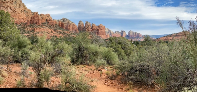
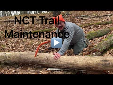
The North Country Trail (NCT) is a long-distance trail stretching from Vermont to North Dakota spanning 4,800 miles. Like all long-distance trails the NCT requires maintenance to keep the trail suitable for travel. That can include: clearing blow-downs, mowing, removing low-hanging branches, making and maintaning blazes, and more. The work is done by volunteers who work in association with local North Country Trail Association (NCTA) Chapters. Andy and I have been caring for our approximately 6.5-mile stretch of trail for more than a decade. You can learn more about the NCT and how you can get involved by visiting the NCTA website.

Play video Fall NCT Trail Work - Full Length
▶️ Play Fall NCT Trail Work - Full Length

We have a longer section of trail than most. We have close to a 4-hour drive from the Ann Arbor area. This is why we have a lengthy section we can tackle over a weekend thus making the drive worthwhile. You never know what will be necessary during any trail maintenance session. Sometimes we have encountered stretches of trail with massive blow-downs that require the chainsaw crew to come; sometimes, we seem to spend more time pruning trees and plants back; and once in a while we get through a lengthy section of trail and don’t have to do much of anything. The trail is always changing s there is likely always something that needs to be dealt with.

For this session we broke our work up into three pieces. On Friday we tackled what we expected to be the shortest stretch between Condon Lake and Highbanks Lake (animated map). On Saturday, after a leisurely breakfast, we left Condon Lake and headed sout towards Cleveland Drive and while that would prove to be the longest hike (see this animated map) it didn’t have too much to deal with one notable exception. On Sunday, after breaking camp and again having a lovely hot breakfast skillet, we tackled the remaining trail between 16 Mile Road and the Highbanks Lake side trail (animated map here). This modest section had the highest number of blowdowns to deal with and a seemingly endless supply of volunteer pine tree saplings growing right against the trail that needed to be pruned back.

Photos

Photo taken Nov 11, 2022 at 4:22 PM

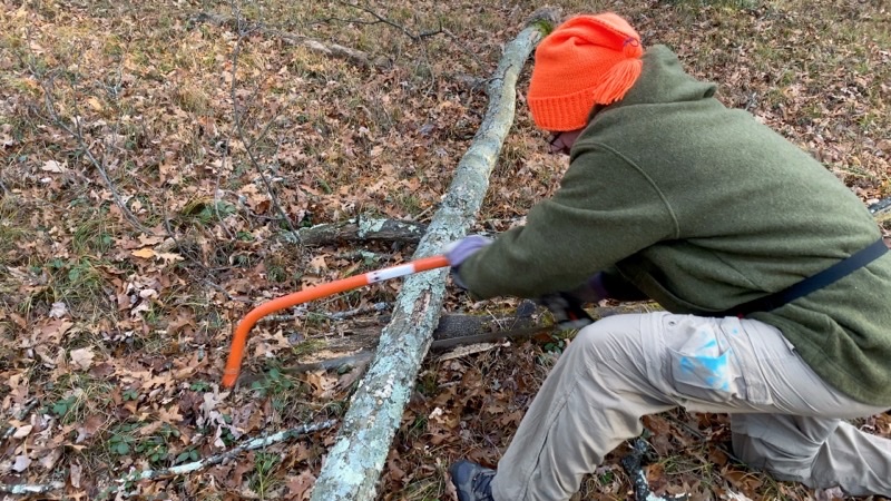
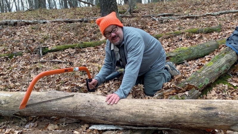
We try to deal with even fairly hefty trees that have fallen across the trail. Here Andy is working hard with a 36-inch bow saw.

—November 11, 2022 at 4:22 PM.

Photo taken Nov 11, 2022 at 5:36 PM

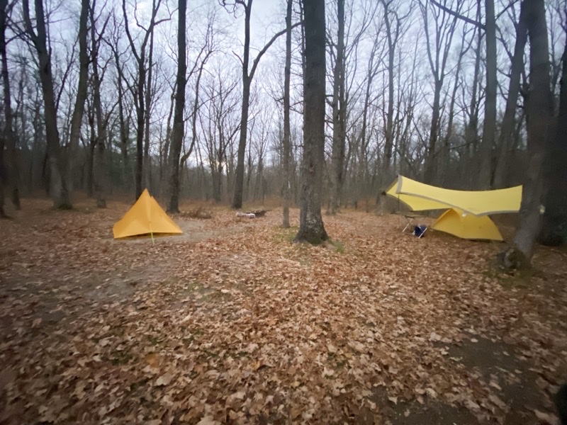
We were fortunate to find Condon Lake campground completely empty. Last time we were here we had several astonishingly loud and rude neighbors. This weekend we had the place to ourselves except for a few hours when a group of people came by to do some target shooting. On the left is my Mountain Laurel Designs Duomid. Andy has set up an MSR Wng above his Black Diamond Lightning. The joys of car camping.

—November 11, 2022 at 5:36 PM.

Photo taken Nov 12, 2022 at 11:57 AM

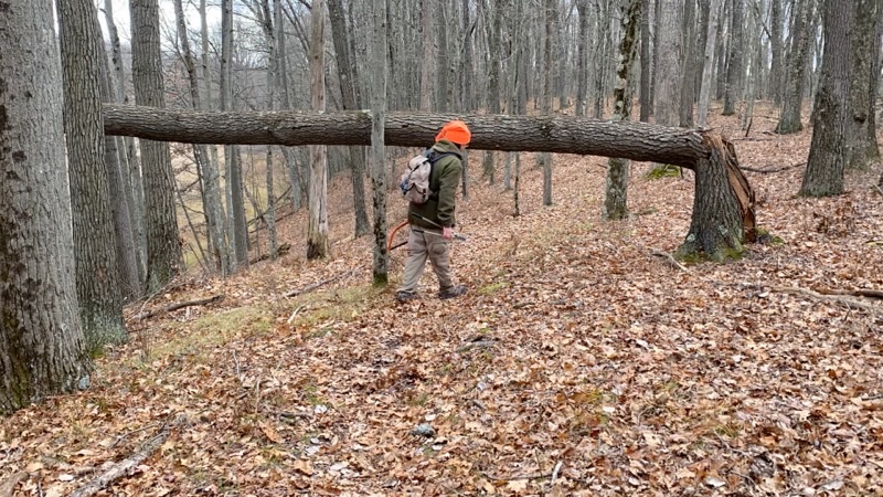
Some fallen trees are too wide for our bow saws to handle. But even if it had been a bit smaller I am pretty sure we would have left this tree for the chainsaw crew to contend with.

—November 12, 2022 at 11:57 AM.

Photo taken Nov 12, 2022 at 12:02 PM

This fallen tree required us both to work on it. Off to my right Andy is cutting through too. We are going to remove the section of tree from the trail. Between the two of us we got our cuts done in about 20 minutes. Andy was able to shift the log after we cut it loose.

—November 12, 2022 at 12:02 PM.

Photo taken Nov 12, 2022 at 12:16 PM

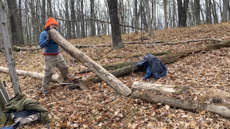
Muscle power. Andy is hoisting the log we just cut. He will manage to walk it off the trail.

—November 12, 2022 at 12:16 PM.

Photo taken Nov 12, 2022 at 9:26 PM

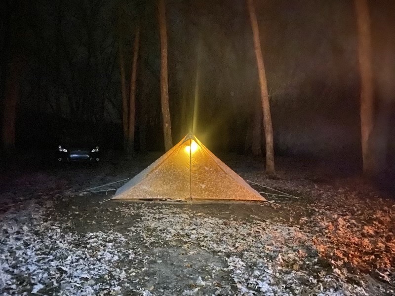
A dusting of snow has fallen since we came bafck from dinner at Barski’s and got our fire roaring. My MLD Duomid is glowing wonderfully from the light shed by a Goal Zero lantern. The air temperature is hoving around freezing but we are warm by the fire.

—November 12, 2022 at 9:26 PM.

Photo taken Nov 13, 2022 at 8:26 AM

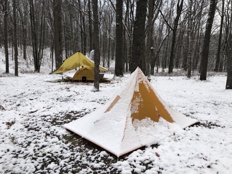
Good morning. It’s about 28 °F and this is the scene Andy and I have woken up too. Photo by Andrew Mytys

—November 13, 2022 at 8:26 AM.

Photo taken Nov 13, 2022 at 2:18 PM

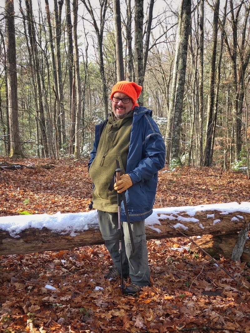
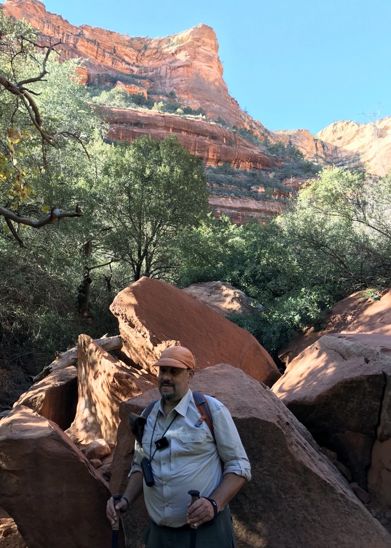
An occassional snowflake is falling as we deal with the half-dozen blowdown, most within a few hundred feet of each other, on our last day of trail Maintenance. But, the tree behind Ken is too big for us to tackle with our bow saws. Photo by Andrew Mytys

—November 13, 2022 at 2:18 PM.

Saturday, November 5, 2022

Sedona November 4 - Eagle’s Nest Loop and Montezuma’s Castle

Sedona November 4 - Eagle’s Nest Loop and Montezuma’s Castle

Eagle’s Nest Loop Trail in Red Rock State Park

This animated map will give you an idea of what the hike was like.

Today dawned clear and cold. The temperature dropped below freezing and that showed up as frost all over our rental car. We waited for the temperature to rise. As the sun rose the frost melted and around 10:00 it was edging past 40°F. We packed up the car for the short drive to Red Rock State Park to tackle the Eagle’s Nest Loop Trail. This loop is about 2.9 miles long (it used to be shorter when both Oak Creek bridge crossings were intact but a bridge washed out and that lengthened the hike by about 0.3 miles). The hike ascends from Oak Creek to the top of a mountain gaining about 210 feet which you then must descend. The bulk of the climbing is on well maintained switchbacks that most people will have no trouble with. We spent 2 hours 15 minutes enjoying the clear, bright, if a bit crisp, morning. We took about 15 minutes in breaks.

Photo taken Nov 4, 2022 at 10:34 AM

Oak Creek flows through Red Rocks State Park creating a riperian ecozone around the water. It’s incredibly dense with flora around the creek with cottonwoods dominating but numerous other trees and such abound.

—November 4, 2022 at 10:34 AM.

Photo taken Nov 4, 2022 at 10:44 AM

Just after passing by a sign informing us about a wildlife viewing bench Mom and Dad spotted this mule deer off in the distance. I was actually able to see it with my monocular though I didn’t see it as I took this photo. A nice treat.

—November 4, 2022 at 10:44 AM.

Photo taken Nov 4, 2022 at 10:47 AM

Mom standing in front of these red rock cliffs in Red Rocks State Park which opened to the public in 1991.

—November 4, 2022 at 10:47 AM.

Photo taken Nov 4, 2022 at 11:00 AM

Looking in a generally eastern direction from Eagle’s Nest in Red Rocks State Park. I believe Cathedral Rock along with (probably about 5 miles away) other great formations can be seen in this photo.

—November 4, 2022 at 11:00 AM.

Photo taken Nov 4, 2022 at 11:01 AM

Another view from Eagle’s Nest. To reach this point you climb several reasonably gentle switchbacks. At this point we have climbed about 120 feet from Oak Creek to this point. Much of that climb is in about 0.3 miles.

—November 4, 2022 at 11:01 AM.

Photo taken Nov 4, 2022 at 11:06 AM

After leaving Eagle’s Nest we gradually climbed to the top of the plateau. The trail is easy here and sports some fantastic vistas such as this one with Cathedral Rock in the distance.

—November 4, 2022 at 11:06 AM.

Photo taken Nov 4, 2022 at 11:36 AM

—November 4, 2022 at 11:36 AM.

Photo taken Nov 4, 2022 at 11:37 AM

Near the highpoint along the Eagle’s Nest Trail. The vistas all seem to be to the east of where we are hiking, but since that means you see massive and iconic rock formations like these that is fine with us on this crisp clear day.

—November 4, 2022 at 11:37 AM.

Photo taken Nov 4, 2022 at 12:11 PM

Ken descending the red sand switchbacks heading towards Oak Creek. Photo by Jonathan

—November 4, 2022 at 12:11 PM.

Photo taken Nov 4, 2022 at 12:36 PM

Looking across the prairie towards Oak Creek and, I believe, the mountain that we just walked across on the Eagle’s Nest Trail.

—November 4, 2022 at 12:36 PM.

Montezuma’s Castle National Monument

We weren’t ready for our day to come to an end. We drove about 40 minutes to Montezuma’s Castle National Monument. If you pay for a pass at this monument you are also covered for Tuzigoot National Monument. However, since we have Golden Age and Golden Access passes we did not have to pay any entrance fees. Montezuma’s Castle is, it seems to me, a poor name for this place. It gained that name when a European explorer found the place and thought he had discovered something of the Aztec civilization (if I read the sign right). There is nothing Aztec about the people who lived here 1,000 years ago (and perhaps as recently as 700 years) but it is the name that has stuck. Perhaps because we do not know what those people called themselves, but couldn’t something better be found for the name of their dwellings ? There are numerous dwellings built into the cliffs here. It’s a remarkable achievement. To be sure the room must have been dark but they would have been as warm and as cool as could be hoped for during the winter and summer. The valley, with Beaver Creek flowing through, would have doubtless provided many resources in this otherwise harsh land.

Photo taken Nov 4, 2022 at 2:18 PM

Cliffs dwellings at Montezuma’s Castle.

--November 4, 2022 at 2:18 PM.

Friday, November 4, 2022

Sedona November 3 - Tuzigoot National Monument

A fast-moving storm moved through the region. It brought substantially colder temperatures though at the elevation here in Sedona the precipitation was limited to rain and perhaps a bit of hail. Scattered showers throughout the day. It wasn’t weather to encourage hiking so we decided to visit Tuzigoot National Monument. Tuzigoot is, I believe, an Apache word that means “crooked waters” and I assume refers to the river that runs through the Verde Valley. There is probably much more to see at the national monument than the short 1/3-mile long paved trail that loops around the highpoint where several ancient pueblos (dwellings) stand. But we did not explore.

Photo taken Nov 3, 2022 at 10:22 AM

A view of the Verde Valley as seen from just below the pueblos at Tuzigood National Monumnet. The valley is well placed to serve as a conduit for people living at higher and lower elevations. While not visible here, the Verde River was bigger centuries ago,

—November 3, 2022 at 10:22 AM.

Photo taken Nov 3, 2022 at 10:26 AM

This is what is left of many of the rooms in the dwellings. We were able to enter into a still roofed room a bit later. It’s dark but clearly solidly built. However, it must also be rather cramped by our standards unless families were very small.

—November 3, 2022 at 10:26 AM.

Photo taken Nov 3, 2022 at 10:30 AM

The clouds are moving quickly. We hadn’t spent all that much time at the dwelling place when the sky suddently seemed to clear. Scattered rain showers drifted through the region all day long.

—November 3, 2022 at 10:30 AM.

Photo taken Nov 3, 2022 at 10:32 AM

With a touch of sunshine a faint rainbow developed. Had I been here alone I certainly would never have seen it. Thanks, Mom.

—November 3, 2022 at 10:32 AM.

Thursday, November 3, 2022

Sedona November 2 - Bell Rock and Courthouse Butte Loop

This animated map will give you an idea of what we did on this hike.

The morning started out with much greater cloud cover than we had seen since the first day. Over the course of the hike the clouds would slowly disperse.Temperatures rose from 54°F to 65°F. We were out and about for 3 hours 11 minutes and spent just over 25 minutes taking breaks. The Bell Rock and Courthouse Butte Loop is about 4.25 miles long and you will climb 270 feet and descend the same amount. The steepest part of the hike (going clockwise) ascends around the 2 mile mark. Within the Munds Mountain Wilderness the trail is a little more rugged but still on the easy side of moderate.

Photo taken Nov 2, 2022 at 9:23 AM

The process to create the rock formations we see today took millions of years. Millions of years ago sea levels rose and fell. The sea retreated and wind and river actions formed sand dunes which then turned into the variagated sandstone formations we see today. On the left you see Bell Rock and Courthouse Butte is on the right. The reddish layers are sandstone with iron particles that have oxidized. The white layers were created when salt was deposited over the ancient sand dunes. The cap of Bell Rock is limestone which was deposited when the sea was present.

—November 2, 2022 at 9:23 AM.

Photo taken Nov 2, 2022 at 9:23 AM

Courthouse Butte stnads about 0.5 miles away. The rock formation rises about 970 feet. It’s hard to tell but I think it is certainly a half-mile across (east to west) and somewhat less from north to south.

—November 2, 2022 at 9:23 AM.

Photo taken Nov 2, 2022 at 9:41 AM

Mom and Dad. The trail here is busy with hikers and bikers. It’s fairly flat for the first 1.75 miles or so. At this point we are following part of the Bell Rock Pathway. Bell Rock rises 479 feet from its base. Depending on where you are, it may look somewhat less bell-like. I think it looks a bit more like a hat with a pom-pom at this vantage point looking at the rock’s southern face.

—November 2, 2022 at 9:41 AM.

Photo taken Nov 2, 2022 at 10:00 AM

The day started out more cloudy but over time the cloud coverage has been diminishing. But the clouds still make for a stunning sky as we look at the northwestern face of Bell Rock.

—November 2, 2022 at 10:00 AM.

Photo taken Nov 2, 2022 at 10:05 AM

We have left Bell Rock behind and are beginning to navigate around Courthouse Butte. The trail is getting a bit more rugged with more short ascents and descents on sometimes rockier terrain.

—November 2, 2022 at 10:05 AM.

Photo taken Nov 2, 2022 at 10:14 AM

There is more to see besides Bell Rock and Courthouse Butte. This seems like a mountain range to me.I believe the leftmost rock formation is Gibraltar Rock. Courthouse Butte stands to the southeast of us.

—November 2, 2022 at 10:14 AM.

Photo taken Nov 2, 2022 at 10:22 AM

I wish I had caught this picture a few seconds earlier than I did. At that point the sun was creating a smaller but more pronounced spot upon the rock.

—November 2, 2022 at 10:22 AM.

Photo taken Nov 2, 2022 at 10:29 AM

Signs of progress. At this point the Courthouse Butte Loop trail does get a bit tougher to walk. I won’t call it hard but the footing is rockier.

—November 2, 2022 at 10:29 AM.

Photo taken Nov 2, 2022 at 10:31 AM

Looking at the northern face of COurthouse Butte.

—November 2, 2022 at 10:31 AM.

Photo taken Nov 2, 2022 at 10:40 AM

The trail feels more remote here. We have finally moved far enough from State Route 179 that the sounds of traffic have mostly faded away. Photo by Judy.

—November 2, 2022 at 10:40 AM.

Photo taken Nov 2, 2022 at 10:41 AM

You can see that the Courthouse Butte Loop Trail is a bit more rugged than the nearly flat trail near the parking lot. It is still a pretty well travelled trail. Photo by Jonathan

—November 2, 2022 at 10:41 AM.

Photo taken Nov 2, 2022 at 11:02 AM

More than rock formations, there is life here. We have seen some flowers, plenty of plants including trees (pinyon pine), and heard various birds and insects.

—November 2, 2022 at 11:02 AM.

Photo taken Nov 2, 2022 at 11:07 AM

The western face of this dome shaped rock that I cannot find a name for.

—November 2, 2022 at 11:07 AM.

Photo taken Nov 2, 2022 at 11:11 AM

The southeastern face of the hamburger bun shaped dome.

—November 2, 2022 at 11:11 AM.

Photo taken Nov 2, 2022 at 11:35 AM

It is time for lunch in the shadow of Courthouse Butte (northeastern face)

—November 2, 2022 at 11:35 AM.

Photo taken Nov 2, 2022 at 11:52 AM

In this little open space with Courthouse Butte to our northwest we found a few puddles which marked the only water we saw today. People were out and about hiking, biking, and I think meditating.

—November 2, 2022 at 11:52 AM.

Photo taken Nov 2, 2022 at 12:03 PM

We have left the Courthouse Butte Loop Trail and are travelling the far easier Big Park Loop Trail back towards the parking lot. Looking back to get a final view of Courthouse Butte.

—November 2, 2022 at 12:03 PM.

Photo taken Nov 2, 2022 at 12:19 PM

Glancing back at Bell Rock as we hike the final few tenths of a mile to the parking lot.

—November 2, 2022 at 12:19 PM.

Wednesday, November 2, 2022

Sedona, November 1: Fay Canyon Trail and the Chimney Rock Upper Loop Trail

We decided to do two shorter hikes today instead of one lengthier one. The weather was kind to us providing partly cloudy (or is that mostly sunny) skies throughout the day. When we started our day the temperature was about 54°F and it rose throughout the day to about 68°F. Another fine day to be outside.

Fay Canyon Trail

This animated map will give you a sense of what this hike is like.

Fay Canyon Trail is an easy trail. It is just over one mile long ending at a massive rockslide. The footing is generally along a hard sandy pathway but there are a few short stretches of rocky bits. Over the course of the trail you gradually ascend about 160 feet. Of course, when you retrace your steps you will descend 160 feet. It’s a fine trail to take people that do not like to hike because, as you will see, there are some remarkable red rocks even if none of them is a classic Sedona iconic formation per se.

Photo taken Nov 1, 2022 at 8:55 AM

Mom and Dad at the start of the Fay Canyon Trail. Fay Canyon Trail is just over 1 mile long ending at a massive rockslide. At this point the canyon is open feeling and the views of some of Sedona’s red rocks are expansive.

—November 1, 2022 at 8:55 AM.

Photo taken Nov 1, 2022 at 9:13 AM

Fay Canyon Trail passes through many shadier spots like this one but throughout the great rocks of the area are visible. Here Ken is in the foreground. The trail is generally sandy with a few short stretches of rocky bits. The trail ascends gradually as you go deeper into Fay Canyon.

—November 1, 2022 at 9:13 AM.

Photo taken Nov 1, 2022 at 9:35 AM

Ken is standing in front of the rockslide that marks the end of Fay Canyon Trail. Photo by Judy.

—November 1, 2022 at 9:35 AM.

Photo taken Nov 1, 2022 at 9:37 AM

Mom and Dad at the rockslide at the end of Fay Canyon Trail.

—November 1, 2022 at 9:37 AM.

Photo taken Nov 1, 2022 at 10:00 AM

Fay Canyon Arch isn’t the most stunning arch but it is yet another nice example of the various rock formations that make Sedona the special place it is.

—November 1, 2022 at 10:00 AM.

Chimney Rock Upper Loop Trail

This animated map will give you a sense of what this hike is like.

This hike makes use of a couple trails to form its loop. Combining Thunder Mountain and Chimney Rock Trails you walk about 1.8 miles and climb about 260 feet and descend the same amount. There are some overlooks along the way that are reportedly quite pretty but we did not explore them. If you hike the trail in the morning the guidebook suggests hiking counter-clockwise to keep the sun at your back. If you hike in the afternoon you go in the clockwise direction. However, if you prefer your steeper section to be full of steps going uphill you should tackle the loop in a counter-clockwise direction no matter what time it is.

Photo taken Nov 1, 2022 at 11:00 AM

Just the first grand rock formation we saw as we walked the Upper Chimney Rock Loop Trail. I’m not actually entirely sure that this is Chimney Rock but am not sure what else it could be. What is striking in this massive formation is the white rock embedded in the rock.

—November 1, 2022 at 11:00 AM.

Photo taken Nov 1, 2022 at 11:14 AM

The trail is beginning to climb more steeply as we continue curving around the now completely visible Chimney Rock.

—November 1, 2022 at 11:14 AM.

Photo taken Nov 1, 2022 at 11:15 AM

The pillars in the distance remind me a bit of Cathedral Rock though they certainly are not that iconic formation. Given enough time the forces of nature can sculpt some fascinating shapes in the soft red sandstone of Sedona.

—November 1, 2022 at 11:15 AM.

Photo taken Nov 1, 2022 at 11:33 AM

Taking photos is important. Here is a case study of Ken and Jonathan doing just that. Photo by Judy.

—November 1, 2022 at 11:33 AM.

Photo taken Nov 1, 2022 at 11:33 AM

The trail steadily climbs up numerous stone stpes quickly ascending the bulk of the 250 or so feet in less than 0.5 miles.

—November 1, 2022 at 11:33 AM.

Photo taken Nov 1, 2022 at 11:33 AM

Looking back down those numerous steps as Mom snaps a photo. If you hike the Upper Chimney Rock Loop counter-clockwise you’ll be ascending quite a lot of these steps.

—November 1, 2022 at 11:33 AM.

Photo taken Nov 1, 2022 at 11:36 AM

Respite from the steps. THe gentler stretch won’t last long but it’s nice to have a break no matter how short.

—November 1, 2022 at 11:36 AM.

Photo taken Nov 1, 2022 at 11:47 AM

Just beyond the highpoint we found a rock bench to settle down upon for our brief lunch. This is the view we were treated to as we ate.

—November 1, 2022 at 11:47 AM.

Photo taken Nov 1, 2022 at 12:08 PM

The descent of Upper Rock Chimney Loop is far gentler than the ascent. The trail circles farther around from Chimney Rock and I suppose that’s why it is generally a shallow grade relying far less on stone steps.

—November 1, 2022 at 12:08 PM.

Photo taken Nov 1, 2022 at 12:31 PM

This is about the last view of the chimney of Chimney Rock.

—November 1, 2022 at 12:31 PM.