Wind. I stepped out of my modern spacious room into the hotel hallway that was acting like a superb breezeway. Dad would exclaim that it was “freezing outside” though I personally think he exaggerates for effect here. The temperature is probably no lower than 60 °F (15 °C). Breakfast starts promptly at 07:30. The hotel has a rope blocking entry until a staff person comes at 07:30 on the dot to remove it and let people in. You’ll find a buffet with an assortment of food that will certainly meet the caloric needs of the body even if it doesn’t excite the taste buds. You aren’t staying here for a quality foodie experience.
Today we would take our nearly full bus into the center of the island. Roque Nublo is about 26 miles from here and that requires about 80 minutes to drive the twisting two-lane mountain roads. Vehicles, certainly larger ones like our bus, have to take care making some turns. It is not a fast drive. With a stop along the way to use bathrooms (and I should have taken a photo of the pony/donkey that ambled into the sidewalk that led to the bathrooms and blocked our path and didn’t seem to care) we reached the drop off point at about 10:35. The sky was clear and the temperature had warmed up nicely even though we were at about 5,200 feet above sea level. We elected to do the easier walk. The harder walk added an extra two miles that, if I understand things right, we would skip by driving to a second starting point.
The path to Roque Nublo sits on basalt and ash. It is a stone path that is quite wide: easily 6 feet oftentimes. The stone underfoot is stable and rough providing good purchase for shoes with grippy soles. If it were wet it would likely be awful. Over the about the next 0.9 miles we would ascend 500 feet. Sometimes that climb would be steep. No section was particularly long but you would have to step from rock to rock. For people with good balance this isn’t likely too big a concern but for me it is slower going especially on the way back down.
It’s a very popular trail. Easily scores of people from the very young to elderly were out on it. That would force pauses in our travel as one group of people would have to yield to another (the ascending one if rules of the road are being observered). Up and up we went. We passed through a stand of trees as views of the caldera spread out before us. In time we could look ahead and up and see Roque Nublo rising above the summit in its monolithic glory.
We lost a few people along the ascent up. They turned back and waited for us at the bus. For some the climb was steeper than they wanted to deal with; for one the issue was the yawning expanse of the caldera dropping off on one side. Mom and Dad decided to not forge ahead up the last couple of short ascents to the mesa where Roque Nublo and The Frog sit. I pushed on with the group the last 0.1 or so miles up some steeper, have to step-up (down) rocks, that took me the better part of 10 minutes to deal with. But Roque Nublo beckoned. The monolith rises 80 meters from the base though it doesn’t look like it is that tall. Of course, you are easily 250 meters from its base when you enter the mesa. We spread out and marveled at the rock formations and then drifted to the western edge of the mesa to gaze across a caldera and far out into the hazy distance where Mount Teide rose up claiming the honor of Spain’s highest point rising above the island of Tenerife. From the eastern edge Caldera de Tejeda (I think) falls away. From that vantage point The Frog looked more frog-like (toad-like). Though if you don’t see the bulbous protrusions you could think The Frog is a sitting dog in maybe the bulldog family with the squished face.
Going back down seemed to take longer than climbing up. It probably didn’t but it is, for me, more work. Sure we had to pause now and then to let an ascending group go by and the number of people on the path seemed to have increased but I don’t think that lengthened the time of our descent too much. We found Mom and Dad at the base of the last descent where Roque Nublo was easily visible. They’d grown tired of waiting for us. We had after all lingered at a couple places to get a short talk from our guide each time.
Within 40 minutes we had clamored down the steep-step-down-rocky bits plus the more common steady descent dropping back down 500 feet over the 0.9 miles back to the bus. Time enough to buy a Fanta at the mobile food stand and pile in for the short drive to the drop-off point for the second part of the walking today.
We had something like 4 miles to go with 600 feet of ascent and 1,100 feet of descent. Of course, those are the stats in the booklet and the booklet doesn’t seem to hold precisely to the reality on the ground (assuming my GPS tracks are accurate and I’ve no reason to believe they are not). We struck out on a wide dirt path, almost a road, that wound through a forest of various trees that were growing nowhere near as densely as the laurel forest we explored the previous day. I am sure some of the tree were pine trees or at least evergreen as we did trod upon some nice needle-covered ground. It was a fine afternoon as we passed by a “camp” for groups to rent. I think it might be similar to a place a group like the Scouts might use for overnight type activities that engage people in outside events including sports. There were basketball courts, an empty swimming pool, and many buildings. But that was just a place we would pass on our way to the rim (they say balcony) trail that winds around Caldera de Tejeda. We would spend the bulk of the walk working our way counter-clockwise along this gentle dirt path that is well maintained. It’s easy walking. The views across the caldera are spectacular. Now and then you can look out to the west and see Tenerife. I think the rock formation we sat across from at lunch may have been the one Belinda, our guide, called The Monk which we saw climbing to Roque Nublo.
Around we went, generally descending, passing through stands of trees now and then. We eventually came to a road but we were going to take a path that would contour around, up and down, several hills that the road passed by. Once again the footing was generally excellent with just an occasional bit of less good trail. The ascents were a bit steeper but not really steep especially compared to the Roque Nublo path. Descents were similar in quality though they were a bit longer. The last descent into Cruz de Tejeda was probably about 0.5 miles long but not really a challenge. We arrived in the village where the group doing the harder walk was waiting at about 15:30. That gave us enough time to visit bathrooms and have a drink. We had walked 3.75 miles over the last 2 hours and 45 minutes (including breaks). This time the booklet overstated the numbers. We enjoyed our walk around the caldera and if it wasn’t for the well over an hour drive each way I would give both walks a big thumbs up. If you do them just know you will have a lot of time on a bus.
Stats Rock Nublo: 1.8 miles out-and-back (if you go to the base it’s probably 2 miles). 500 feet of ascent and 500 feet of descent. Har d rock surface with sections of rough rock and uneven large step-up/down that will slow you down (well slowed me down). If the rock is wet it would be awful.
Caldera de Tejeda: 3.75 miles with 400 feet of ascent and 820 feet of descent. The bulk of the descent happens after you leave the rim trail. Ascents are mostly on the hills after the rim trail though there is some at the start. Dirt trails with excellent footing. Spectacular views.
Photos
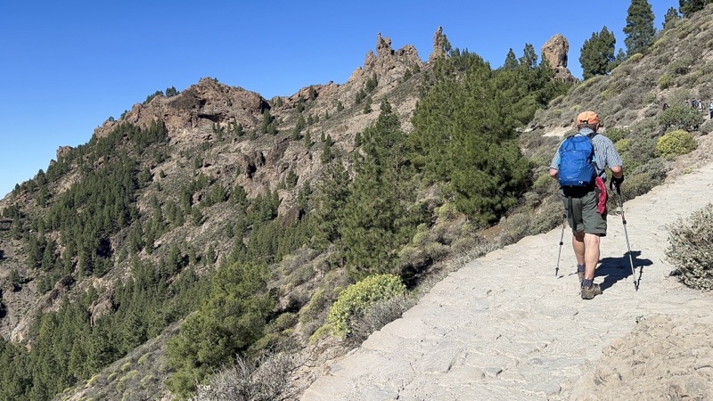
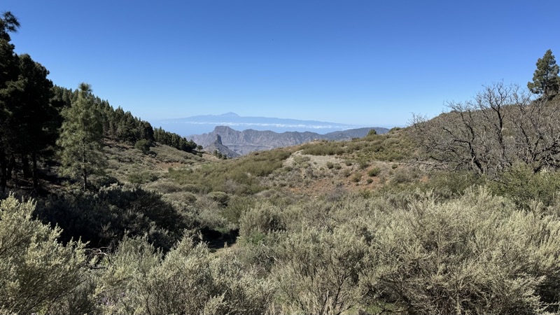
Near the start of the about 0.9 miles hike up a trail built atop the basalt mountainside that leads to Roque Nublo.
--February 21, 2024 at 10:49 AM.
Maps are centered on the photo: Google map, Apple map, OpenTopoMap map
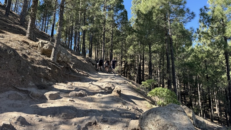
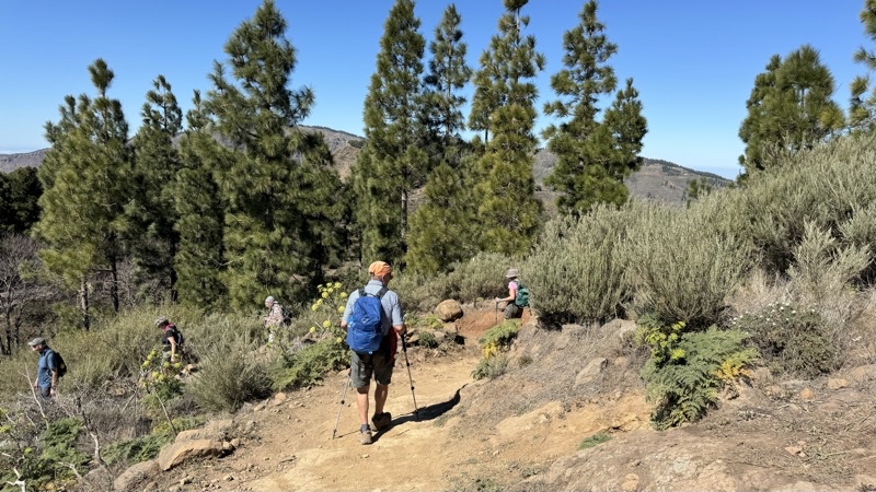
The trail remains quite wide and has occassional steeper bits but for the most part is a steady climb up rock that is, at least when dry, providing pretty good footing. There have been spots where you have to step up more than I like. This little stretch of forest seems a bit odd in that it is here at all.
--February 21, 2024 at 11:07 AM.
Maps are centered on the photo: Google map, Apple map, OpenTopoMap map
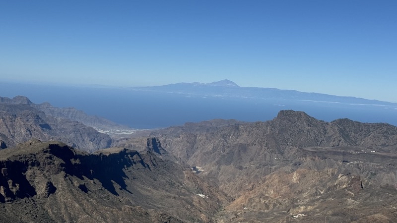
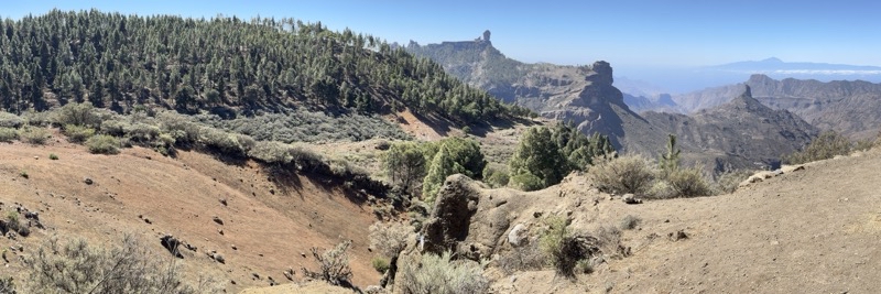
In the hazy distance you can see the highest peak in Spain rising up. Mount Teide is on the island of Tenerife which is about 35 miles west of me.
--February 21, 2024 at 11:39 AM.
Maps are centered on the photo: Google map, Apple map, OpenTopoMap map
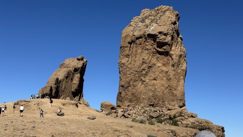
Roque Nublo is on the right perhaps 500 feet away from where I am standing. It rises 80 meters though it doesn’t look like it. I don’t know if the rock on the left has an official name but Belinda says the locals refer to it as The Frog and I suppose I can see that. The last couple ascents while not long are a bit more challenging since the rocks are uneven and there are many larger steps to deal with. Normal people will still not have too much trouble. I think it took me about 7 minutes to make the last climb (and descent) of perhaps 300 trail feet that rose 40 feet.
--February 21, 2024 at 11:46 AM.
Maps are centered on the photo: Google map, Apple map, OpenTopoMap map
It is hard to get a sense from the photo of how deep and wide this caldera is. We are walking counter-clockwise around a portion of the rim of Caldera de Tejeda.
--February 21, 2024 at 1:22 PM.
Maps are centered on the photo: Google map, Apple map, OpenTopoMap map
We had a nice lunch break at this spot. If we were really pushed for time I bet we could have left in 20 minutes instead of the half-hour we got to spend here.
--February 21, 2024 at 1:51 PM.
Maps are centered on the photo: Google map, Apple map, OpenTopoMap map
We have been descending down towards the road. I think this may be the primary road that leads to our endpoint at Cruz de Tejeda.
--February 21, 2024 at 2:20 PM.
Maps are centered on the photo: Google map, Apple map, OpenTopoMap map
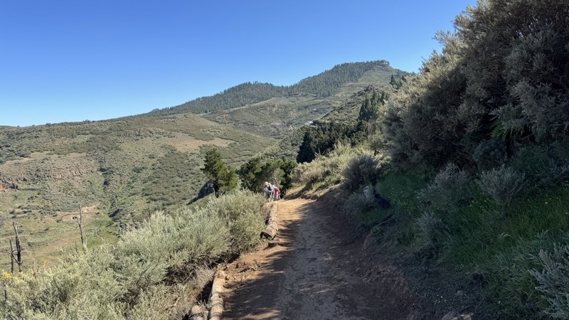
Looking back towards Mom and Dad as they come into view along this path that is contouring around several hills above a busy road. We have a couple short ascents on good paths and then a gentle half-mile-long descent into Cruz de Tejeda.
--February 21, 2024 at 2:58 PM.
Maps are centered on the photo: Google map, Apple map, OpenTopoMap map
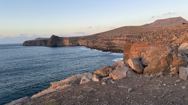
In just a few miniutes the sun will set and the colors will have faded from the cliffs that plunge down into the Atlatic Ocean.
--February 21, 2024 at 6:48 PM.
Maps are centered on the photo: Google map, Apple map, OpenTopoMap map
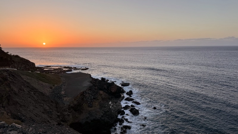
Down Sol goes. Less than 5 minutes but the colors have faded from the rocks leaving just the sky around the Sun colorful shades of orange and dusky blue.
--February 21, 2024 at 6:51 PM.
Maps are centered on the photo: Google map, Apple map, OpenTopoMap map
No comments:
Post a Comment