Thursday, May 22, 2014


Sunday, May 18, 2014
Thursday, May 15, 2014
Wednesday, May 7, 2014
Rhode Island beach walk
May 7, 2014 9:24 am - a very nice beach. Many of the houses suffered damage from hurticane Sandy and work continues to repair them.
Name: Track 094
Date: May 7, 2014 9:24 am
Map:
(valid until Nov 3, 2014) View on map
Distance: 2.20 miles
Elapsed Time: 53:10.6
Avg Speed: 2.5 mph
Max Speed: 3.9 mph
Avg Pace: 24' 13" per mile
Min Altitude: 2 ft
Max Altitude: 81 ft
Start Time: 2014-05-07T13:24:03Z
Start Location:
Latitude: 41.341525º N
Longitude: 71.694768º W
End Location:
Latitude: 41.341716º N
Longitude: 71.694725º W
Sunday, May 4, 2014
#35: Manistee River Trail March Winter Weekend 2014

It has been a while since I've managed to go on any winter backpacking trips. In fact, it has been several years since I've actually done more than day hiking in the winter even if some of those trips were based out of rustic cabins in places like Wilderness State Park by Mackinaw City or the cabins in the Waterloo-Pinckney Recreation Area. So this two-night weekend spent hiking a portion of the Manistee River Trail with friends was a real treat. Joined by experienced, in some cases (maybe all), winter backpackers Doug, Ewa, and Paul (and Paul's dog Capone) we planned a fairly modest couple days of hiking in and then back out on the Manistee River Trail. Their was a time when I had hiked the entire loop which includes the North Country Trail on the other side of the Manistee River covering about 21 miles over a weekend in snowshoes but this trip would be nowhere nearly that ambitious. Our plan was to drive to Red Bridge Friday night and either camp right there or somewhere nearby, hike however far on Saturday to some point along the trail, and return Sunday for the drive back to our respective homes.
We would meet at Barski Bar in Baldwin and after dinner drive to Red Bridge to start our hiking weekend. I suspect that their aren't that many places to eat in Baldwin, Michigan. Barski's though has some truly wonderful food. I imagine the burger I had that was topped with an egg plus the more usual burger toppings would make a cardiologist cringee but boy was it tasty. The meals everyone else had create similar amounts of gastronomic pleasure and none of us worried much about the calories. After all, we were about to go on a winter hike. It would be well past sunset when we managed to park our two cars in the unplowed snowy parking lot at Red Bridge. We hoisted our packs, heavy with winter gear, grabbed our snowshoes and began the hike which starts with a quarter-mile tromp down North Coates Highway to where the MRT trailhead is. Once there we did a bit more gear re-arranging , stepped into our snowshoes, and began the slow process of hiking along the narrow snowy Manistee River Trail.
********** ********** **********
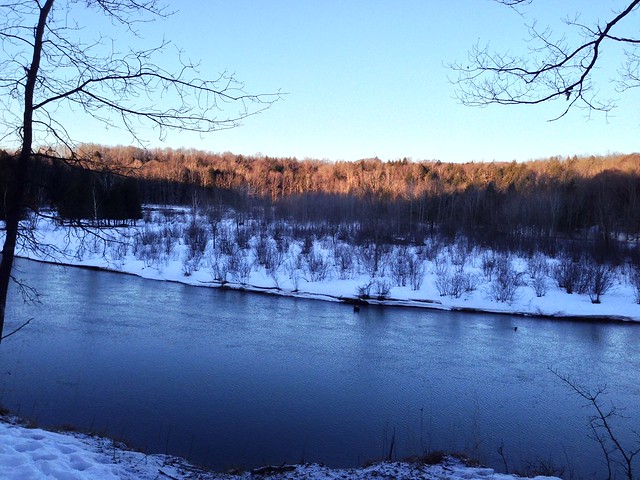
We were in no rush to leave camp Saturday morning. While we all started to stir not long after sunrise we did not actually leave camp until about 11:00. We were only going to hike about 3 miles so leaving so late was hardly a hardship. When we left to hike the rolling hills it was overcast but nice enough. We made our way methodically along the trail enjoying the frequent views of the river as we crunched loudly through the snow. When we reached our planned, well the site Paul figured would be good mostly because it has such fine river views, around 14:00 (perhaps a bit earlier than that) we settled in for a fine lazy afternoon. The sun was out and that made setting up camp a much nicer though perhaps not really all that much quicker of a task. Of course, it was far too early to be done with our day so after dawdling about camp for a while we decided to hike to Slagle Creek. What a wonderful hike that turned out to be. Sure hiking down in and then out of a ravine along a slick hillside was a tiny bit of a chore but only a small annoyance. The sun had conquered the clouds that had been out earlier and it was a fine day to be out enjoying the trail. Settling down later to soak up some of that sun along the southwest facing ridge by our camp was also a real treat.
********** ********** **********
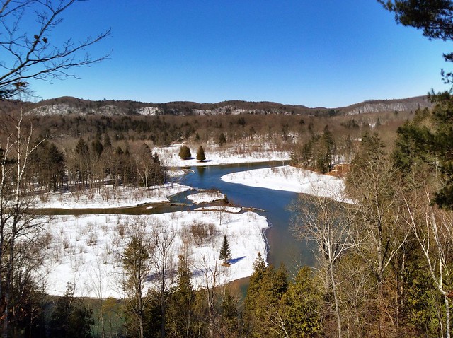
The hike back to the cars was as enjoyable as the hike out. To be sure the day was actually somewhat colder but that hardly matters when you're tromping through snow that if you break through will rise well past your calf. We did break camp a bit more quickly but we still weren't in anything like a real hurry. We had ample time to hike out and some of us were lucky enough to spy various wildlife along the way including a couple bald eagles. We paused a few times for enjoyable breaks, usually in places at least a little out of the wind though still with views of the river down below. I think the biggest surprise though of our return hike came near its end. On the way out, seemingly farther along than it really was we had to squeeze by a juniper bush that was pushing well into the trail. On our left the trail vanished into a drop-off that seemed to drop easily 30 feet into blackness that likely concealed a lot of muck. Getting past that bush was something of a trial. When we came to it in the glare of a high sun it was far easier to edge past it and the drop off turned out to be at most 8 feet and nowhere near as imposing let alone dangerous. Hiking at night changes your perspective.
We reached our cars a little after 14:00. Naturally we had to have a post-hike meal and so a return visit to Barski Bar was called for. I must say the rueben I had was even tastier than the burger of Friday night. Everyone else agreed their meals were equally good. After that fine meal it was time for Ewa and I to head back towards Ann Arbor while Paul and Doug returned to Grand Rapids. It had been a very good weekend indeed.
Check out this episode!
MRT Winter Trip
Google album (19 photos): Google album
Flickr album (15 photos): Flickr album
Monday, April 28, 2014
#34: North Country Trail Spring Maintenance 2014

On the weekend of April 11, 2014 Andy, Elwira, John and I went out to do our spring trail maintenance. Our section of North Country Trail runs from 13 Mile Road to 16 Mile Road (Newago County, Michigan) and includes the side trail to Highbank Lake Campground. All told this is about 6.4 miles of trail that passes by several lakes rising and falling through many gentle short climbs. This weekend will be remembered for the great thunderstorm that ripped through the area Saturday night and Sunday morning. Besides the hail and very heavy flood causing rains the storm brought gale force winds that likely hit speeds around 60MPH and brought down numerous trees. Sadly I suspect the section of trail we had worked on Saturday likely has new trees down that we couldn't get back too. We certainly found downed trees that had not been there on the Highbank Lake campground side trail Sunday afternoon.
Since we have a nearly four-hour drive to get to our section campsite located just south of Cedar Creek on FR 5311 not to mention the time we spend driving to places like 13 Mile Road and elsewhere we maintain a somewhat lengthier section than many to make all that travel time worthwhile - it just makes sense. Usually we have just one car so we have to do out-and-back hiking. While that does mean we can be certain our blazes are in great shape in both directions it does double the amount of hiking with our tools. Consequently we typically do our section in two pieces: 13 Mile Road to Highbank Lake campground the first day and 16 Miles to Highbank Lake the second day. Of course, before we can start working on the trail we must drive to the campsite and since we rarely seem to leave the Ann Arbor area before 6:00PM even when things are going smoothly we don't reach camp until rather late at night. This weekend would be no exception. It would, in fact, have a later start for several reasons all of which were outside our control and perhaps can be blamed for some troubles later in the weekend (well, OK that's likely a stretch).
******************************

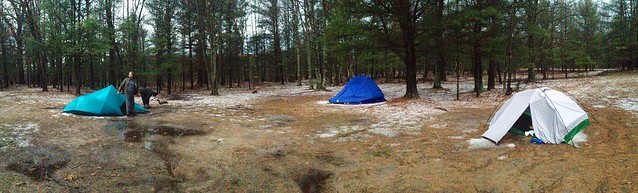
Even though we expected it to rain Saturday afternoon we didn't rush to get up and moving. After all, no one had gone to sleep before 1:00AM. But by mid-morning we were walking along the trail looking for things that needed to be dealt with. Surprisingly it turned out that we wouldn't have too much hard work to do. Plenty of small brush and a handful of blowdowns constituted the bulk of the work. A little bit of touch-up work on trail blazes, which is how Willow acquired that lovely blue tail, was done too. All in all as we passed by occasional patches of lingering snow as well as lakes that still had some ice floes bobbing about it was pretty easy work. The weather was holding off but we knew that couldn't last so after finishing off our late lunch at Highbank Lake Campground as a sporadic drizzle came down we put on our ponchos and headed back out. We planned to take a short cut which would use the forest service roads and a little cross-country hiking. I'm not sure how much of a short-cut it really ended up being but it certainly wasn't short enough. The storms we worried about started to pound us well before we reached the car. We had some confusion about where we were and the best way to go that may have slowed us up some but even had things gone perfectly I doubt we would've rreched the car before the downpour began. We poured our wet bodies into the car and drove into town for dinner rain falling hard all the way. One local, maybe he was a bit drunk, enthused loudly to the bar that the, "sky was falling." Certainly plenty of rain was and it would stop only briefly throughout the course of the next dozen or so hours. We returned to camp around 6:00PM and scurried into our respective shelters hoping the storm wouldn't last long. The rain stopped and the hail began. That was only the beginning of the extremely lousy, and potentially quite dangerous, weather we would be treated to all night long.
******************************
You can only stay in your shelter so long. That length of time diminishes when you feel you aren't sleeping well. So while John and Andy snored on I was moving about not long after sunrise. Elwira and Willow joined me soon after. The storms had finally abated and we quickly learned that the damage left behind was extensive. Trees had been brought down all over the place; Cedar Creek had flooded; drainage ditches on the forest service road were flooded. I've no doubt that trees are down and blocking the trail we had walked Saturday. Talk about bad timing. We found extensive blowdowns on the section of trail between 16 Mile road and Highbank Lake too as well as bonus blowdowns on the campground side trail.
As you can see doing trail maintenance can have its ups and downs. While you likely won't experience severe weather like we encountered during our weekend all that often it certainly can add a bit of spice to a weekend's worth of work. Even if you do not have a long distance trail like the North Country Trail near you chances are you have some trails near by that can use your help. If you do have a stretch of NCT nearby and want to learn more you can start by visiting the official webiste at northcountrytrail.org.
A Note about the audio: I am experimenting with a new external microphone for the iPhone. It's a Zoom IQ5 stereo microphone and the results are proving interesting. I don't quite understand why one channel is picking up my voice so much more robustly than the other but that seems to be happening. Perhaps I just need to learn the ins and outs of the microphone. It certainly has better fidelity than the little iRig Miccast I used before.
Photos can be found in the following places. The albums have the same pictures but present them differently: Flickr album, Google album
Check out this episode!
Subscribe to:
Posts (Atom)