Showing posts with label winter. Show all posts

Sunday, February 1, 2015

Alley of the Glaciers

Alley of the Glaciers Camp.jpgAlley of the Glaciers Camp

We arrived at our camp a little before 16:30. We had paddled about two thirds of our planned route in less than four hours. Our campsite has several gullies running through it. It did not occur to me what these might be but I think Larry must be right that they represent stream beds. They're a source of annoyance for me though as the banks are high enough to make a single step up or down impossible.

Several thousand years ago glaciers swept down across Michigan. I am not sure if they created the Manistee River but and all the associated rollings valleys but they certainly had a hand in shaping the land. Today the glaciers are gone and all we see in the winter is snow clad land along the curving course of the river. On the weekend of January 24-25, 2015 I joined 9 other adventurers to kayak approximately 17 miles of the Manistee River between Tippy Dam and Rainbow Bend. Our plan we to paddle about two-thirds of the distance on Saturday and the remaining third Sunday. We would overnight camp on the river. What follows are my thoughts written (and then edited later) during the trip. I hope you enjoy what you see.

Sitting on a couch In Lansing, MI - January 24, 2015

It never seems to fail: the night before a trip begins I sleep poorly. It's true that I couldn't sleep much even if I wanted to since we will be leaving so early but I have been laying on this couch for what seems a long time and not falling asleep even though I am tired. Maybe I can blame the couch but it is probably better to blame pre-trip jitters. After all, Mike C. , Mike J. and I spent some time earlier discussing things that could, though you fervently hope won't, go wrong during a winter kayaking trip. I am sure Mike J. is feeling jitters since he is the trip leader (OK, he has help from Larri but this is really his baby). I hope I can drop off soon because I want to feel ready for the real adventure later today.
Tippy Dam.jpgTippy Dam

It is overcast and nippy at Tippy Dam on the Manistee River. The temperature likely never rose much above the mid-upper 30s °F. It is obviously not too cold to keep fisherman from wading into the chilly water in their quest to catch steelheads. Our group arrived more or less at the same time and by 11:00 we had all our kayaks packed and ready to go. Man of the group then piled into cars to drive down to Rainbow Bend and thus set up the car shuttle. This would take well over an hour so our group of intrepid adventurers would not put paddle to water until about 12:30.
Snowy Bluffs.jpgSnowy Bluffs

We often would pass by bluffs like this. Now and then we thought we might have spotted the trails of river otters sliding down the snow into the river.

On the Mainstee River at camp (44.263781°N, 86.084637°W) - January 24, 2015

Fire!.jpgFire

Let there be fire. As soon as shelters were set up people including Aaron (shown here) were out and about gathering wood from mere twigs to modest logs for our necessary campfire. It sure would cast a wonderful warmth and glow for the several hours we all would cluster about it sharing stories, making up tales, chatting amiably about whatever came to mind. When Chuck "Pathfinder" Hayden made a surprise visit having hiked in from the road which lies a good mile or so away the amiability may have grown more pronounced still. The light freezing rain that turned to light snow didn't dampen our sprits one bit.
I wonder if any of our group, at least the contingent of me, Mike C., and Mike J. slept well. Goodness knows some of us had a long way to come to get to even the starting point at Tippy Dam. Getting to Tippy Dam wasn't that bad and everyone seemed to arrive by 10:00. But arriving at the starting point and setting out on the river are two different things. We had to spend a good hour unloading the kayaks from vehicles and then packing them up. That is always a chore. Shove, push, squeeze those drybags filled with sometimes bulky gear through the narrow deck hatches into the confined spaces of the kayak. Struggle to get the hatch covers on, one side is snugged down and while you work on the other it pops up again, secure everything in place. If you're lucky and careful you haven't forgotten to squeeze something important in. Time passes and even though it is a bit above freezing you are beginning to get cold. In the end the boats are packed but you still can't get in and start paddling because cars have to be driven to the take-out point which is well over a half hour away. The bulk of the group piled into cars to set up the shuttle leaving a few of us behind to chat, try and stay warm, and wait. At least we had good company including the couple of fellows standing knee-deep in the cold Manistee River fishing for steelhead. By 12:30 everything was in place and we were shoving off from the boat ramp and beginning our paddle down river. This is a swift flowing stretch of river especially once you get beyond the wider pond-like area just below the dam. You are quickly greeted by numerous bends including big oxbow bends that send you past high banks shrouded in snow and topped with trees both bare and evergreen. Except for the sound of conversation and the slap of paddles against the water it is pretty quiet on the river. Now and then a rifle caused by water surging past a rock or log makes a sound. People spotted plenty of activity: eagles, loons, turkeys, pileated woodpeckers, some other small birds, beaver - but they were all pretty quiet. I wish I had seen them. Instead I paid attention to where I was paddling and who I was following. I didn't want to run into anything if I could help it. Turned out I couldn't. Just beyond High Bridge I brushed through some branches that were farther out than I'd though and I took some foliage away with me. No harm done. It's possible to chat while paddling. Groups of two or three kayaks seemed to form and dissolve all the time. Even now, in my toasty warm sleeping bag, I can't tell you what we talked about. But it was pleasant conversation and the time went by quickly. We were moving quickly at any rate passing by banks sometimes low and approachable and quite often steep and inaccessible. Even with our break at the boat ramp by High Bridge we reached this campsite in slightly less than 4 hours. Our pine tree (white I think) forested campsite is cris-crossed by gullies. Until someone, Larri perhaps, suggested it I had no notion what they were but I think the idea that they are stream-beds makes sense. In the winter they're kayak storage spots and irritations for those of us with shorter legs. Other than that this is a fine campsite with easy access to the river and a perfect spot for our campfire which we kept alive for several hours before all heading to our tarps, tents, or hammocks for the long night. It is nice to have a campfire. It's very nice when someone else builds it. I am just not up for that. It takes too long to gather up wood of the proper sizes to birth the fire into something worthwhile. But we have plenty of people who dearly love a fire and they got one going in short order. No shortage of dead wood. Soon most of us were having dinner by the fire and then settled in around the comforting light and warmth sharing stories and relaxing, if that is the word for it when the temperature is steadily dropping below freezing and a bit of freezing rain turning to a modest flurry of snow, as time creeps on by. Pathfinder, aka Chuck Hayden, made an appearance. That was a shock to us all. He had parked on a nearby road, probably a mile and a half away, and bushwhacked in to our site. As I glance at the map there may be a trail nearby but I am not sure (can anyone confirm this?). He sure can liven any event up. But he wasn't staying so so even our desire to stay warm by the flames ebbed and around 21:00 - surprisingly late - everyone had dispersed to his or her shelter. I am comfortably warm on my new sleeping pad and I hope I can fall asleep and stay that way for the next several hours: sunrise is at 08:00 or so.
Good Morning, Sunshine.jpgGood Morning Sunshine

During the night the temperature plummeted down to around 10°F. If you were up and had the eyes for it you could see stars twinkling. The sun is rising on a chilly morning. Fortunately our campsite is reasonably protected from the wind so morning chores aren't too areas once you get moving and warmed up.
Larry on the River.jpgLarry on the River

Larry is perhaps our most colorful, certainly brightest, paddler passing by one of the many snowy bluffs.

Sitting on the couch in Lansing - January 25, 2015

The trip is done; the adventurous portion of it is done since I still have to take the bus back to Ann Arbor tomorrow morning. What a difference a day can make. Sunday dawned partly cloudy and promised to clear throughout the day. It was also considerably colder and windier. I doubt the temperature broke 20F and the low during the night may have nudge 10. But sunshine can make you feel warmer even if, to some degree at least, it is all in your head. Certainly when we gathered again around a campfire we were all warmer and you warm up remarkably fast trying to work frozen tent stakes out of the ground but it really wasn't too bad once we got moving and got some food into our bodies. No doubt the trees helped block the wind which certainly cut through us while upon the river. A very fine morning of lazy packing and sometimes a bit of fun. After all, you aren't in a hurry or concerned with the remaining third of paddling if you take time out to build a snowman. But you can only dawdle so long and again around 12:30 everyone was in their kayaks and on the river. The skies had cleared up completely and the wind started to chew into us. I am glad I had my rain jacket to help act as a windbreaker and I reckon the PFD added some protection too but we all felt the bite of the wind on exposed skin. I wonder if the big drop in temperature and rise in the wind kept fishermen away because today I think we only saw a couple fishing from small motorboats marveling that people would choose to kayak at this time of year. Personally, I think today was a great day to be out even though parts of me were quite chilled. Colors really popped and though we spotted far less wildlife it felt good to be outside. I think everyone felt quite alive even those that may have been wiped out by the kayaking. Those last couple of hours, covering the last third of the 17.5 miles of paddling, seemed to go by quite quickly and I am sure everyone enjoyed the time immensely. That enjoyment was marred by the wretched wind and cold that ripped through us as we unloaded, almost as much of a chore as loading, the boats and put them on their various cars.
Rainbow Bend.jpgRainbow Bend

We have arrived at Rainbow Bend and Mike, aka Seadod, is one of the last to disembark. Of course, we still had to unload our kayaks and then put them up on the various cars before we could depart. That seemed to take an eternity. The wind had become fiercer and that made everyone feel far colder than we had been all day.
Once we got back to Tippy Dam and sorted everyone out it was time to head off home. We had a nice enough bar dinner on the way and I think everyone enjoyed how this short adventure came to a good conclusion. I know I enjoyed it and I am sure I learned a few things along the way about myself, my gear, and other people. All 17 photos can been seen in this Flickr Album.

Thursday, January 3, 2013

A Week in Tucson, Arizona - December 2012

For the last decade we have been visiting Tucson, Arizona around Christmas. We enjoy spending some of the holiday season in the desert sunshine. tucson has a lot to offer in terms of hiking and non-hiking opportunities. If you don't want to hike you can explore in the town itself checking out galleries or the art museum. You could go visit nearby places like the old Cold War missile silos, the Biosphere, or Kitt Peak Observatory. This year we elected to do fairly short hikes which gave us time to do other things. This year the weather was totally wonderful and we went out for hikes every day. What follows is a summary of what we did. I hope you enjoy it. One quick note about the maps shown. I am not totally confident that EveryTrail has placed the photos (the red balloons) properly. The completely album of photos can be viewed here.

Tucson Mountains Above the Desert Floor Day 1: Golden Gates Pass and Ironwood Trail Loop An easy hike that first takes you up to the pass and then deposits you down upon the desert floor. The bulk of ascent and descent is at the start of the hike on trail that is a little rock-strewn but generally has good footing. While the obvious trail is the one to follow a narrow, more like a aged worn out path, trail runs from the parking lot contouring across the slope through a wash (heading southwest from the parking lot) to the primary trail. If you take it, as Mom and I did on the return, you'll shave off a fair bit of climbing and probably close to a mile of walking.
Lunch at Garwood Dam Day 2: Douglas Springs Trailhead - Garwood Dam Loop We had a small navigational snafu with this hike as we started from a different spot than we had intended too. That little mistake just adds more proof to the fact that if you start with faulty assumptions about where you are you are going to get confused trying to match reality to what you believe you know. Once we realized our mistake things went smoothly and we had a chance to explore a little bit more of the trails in this area which is full of trails. Normally we park at the Shantz Trailhead and venture into the Pink Hills towards Garwood Dam and then up towards the three tanks and big steel tank before passing by the airfield that we have never actually seen returning to that trailhead. This time though we started at Douglas Springs Trailhead and found our way along the Garwood Trail heading towards the big steel tank (still empty of water) before looping up and around to Garwood Dam for lunch. From there we would return to Douglas Springs trailhead. The trails in this area are all easily walked. Sometimes it seems like walking them can take a bit too long but that is an illusion. The trails are generally pretty quiet with just a little traffic noise drifting across the wide expanse of desert floor. This is a nice change from the hike along Golden Gate Pass and Ironwood Trail where though there is just a single road it seems rather louder.
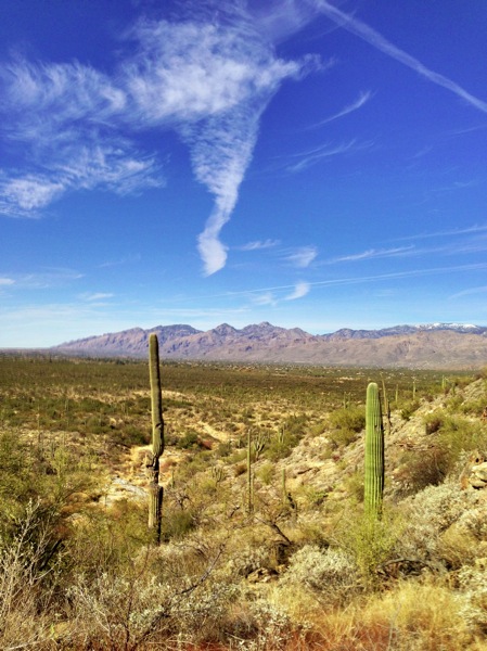
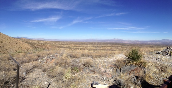
A view from a highpoint along the Kartchner Caverns Foothills Loop Day 3: Kartchner Caverns State Park - Kartchner Foothills Loop This would be a new place for me. Mom and Dad came here a decade earlier but wanted to return. The caverns were first explored over 30 years ago and now what really strikes one beyond the cool rock formations you find slowly growing in the caern is the engineering that has gone into opening up a small section of the cavern to the public. It's an ongoing process to keep the environment of the cavern to something pretty much approaching what it should be if people weren't invading. This means keeping track and then carefully cleaning anything that gets touched by people, ensuring no lint or other detritus is left behind, carefully controlling the humidity, and so much more. We did the Rotunda Tour which is about 90 minutes long. You slowly move through the wheelchair accessible cave along wide but dimly lit ramps. My dark-adapted vision may well be getting less good but unless you are normally fearful in caverns you won't have any trouble. The tour does give you a fine hence to see stalagmites, stalactites, rock draperies, massive columns, and more. The little light and music show in front of Kublakahn (sp) which is a staggeringly large column is enjoyable. I strongly encourage you to walk the Foothills Trail after visiting the cavern. This is easy trail that loops through the foothills and gives you a slightly different view of desert flora than you may have already seen . This is because their is a bit more water around than normal which creates a slightly different environment. Granted the water isn't visible in pools or streams but things do look different. If you decide to take the side trail, perhaps a half mile long with about an elevation gain of 200 feet, to the top of one of the hills you will be treated to some great panoramic views.
Cottonwoods in Pima Canyon Day 4: Pima Canyon This is a popular hike for Tucsonans. Unlike many hikes this one starts well within the city limits. You actually begin the hike by walking a right-of-way path through private land behind several nicely tucked into the scenery homes. There is a bit of ascending to do at first but for most people it will be easy going. I personally don't much care for walking across the slick rock sections but that owes more to my vision than anything else. Within half a mile you leave the private land for the wilderness area and not long after you enter the canyon proper (heading northeast). As you move into the canyon, following a rock-strewn trail, the sounds of Tucson fade away to pretty much nothing. In the morning the canyon is shady and it's clear that sometimes water is readily available as sections with a few trees including cottonwoods and many taller shrubs abound. I'm fairly sure there is never an actual stream flowing as you can find in Sabino Canyon (the 7 Falls hike say). While walking in the canyon is different than the more open desert walking and that is a nice change I think we all prefer to bigger views and sense of openness that you find along the other trails we have hiked. I also personally prefer Sabino Canyon even though it can be more crowded (Pima Canyon gets busy; we saw many more people on our way back out in early afternoon). The rocky trailbed is bothersome for me though most people won't be overly affected by the rocks. We hiked in just over 3 miles to where a dam is supposed to be (just over 6 miles round-trip; Dad actually did a bit over 8 miles as he realized he left the guidebook with over ten years of notes at the car and wanted to be sure no one swiped it off the car's roof so he hustled back to the car and returned meeting us just after we left our furthest point into the canyon). We found the many slick rocks which make for a fine lunch spot and I know people went well beyond this area but we did not find the dam. Our understanding is that it is in that area but easily missed. I suppose since a dam is there water must have been present in large enough amounts to make it worth building (rather like Garwood's dam). But none is visible now.
Day 5: Douglas Spring Trail to Ernie's Falls We like the whole area around Douglas Springs Trail and Bridal Wreath Falls. While the Douglas Springs trail can be quite busy it is still a nice area to explore. This year instead of visiting Bridal Wreath Falls (I wish we had as it would have only added 20-30 minutes) we decided to check out Ernie's Falls which we knew nothing about. From what I could gather the trail to Ernie's Falls would lead us to a creek which would in turn take us to the waterfall. We had no idea what we would find. Setting out on a mostly sunny morning we began the gradual ascent towards the trail junction of Bridal Wreath and Ernie's Falls 2.7 miles from the trailhead. The trail starts out level for the first two thirds of a mile before quickly ascending for a time before leveling out and then ascending again before again leveling out. The ascents aren't all that steep and the trail follows good switchbacks all the way. In time we passed by a slickrock area we often have had snacks at that is less than a half mile from the trail junction. By this point we had seen a few people, including many trail runners, but it didn't really feel overwhelmingly busy to us. Once we turned off on the trail to Ernie's Falls it became quite clear that people do not go this way. It is a good easy to follow trail that descends gradually for about 0.6 miles to the creek and National Park boundary. As we walked along the trail it seemed to me the flora changed a bit. All of a sudden it seemed as though there were more grasses around us along with a few shrubs here and there. When we reached the creek-bed we found it utterly dry and that was definitely a good place to stop. I do wonder when water flows through this creek and what the waterfall might be like. Returning to the trailhead and our car makes this an easy out-and-back hike of about 6.6 miles. I'm glad we went somewhere new even though we did not see any water flowing. Maybe we will return to Ernie's Falls one day.
Me along the Hugh Norris Trail
The Hugh Norris Trail at EveryTrail
(Not sure all the photos appear on the map or in the proper places)
EveryTrail - Find the best Hiking near Tucson, Arizona
Day 6: The Hugh Norris Trail The Hugh Noris Trail eventually takes you to Wassen Peak which we have visited numerous times in the past. In the past we have found our way to that peak from the Kings Canyon Trail if memory serves. It has been years since we hiked the Hugh Norris Trail. In fact our notes suggest that the trail may have changed some in the intervening years; at least we think some of the things we noticed this time would certainly have made it into our notes. We decided as time went by that we would not hike all the way to Wassen Peak. We would go as far as we would based on how we felt for the last day. The trail winds steadily upwards through a series of switchbacks that are made up of a stunningly large number of steps. This is one of those features of the trail that we feel we would have written into our notes. The steps do seem to make the climbing tougher as you have to raise your foot up high to ascend each stair. As you climb you are treated to expansive views of the desert and in the foreground massive boulders that add character to the scenery. It is a trek with some of the more distinctive vistas around. When not ascending you get to walk good paths along ridges that sport some desert flora. But these are just interludes to the general ascent. The trail is moderately popular. We saw many, though by no means the most, people heading in both directions throughout the hiking day. It is not so crowded that you feel a sense of loss as people ruin the quietude of the desert. We enjoyed the hike even though it does get a bit tiring always seeming to be climbing up. But taking breaks now and then for a snack, by a particularly photogenic egg-shaped boulder, or to have lunch make the hike fun. The overall quality of the trail is superb but you should be used to steady hill climbing up and down if you want to tackle this trail. We decided in the end not to go go quite all the way to the trail junction with the Kings Canyon Trail that lies just 0.3 miles from Wassen Peak itself. It just seemed a tad silly at the end and we knew it would be breezy at that junction and the views would only be a bit different (and nothing we haven't seen before) from where we were standing as we watched two mountain bikers (a no-no I am pretty sure) rapidly descend towards us. All in all I think the out-and-back hike covered 8 miles and that includes somewhere around 2,300 feet of ascent and 2,300 feet of descent. This was a good hike to end our trip with even though I do kind of wish we had gone to the trail junction as originally planned. There are several more photos that I strongly encourage you to view by following this link. Remember you should really click the photos to see them at the best resolution and to view the associated commentary. As you can see from the sampling of pictures we generally had utter clear weather but some mornings started out a bit overcast which helped keep the temperature down and added a bit of zest to the sky.

Saturday, January 17, 2009

Wandering Knight Episode 13 Photos


Episode 13 of Wandering Knight Podcast ((direct link, We’re Not 25th) is now online.


The photos you see here were hurridly snapped by Paul Haan.


The scene at the start/end point before the rally begins. I would later learn that 22, of a possible 25, teams would enter the rally. A pretty good turn out considering it is winter and many people probably would rather stay inside. 13:49.


On the road again. Heading for our second geocache. 14:39.


We found the second cache. We could hardly believe it especially since we found it very quickly. Sure pausing for a minute to snap a couple photos cost us precious time but hey sometimes you gotta just go for it. 14:46.


Triumphal Return. We would finish 15th. We actually were checked back in a bit before this photo was shot. 15:00.

Saturday, March 1, 2008

The Power of Snow


I started to write this last night and did not finish. Now things have, naturally, changed and I am re-writing this entry. If I wait another day (I won't) who know what could happen.


Winter is hanging on. Thursday night it began to snow a bit. I had enough snow on the sidewalk that it made sense to me to push it off before going to bed. When the snow is fluffy it's an easy job and only took a couple minutes with the big broom to finish. The area was getting a fresh white washing and that was a welcome sight. The next day (Friday) the snow continued to fall leaving us with a few inches of fresh high quality packing snow. Kids everywhere probably were making super snowmen or having good snowball fights. For me it was another chance to clear the sidewalk and driveway which again did not take that long. More important to me though is the fact that the snow changes things. Even on an overcast day like today was the snow makes things better. It brightens the world, covers the slush mounds, and adds a muffed quality to what traffic you hear that makes those sounds of the town less noticeable and henceless annoying.
Snow also does something else, at least at night. Snow makes the world feel more comfortable. Even if it is cold and windy the world is more comfortable. But this night when the wind was almost still and the temperature was not that much below freezing and I was comfortably warm in my wool coat walking home from The Ark just before midnight the world felt more pleasant yet. Sure I had just left a fantastic concert by Bill Kirchen but his shows will always bring a smile to a person's face. The snowbound world of subdued yet encompassing light, soft crunches as cars now and then slowly went by, and the crunch and slide of my own steps through the snow on the sidewalks combine to make the 10 minute walk home a real pleassure. Most times it's just a walk.
Today (Saturday) the sun burst forth and the snow began to melt.Sidewalks that had been well taken care of the day before are now devoid of snow as the sun bakes the cement. Plows have rumbled through all the side streets mounding up piles of dirty snow leaving dirty colored slush filled streets behind. Pools of slush and water are forming at every street intersection challenging you to not get your socks soaked as you try to avoid them. But the snow is still fresh and no doubt kids are having a blast. Could I get somewhere to do a long walk in the woods I would. This is the kind of winter day that makes winter especially glorious. We've had a good number of these this year and are actually above average which is a wonderful change from the last couple of winter seasons.