Saturday, May 31, 2014

West Highland Way Day 1 - Milngavie to Drymen

Moonrise Over Drymen.jpg.pngIf you stay at the Buchanan Arms hotel (a Best Western) in Drymen there is a lookout point across the road about a tenth of a mile distant. For away to the west you can just see Loch Lomond but looking east, like here, you are treated to a lovely near full moonrise over Drymen.
It's been a rather long day and I don't think that is going to change. We have completed our first day of hiking and it was a good day ending on a real high note. In pretty much all ways that matter things worked out wonderfully. I hope that doesn't mean down the line some form of karmic joke is played on us by rendering a truly lousy day. But I won't dwell on that because it's pointless.
Dad at the Start.jpg
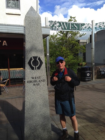
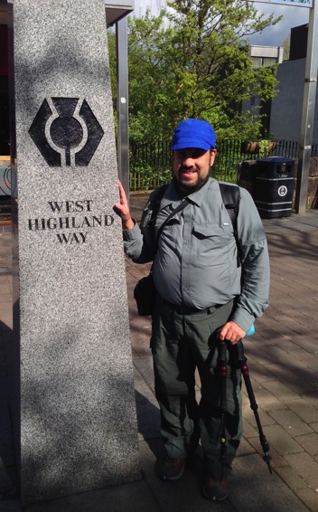
Its time to start our 8-day trek along the West Highland Way. This pylon marks the start in the town of Milngavie ("Mel-guy" is how I think it's said) and winds generally northward 96 odd miles to Fort William.
Ken at the Start.jpgIt's actually warm enough to be hiking in shorts like Dad. I did change later and though I didn't shed the shirt I certainly rolled the sleeves up.
DSCN0968.jpg
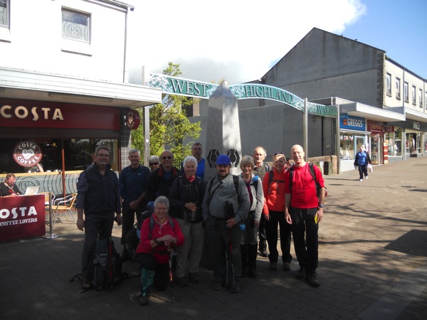
Here is our group of 11 hikers and the leader getting ready to sally forth on the West Highland Way.

We started our trek in Milngavie (Mel-guy) around 10:00 under mostly sunny skies and surprisingly warm temperature. We thought we could expect some showers to creep in a bit after noon but we were prepared for that. It was already a bit warmer than expected so we , or at least I, were hoping things would turn out better than forecast. We left the village strolling through park land by the Allender Water (River?). The going was easy at this point and marred only by the fact that this close to the town and the official southern terminus this is a popular stretch of trail. I can't begin to tell you how many people and dogs, large and small, we saw. The dogs, by the way, were petty much all off leash. if you are nervous around dogs perhaps you should keep that in mind if you decide to hike here.

IMG_5829.JPG
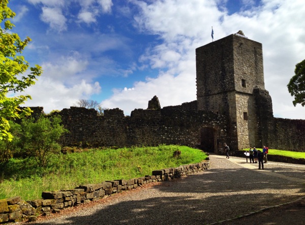
While we aren't on the official West Highland Way right now I think this diversion is well worth it as we get to see this old castle. Mugdock Castle was built in 1372 and the 59 foot southwest tower remains.
We would have to take an alternate route, mostly on the John Muir Way I believe, but this was hardly a bad thing. It let us discover Mugdock Castle which was quite a find and well worth several minutes of exploration. From there we would continue on our way through rolling valleys and through sheep grazing lands. Usually we followed country two-tracks and now and then a stretch of macadam road. The bit of what you would call "trail" had really only been underfoot early on. But the scenery was wonderful and the weather was still treating us gently with generally deep blue skies dotted with puffy cumulus clouds and a modest breeze that kept us cool.
IMG_5851.JPG
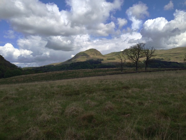
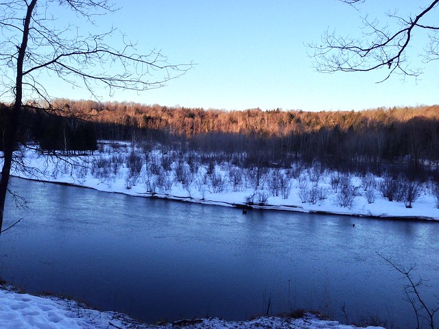
We've returned to the official West Highland Way and will soon be walking along an old narrow gauge (I think) railway bed. As I understand it a huge number of railways were dismantled back in the 60s (70s?) in an attempt to save money. Done under the auspices of a minister named Beaching. I suspect that it may have been necessary but it certainly wasn't welcomed. But right now we are near the Dumgoyach Standing Stones. They're a few hundred feet off the trail (east) in a field. I wish we'd taken the time to slog through the scrub and heather to get a better look. This is interesting pastureland to walk through surrounded by tall rocky hills (Fells).
Passing by the standing stone at Dumgoyach was interesting even though we couldn't get all that close to this set of 4 stones that date back to somewhere around 3650BC. What always strikes me about astronomical observatories like these is the amount of perseverance , keen observation, and careful thought must go into the creation process. To be sure standing stone that can help you know when the equinoxes are as well as summer solstice must be quite useful in so many respects but the actual raising of the stone, no mean feat, is the least of the challenges amongst many seriously big tasks. I wish we had had time to plod through the field, though maybe a bit tough going, to get a better look. 
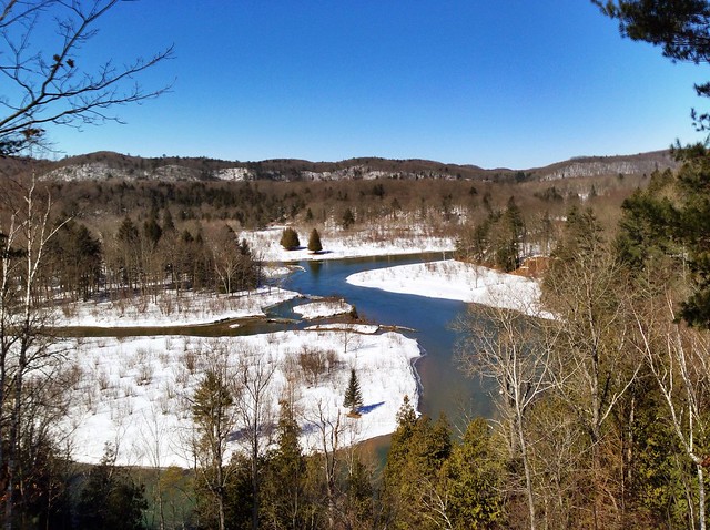
The afternoon wore on and the weather remained superb as we walked several miles of old railroad grade. It may not be terribly exciting trail but again the expansive views weren't bad and we enjoyed ourselves as we strolled. The last couple miles again on paved roads were a bit of a drag but that is due, at least in part, to the fact that we were walking on paved roads. To be sure they were not that heavily trafficked but they're still paved roads and that means a bit tiring on the feet. At about 16:30 we returned to the Buchanan Arms here in the very small village of Drymen and after a suitably fattening dinner most of us wandered the 0.1 miles to a viewpoint that looks out over Loch Lomond in the far western distance. It was a wonderful day with a quite clear sky that had only managed to produce a couple quite measly sun-showers a few hours earlier - barely enough to even notice. Watching the nearly full moon slowly rise as the sun set was a fine way to end this first 13 mile (1,000 feet of ascent/descent more or less) day of hiking. Tomorrow we deal with a 15 mile day of hiking that'll feature about 1,500 feet of ascent and descent if you accept the data from one source (more like 2,200 and 2,600 according to the official website). I know I am a bit tired now but I think I will be more than up to the challenge tomorrow brings. I am looking forward to it.

To see all 10 photos, at a much greater size, for this day visit the Flickr photo album here.

Thursday, May 22, 2014

West Highland Way Days 6-8


West Highland Way Days 6-8


Sunday, May 18, 2014

West Highland Way Days 3-5


Thursday, May 15, 2014

West Highland Way Days 1-2


Wednesday, May 7, 2014

Rhode Island beach walk


May 7, 2014 9:24 am - a very nice beach. Many of the houses suffered damage from hurticane Sandy and work continues to repair them.

Name: Track 094
Date: May 7, 2014 9:24 am
Map:
(valid until Nov 3, 2014) View on map
Distance: 2.20 miles
Elapsed Time: 53:10.6
Avg Speed: 2.5 mph
Max Speed: 3.9 mph
Avg Pace: 24' 13" per mile
Min Altitude: 2 ft
Max Altitude: 81 ft
Start Time: 2014-05-07T13:24:03Z
Start Location:
Latitude: 41.341525º N
Longitude: 71.694768º W
End Location:
Latitude: 41.341716º N
Longitude: 71.694725º W


Sunday, May 4, 2014

#35: Manistee River Trail March Winter Weekend 2014


Manistee River Sunset

It has been a while since I've managed to go on any winter backpacking trips. In fact, it has been several years since I've actually done more than day hiking in the winter even if some of those trips were based out of rustic cabins in places like Wilderness State Park by Mackinaw City or the cabins in the Waterloo-Pinckney Recreation Area. So this two-night weekend spent hiking a portion of the Manistee River Trail with friends was a real treat. Joined by experienced, in some cases (maybe all), winter backpackers Doug, Ewa, and Paul (and Paul's dog Capone) we planned a fairly modest couple days of hiking in and then back out on the Manistee River Trail. Their was a time when I had hiked the entire loop which includes the North Country Trail on the other side of the Manistee River covering about 21 miles over a weekend in snowshoes but this trip would be nowhere nearly that ambitious. Our plan was to drive to Red Bridge Friday night and either camp right there or somewhere nearby, hike however far on Saturday to some point along the trail, and return Sunday for the drive back to our respective homes.

We would meet at Barski Bar in Baldwin and after dinner drive to Red Bridge to start our hiking weekend. I suspect that their aren't that many places to eat in Baldwin, Michigan. Barski's though has some truly wonderful food. I imagine the burger I had that was topped with an egg plus the more usual burger toppings would make a cardiologist cringee but boy was it tasty. The meals everyone else had create similar amounts of gastronomic pleasure and none of us worried much about the calories. After all, we were about to go on a winter hike. It would be well past sunset when we managed to park our two cars in the unplowed snowy parking lot at Red Bridge. We hoisted our packs, heavy with winter gear, grabbed our snowshoes and began the hike which starts with a quarter-mile tromp down North Coates Highway to where the MRT trailhead is. Once there we did a bit more gear re-arranging , stepped into our snowshoes, and began the slow process of hiking along the narrow snowy Manistee River Trail.


********** ********** **********


Saturday Sunrise Camp

We were in no rush to leave camp Saturday morning. While we all started to stir not long after sunrise we did not actually leave camp until about 11:00.  We were only going to hike about 3 miles so leaving so late was hardly a hardship. When we left to hike the rolling hills it was overcast but nice enough. We made our way methodically along the trail enjoying the frequent views of the river as we crunched loudly through the snow. When we reached our planned, well the site Paul figured would be good mostly because it has such fine river views, around 14:00 (perhaps a bit earlier than that) we settled in for a fine lazy afternoon. The sun was out and that made setting up camp a much nicer though perhaps not really all that much quicker of a task. Of course, it was far too early to be done with our day so after dawdling about camp for a while we decided to hike to Slagle Creek. What a wonderful hike that turned out to be. Sure hiking down in and then out of a ravine along a slick hillside was a tiny bit of a chore but only a small annoyance. The sun had conquered the clouds that had been out earlier and it was a fine day to be out enjoying the trail. Settling down later to soak up some of that sun along the southwest facing ridge by our camp was also a real treat. 


********** ********** **********


Manistee River Islands 2

The hike back to the cars was as enjoyable as the hike out. To be sure the day was actually somewhat colder but that hardly matters when you're tromping through snow that if you break through will rise well past your calf. We did break camp a bit more quickly but we still weren't in anything like a real hurry. We had ample time to hike out and some of us were lucky enough to spy various wildlife along the way including a couple bald eagles.  We paused a few times for enjoyable breaks, usually in places at least a little out of the wind though still with views of the river down below. I think the biggest surprise though of our return hike came near its end. On the way out, seemingly farther along than it really was we had to squeeze by a juniper bush that was pushing well into the trail. On our left the trail vanished into a drop-off that seemed to drop easily 30 feet into blackness that likely concealed a lot of muck. Getting past that bush was something of a trial. When we came to it in the glare of a high sun it was far easier to edge past it and the drop off turned out to be at most 8 feet and nowhere near as imposing let alone dangerous. Hiking at night changes your perspective.

We reached our cars a little after 14:00. Naturally we had to have a post-hike meal and so a return visit to Barski Bar was called for. I must say the rueben I had was even tastier than the burger of Friday night. Everyone else agreed their meals were equally good. After that fine meal it was time for Ewa and I to head back towards Ann Arbor while Paul and Doug returned to Grand Rapids. It had been a very good weekend indeed.

Check out this episode!

MRT Winter Trip
Google album (19 photos): Google album

Flickr album (15 photos): Flickr album